| Surname |
location |
Type |
entry |
image
|
|
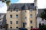
Lecropt Church
|
near Bridge of Allan
56 ° 9 ′ 30.7 " N , 3 ° 57 ′ 54" W.56.158527777778 -3.965
|
church
|
173
|

|
|
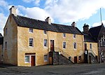
Keir House Manor
|
near Dunblane
56 ° 10 '14.1 " N , 3 ° 58' 42.8" W.56.170583333333 -3.9785555555556
|
farm
|
3918
|
|
|
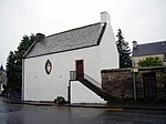
South Lodge by Keir House
|
near Dunblane
56 ° 10 ′ 7.4 " N , 3 ° 58 ′ 23.5" W.56.168722222222 -3.9731944444444
|
Residential buildings
|
3921
|
|
|
Keir House
|
near Dunblane
56 ° 9 ′ 57.7 " N , 3 ° 58 ′ 57.9" W.56.166027777778 -3.98275
|
Mansion
|
3935
|
|
|
Old Auchentroig
|
near Buchlyvie
56 ° 6 ′ 43.9 " N , 4 ° 20 ′ 32.3" W.56.112194444444 -4.3423055555556
|
Residential buildings
|
3937
|
|
|
Queen Victoria School
|
Dunblane
56 ° 12 ′ 3.1 " N , 3 ° 57 ′ 11" W.56.200861111111 -3.9530555555556
|
school
|
3986
|
|
|
Chapel of the Queen Victoria School
|
Dunblane
56 ° 12 '0 " N , 3 ° 57' 9.6" W.56.2 -3.9526666666667
|
church
|
3987
|
|
|
Sundial from Cromlix House
|
near Kinbuck 56 ° 13 '52 .2
" N , 3 ° 57' 58.9" W.56.231166666667 -3.9663611111111
|
sundial
|
3997
|
|
|
Loch Venachar dam
|
near Callander
56 ° 13 ′ 47.4 " N , 4 ° 15 ′ 47.4" W.56.229833333333 -4.2631666666667
|
Hydraulic structure
|
4060
|
|
|
Couligartan Aqueduct 1
|
near Loch Ard
56 ° 10 ′ 18.5 " N , 4 ° 29 ′ 57.7" W.56.171805555556 -4.4993611111111
|
bridge
|
4151
|
|
|
Couligartan Aqueduct 2
|
near Loch Ard
56 ° 10 ′ 10.5 " N , 4 ° 29 ′ 46.2" W.56.169583333333 -4.4961666666667
|
bridge
|
4152
|

|
|
Couligartan Aqueduct 3
|
near Loch Ard
56 ° 9 ′ 56.7 " N , 4 ° 29 ′ 15.5" W.56.16575 -4.4876388888889
|
bridge
|
4153
|
|
|
Duchray Bridge
|
near Loch Ard
56 ° 9 ′ 42.4 " N , 4 ° 28 ′ 34.2" W.56.161777777778 -4.4761666666667
|
bridge
|
4155
|
|
|
Edinample Castle
|
near Lochearnhead
56 ° 22 ′ 31.7 " N , 4 ° 15 ′ 56.7" W.56.375472222222 -4.26575
|
Castle
|
4198
|
|
|
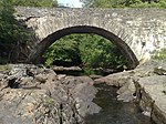
Drip Old Bridge
|
near Stirling
56 ° 8 ′ 14.4 " N , 3 ° 58 ′ 50.2" W.56.137333333333 -3.9806111111111
|
bridge
|
6725
|

|
|
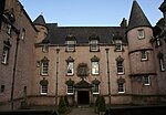
Catter House
|
near Drymen
56 ° 3 '7.8 " N , 4 ° 27" 23.1 " W.56.052166666667 -4.4564166666667
|
Mansion
|
7628
|
|
|
Gribloch House
|
near tilt
56 ° 6 '52.9 " N , 4 ° 11' 17.3" W.56.114694444444 -4.1881388888889
|
villa
|
8191
|
|
|
Doune stable
|
near Doune
56 ° 12 '12.1 " N , 4 ° 5' 7.6" W.56.203361111111 -4.0854444444444
|
Stables
|
8220
|
|
|
Old Newton House
|
Doune
56 ° 11 ′ 11.6 " N , 4 ° 2 ′ 43.8" W.56.186555555556 -4.0455
|
Tower House
|
8227
|
|
|
Deanston Mill
|
Deanston
56 ° 11 '22.7 " N , 4 ° 4' 16.1" W.56.189638888889 -4.0711388888889
|
Industrial building
|
8230
|
|
|
Deanston Mill's weaving mill
|
Deanston
56 ° 11 '21.4 " N , 4 ° 4' 18.3" W.56.189277777778 -4.07175
|
Industrial building
|
8231
|
|
|
Lanrick Macgregor Monument
|
near Deanston
56 ° 12 '2.4 " N , 4 ° 7' 22.2" W.56.200666666667 -4.1228333333333
|
monument
|
8244
|
|
|
Moirlanich Longhouse
|
near Killin
56 ° 28 ′ 38.5 " N , 4 ° 20 ′ 9.7" W.56.477361111111 -4.3360277777778
|
Residential buildings
|
8263
|
|
|
Bridge of Dochart
|
Killin
56 ° 27 '46.1 " N , 4 ° 19' 11.9" W.56.462805555556 -4.3199722222222
|
bridge
|
8275
|
|
|
Dochart Viaduct
|
Killin
56 ° 27 ′ 54.9 " N , 4 ° 18 ′ 56" W.56.46525 -4.3155555555556
|
bridge
|
8281
|

|
|
Kincardine-in-Mentieth Parish Church
|
Blair Drummond
56 ° 9 '54.1 " N , 4 ° 3' 50.5" W.56.165027777778 -4.0640277777778
|
church
|
8431
|

|
|
Buchanan Monument
|
Killearn
56 ° 2 ′ 37.7 " N , 4 ° 22 ′ 23" W.56.043805555556 -4.3730555555556
|
monument
|
10389
|

|
|
Auchenibert
|
Killearn
56 ° 2 ′ 32.3 " N , 4 ° 21 ′ 35.6" W.56.042305555556 -4.3598888888889
|
villa
|
10422
|
|
|
Gargunnock House
|
Gargunnock
56 ° 7 '33.3 " N , 4 ° 4' 4.4" W.56.125916666667 -4.0678888888889
|
Mansion
|
10438
|

|
|
Old Leckie House
|
near Gargunnock
56 ° 7 '36.9 " N , 4 ° 6' 33.9" W.56.126916666667 -4.1094166666667
|
Mansion
|
10445
|
|
|
Blairlogie Castle
|
Blairlogie
56 ° 9 '3.5 " N , 3 ° 53' 20.2" W.56.150972222222 -3.8889444444444
|
Tower House
|
10461
|
|
|
Culcreuch Castle
|
near Fintry
56 ° 3 '43.2 " N , 4 ° 13' 3.3" W.56.062 -4.2175833333333
|
Tower House
|
10467
|

|
|
Dun Eaglais
|
Tilt
56 ° 7 ′ 39.5 ″ N , 4 ° 10 ′ 2.4 ″ W.56.127638888889 -4.1673333333333
|
villa
|
12515
|
|
|
Milnholm Hatchery
|
near Stirling
56 ° 3 '59.2 " N , 3 ° 57' 16.2" W.56.066444444444 -3.9545
|
Fish farm
|
15275
|
|
|
Bannockburn House
|
near Stirling
56 ° 4 ′ 40.3 " N , 3 ° 54 ′ 55.1" W.56.077861111111 -3.9153055555556
|
Mansion
|
15277
|
|
|
Touch house
|
near Stirling
56 ° 6 ′ 40.2 " N , 4 ° 0 ′ 22.5" W.56.111166666667 -4.00625
|
Mansion
|
15295
|
|
|
Auchenbowie House
|
near Stirling
56 ° 3 ′ 51.5 " N , 3 ° 55 ′ 51.8" W.56.064305555556 -3.9310555555556
|
villa
|
15303
|
|
|
Howietoun Fishery
|
near Stirling
56 ° 4 ′ 21.9 " N , 3 ° 57 ′ 11.3" W.56.07275 -3.9531388888889
|
Fish farm
|
15306
|
|
|
Hayford Mills
|
Cambusbarron
56 ° 6 ′ 46.4 " N , 3 ° 58 ′ 13.6" W.56.112888888889 -3.9704444444444
|
Industrial building
|
19117
|
|
|
Cardross House
|
near tilt
56 ° 9 '4.4 " N , 4 ° 14' 50.7" W.56.151222222222 -4.2474166666667
|
Mansion
|
19708
|

|
|
Bridge of Ardoch
|
Doune
56 ° 11 '14.2 " N , 4 ° 2' 52.5" W.56.187277777778 -4.0479166666667
|
bridge
|
24667
|

|
|
Bridge of Teith
|
Doune
56 ° 11 ′ 11.8 ″ N , 4 ° 3 ′ 40.6 ″ W.56.186611111111 -4.0612777777778
|
bridge
|
24668
|
|
|
Doune market cross
|
Doune
56 ° 11 ′ 22.8 ″ N , 4 ° 3 ′ 10 ″ W.56.189666666667 -4.0527777777778
|
Market cross
|
24671
|

|
|
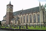
Dunblane Cathedral
|
Dunblane
56 ° 11 '22.1 " N , 3 ° 57' 54.3" W.56.189472222222 -3.9650833333333
|
church
|
26361
|
|
|
Ault Wharrie
|
Dunblane
56 ° 11 '7.4 " N , 3 ° 56" 52.3 " W.56.185388888889 -3.9478611111111
|
villa
|
26365
|
|
|
Leighton Library
|
Dunblane
56 ° 11 '19.1 " N , 3 ° 57' 51.9" W.56.188638888889 -3.9644166666667
|
Library
|
26371
|
|
|
Dunblane Museum
|
Dunblane
56 ° 11 '20.4 " N , 3 ° 57' 51.4" W.56.189 -3.9642777777778
|
museum
|
26372
|
|
|
Church of the Holy Rude
|
Stirling
56 ° 7 ′ 14.9 ″ N , 3 ° 56 ′ 40 ″ W.56.120805555556 -3.9444444444444
|
church
|
41083
|

|
|
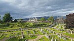
Church of the Holy Rude cemetery
|
Stirling
56 ° 7 '17 " N , 3 ° 56" 43.9 " W.56.121388888889 -3.9455277777778
|
graveyard
|
41084
|

|
|
Holy Trinity Episcopal Church
|
Stirling
56 ° 7 ′ 5.9 ″ N , 3 ° 56 ′ 34.1 ″ W.56.118305555556 -3.9428055555556
|
church
|
41089
|

|
|
St Ninians Old Parish Kirk
|
Stirling
56 ° 6 ′ 9.6 ″ N , 3 ° 56 ′ 15.8 ″ W.56.102666666667 -3.9377222222222
|
church
|
41095
|
|
|
St Ninians Old Parish Kirk cemetery
|
Stirling
56 ° 6 ′ 9.7 " N , 3 ° 56 ′ 14.6" W.56.102694444444 -3.9373888888889
|
graveyard
|
41096
|

|
|
Athenaeum
|
Stirling
56 ° 7 ′ 6.5 ″ N , 3 ° 56 ′ 18.7 ″ W.56.118472222222 -3.9385277777778
|
Clubhouse
|
41100
|

|
|
Cowane's Hospital
|
Stirling
56 ° 7 '13.8 " N , 3 ° 56" 42.2 " W.56.1205 -3.9450555555556
|
hospital
|
41101
|

|
|
Old Stirling City Jail
|
Stirling
56 ° 7 ′ 11.8 " N , 3 ° 56 ′ 38.5" W.56.119944444444 -3.9440277777778
|
jail
|
41104
|

|
|
Stirling Tolbooth
|
Stirling
56 ° 7 '14.5 " N , 3 ° 56" 34.1 " W.56.120694444444 -3.9428055555556
|
town hall
|
41110
|

|
|
Wallace Monument
|
Stirling
56 ° 8 '19.7 " N , 3 ° 55' 3.9" W.56.138805555556 -3.91775
|
tower
|
41118
|

|
|
Old Stirling City Cemetery
|
Stirling
56 ° 7 '17.9 " N , 3 ° 56" 43.7 " W.56.121638888889 -3.9454722222222
|
graveyard
|
41126
|
|
|
Old Bridge
|
Stirling
56 ° 7 '43 " N , 3 ° 56" 12.9 " W.56.128611111111 -3.9369166666667
|
bridge
|
41129
|

|
|
Stirling train station
|
Stirling
56 ° 7 '11.8 " N , 3 ° 56' 6.5" W.56.119944444444 -3.9351388888889
|
railway station
|
41131
|

|
|
Stirling Highland Hotel
|
Stirling
56 ° 7 '9.7 " N , 3 ° 56' 30.8" W.56.119361111111 -3.9418888888889
|
hotel
|
41133
|

|
|
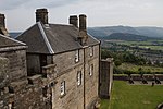
Outer defensive wall of Stirling Castle
|
Stirling
56 ° 7 '24 " N , 3 ° 56" 48.5 " W.56.123333333333 -3.9468055555556
|
Castle complex
|
41136
|

|
|
Vorwerk of Stirling Castle
|
Stirling
56 ° 7 '25 " N , 3 ° 56' 50.2" W.56.123611111111 -3.9472777777778
|
Castle complex
|
41137
|

|
|
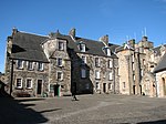
Palace of Stirling Castle
|
Stirling
56 ° 7 '24.8 " N , 3 ° 56" 52.4 " W.56.123555555556 -3.9478888888889
|
palace
|
41138
|

|
|
Great Hall of Stirling Castle
|
Stirling
56 ° 7 '26.5 " N , 3 ° 56" 51.8 " W.56.124027777778 -3.9477222222222
|
Castle complex
|
41139
|

|
|
Royal Chapel of Stirling Castle
|
Stirling
56 ° 7 ′ 27.2 " N , 3 ° 56 ′ 53.7" W.56.124222222222 -3.94825
|
church
|
41140
|

|
|
The Mint
|
Stirling
56 ° 7 ′ 27.1 ″ N , 3 ° 56 ′ 51 ″ W.56.124194444444 -3.9475
|
Castle complex
|
41141
|

|
|
Kitchen and large battery of Stirling Castle
|
Stirling
56 ° 7 '25.6 " N , 3 ° 56' 49" W.56.123777777778 -3.9469444444444
|
Castle complex
|
41142
|
|
|
Old Royal Palace of Stirling Castle
|
Stirling
56 ° 7 '26.5 " N , 3 ° 56" 55.2 " W.56.124027777778 -3.9486666666667
|
palace
|
41143
|
|
|
Stirling Castle sundial
|
Stirling
56 ° 7 '27.8 " N , 3 ° 56" 55.4 " W.56.124388888889 -3.9487222222222
|
sundial
|
41144
|
|
|
Regimental quarters at Stirling Castle
|
Stirling
56 ° 7 '25.4 " N , 3 ° 56' 49.8" W.56.123722222222 -3.9471666666667
|
Castle complex
|
41145
|
|
|
Darnley's House
|
Stirling
56 ° 7 '14.1 " N , 3 ° 56' 29.9" W.56.120583333333 -3.9416388888889
|
Residential buildings
|
41239
|

|
|
Moir of Leckie's House
|
Stirling
56 ° 7 '14.1 " N , 3 ° 56' 28.2" W.56.120583333333 -3.9411666666667
|
Residential buildings
|
41240
|
|
|
James Norrie's Lodging
|
Stirling
56 ° 7 '15.4 " N , 3 ° 56' 33.3" W.56.120944444444 -3.9425833333333
|
Residential buildings
|
41246
|

|
|
Argyll's Lodging
|
Stirling
56 ° 7 ′ 18.5 ″ N , 3 ° 56 ′ 37.3 ″ W.56.121805555556 -3.9436944444444
|
Residential buildings
|
41255
|
|
|
Bruce of Auchenbowie's House
|
Stirling
56 ° 7 ′ 13.9 ″ N , 3 ° 56 ′ 37.5 ″ W.56.120527777778 -3.94375
|
Residential buildings
|
41464
|
|
|
John Cowane's House
|
Stirling
56 ° 7 ′ 19.5 ″ N , 3 ° 56 ′ 33.1 ″ W.56.122083333333 -3.9425277777778
|
Residential buildings
|
41466
|

|
|
Glengarry Lodge
|
Stirling
56 ° 7 ′ 11.5 ″ N , 3 ° 56 ′ 30 ″ W.56.119861111111 -3.9416666666667
|
Residential buildings
|
41484
|
|
|
Weir of Deanston Mill
|
near Deanston
56 ° 11 '56.2 " N , 4 ° 5' 33.2" W.56.198944444444 -4.0925555555556
|
Hydraulic structure
|
47650
|
|
|
Bannockburn Rotunda
|
Stirling
56 ° 5 '36.1 " N , 3 ° 56' 16.1" W.56.093361111111 -3.9378055555556
|
monument
|
49860
|

|
|
Weir of the Royal Cottage Aqueduct
|
Loch Katrine
56 ° 14 ′ 52.1 ″ N , 4 ° 32 ′ 57.3 ″ W.56.247805555556 -4.54925
|
Hydraulic structure
|
50298
|
|
|
Sundial in the Cayzer family's private cemetery
|
Gartmore
56 ° 8 ′ 38.9 " N , 4 ° 22 ′ 55.9" W.56.144138888889 -4.3821944444444
|
sundial
|
50406
|
|
|
Loch Arklet Dam
|
Loch Arklet
56 ° 14 ′ 53.4 " N , 4 ° 39 ′ 17.2" W.56.248166666667 -4.6547777777778
|
Hydraulic structure
|
50461
|

|
|
Castle Burn Aqueduct
|
near Loch Ard
56 ° 9 ′ 27.6 " N , 4 ° 27 ′ 51.6" W.56.157666666667 -4.4643333333333
|
bridge
|
51152
|

|
|
Rector's Villa of the University of Stirling
|
Stirling
56 ° 8 ′ 56.6 " N , 3 ° 54 ′ 53" W.56.149055555556 -3.9147222222222
|
villa
|
51322
|
|
|
Pathfoot Building
|
Stirling
56.149277777778 -3.9267222222222
|
university
|
51327
|
|


.jpg)


.jpg)


.jpg)


.jpg)


