| Surname
|
region
|
Waters
|
position
|
Year of construction (s)
|
Tower height
|
Fire height
|
Identifier
|
image
|
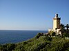
| Phare Cap des Trois Fourches
|
Morocco Oriental Oriental
|
Alboran Sea
|
35 ° 26 '17.2 " N , 2 ° 57' 46.9" W.35.43812 -2.96302
|
1909
|
18 m
|
109 m
|
Fl (3 + 1) W.20s
|

|
| Phare Ilot d'Arzew
|
Algeria Oran Oran
|
Mediterranean Sea
|
35 ° 52 '25.6 " N , 0 ° 17' 21.4" W.35.87378 -0.28927
|
1848
|
12 m
|
19 m
|
Fl.R.5s
|
|
| Phare Cap Ivi
|
Algeria Mostaganem
|
Mediterranean Sea
|
36 ° 6 '46.1 " N , 0 ° 13' 36.7" E36.11281 0.22687
|
1898
|
18 m
|
118 m
|
Fl.W.5s
|

|
| Phare Cap Cabon
|
Algeria Bejaia
|
Mediterranean Sea
|
36 ° 46 '33.9 " N , 5 ° 6' 9.7" E36.77607 5.1027
|
1851
|
10 m
|
220 m
|
Fl (3) W.20s
|

|
| Phare Cap Dar El Afia
|
Algeria Jijel
|
Mediterranean Sea
|
36 ° 49 '2.8 " N , 5 ° 41' 24.3" E36.81745 5.69008
|
1871
|
14 m
|
43 m
|
Fl.R.5s
|

|
| Phare Ilot of Sing
|
Algeria Skikda
|
Mediterranean Sea
|
36 ° 54 '18.3 " N , 6 ° 53' 0.5" E36.90509 6.88346
|
1847
|
9 m
|
17 m
|
F.WG.
|

|
| Sidi Bou Saïd lighthouse
|
Tunisia Tunis Tunis
|
Strait of Sicily
|
36 ° 52 '21.4 " N , 10 ° 20' 55.9" E36.87261 10.34887
|
1840
|
12 m
|
146 m
|
Fl.W.4s
|

|
| Mahdia lighthouse
|
Tunisia Mahdia
|
Mediterranean Sea
|
35 ° 30 '28.7 " N , 11 ° 4' 47.1" E35.50798 11.07975
|
1890
|
15 m
|
26 m
|
Fl.R.5s
|

|
| Ras Taguerness lighthouse
|
Tunisia Djerba
|
Mediterranean Sea
|
33 ° 49 '22.1 " N , 11 ° 2' 33.9" E33.82281 11.04276
|
1895
|
49 m
|
64 m
|
Fl.W.5s
|

|
| Benghazi lighthouse
|
Libya Benghazi Benghazi
|
Great Syrte
|
32 ° 7 '29.7 " N , 20 ° 3' 48.5" E32.12493 20.06348
|
1880/1922
|
22 m
|
41 m
|
Fl.W.3s
|

|
|
Pharos of Alexandria
|
Egypt al-Iskandariyya al-Iskandariyya
|
Levant Sea
|
31 ° 12 '49.5 " N , 29 ° 53' 7.9" E31.21374 29.88552
|
0000!279 BC Chr.
|
|
|
expired
|
|
| Port Sa'id old lighthouse
|
Egypt Bur Saʿid
|
Suez Canal
|
31 ° 15 ′ 50.8 " N , 32 ° 18 ′ 47.8" E31.26412 32.31328
|
1880/1869
|
56 m
|
59 m
|
deleted (≈1997)
|
|
| Daedalus Reef lighthouse
|
Egypt al-Bahr al-ahmar
|
Red Sea
|
24 ° 55 ′ 42 " N , 35 ° 51 ′ 42" E24.92833 35.86167
|
1863/1931
|
30 m
|
30 m
|
Fl (1 + 2) W.12s
|

|
|
Ulenge lighthouse
|
Tanzania tanga tanga
|
Indian Ocean
|
5 ° 0 '16.9 " S , 39 ° 9" 57.4 " E-5.0047 39.16595
|
1894
|
26 m
|
28 m
|
deleted (2008)
|

|
| Phare de Bel-Air
|
France Reunion Reunion
|
Indian Ocean
|
20 ° 54 ′ 5.3 " S , 55 ° 36 ′ 7.2" E-20.90146 55.60199
|
1845
|
20 m
|
40 m
|
Fl (3) W.15s
|

|
| Umhlanga Rocks lighthouse
|
South Africa KwaZulu-Natal KwaZulu-Natal
|
Indian Ocean
|
29 ° 43 ′ 42.6 ″ S , 31 ° 5 ′ 17.2 ″ E-29.7285 31.08811
|
1954
|
21 m
|
24 m
|
Fl (3) W.20s
|

|
|
Cape Agulhas lighthouse
|
South Africa Western cape
|
Indic ↔ Atlantic
|
34 ° 49 ′ 46 " S , 20 ° 0 ′ 32.4" E-34.82945 20.009
|
1848
|
27 m
|
31 m
|
Fl.W.5s
|

|
|
Roman rock
|
South Africa Western cape
|
False Bay
|
34 ° 10 ′ 52.7 " S , 18 ° 27 ′ 36.4" E-34.1813 18.4601
|
1861
|
14 m
|
17 m
|
Fl.W.6s
|

|
|
Cape Point Lighthouse
|
South Africa Western cape
|
False Bay
|
34 ° 21 '25 " S , 18 ° 29" 48.8 " E-34.356934 18.496902
|
1860/1911
|
9 m
|
87 m
|
Fl (2 + 1) W.30s
|

|
|
Slangkop lighthouse
|
South Africa Western cape
|
South Atlantic
|
34 ° 8 ′ 55.1 ″ S , 18 ° 19 ′ 9.5 ″ E-34.14865 18.3193
|
1919
|
33 m
|
41 m
|
Fl (4) W.30s
|

|
| Robben Island lighthouse
|
South Africa Western cape
|
South Atlantic
|
33 ° 48 ′ 53 " S , 18 ° 22 ′ 26.5" E-33.814722222222 18.374027777778
|
1865
|
18 m
|
47 m
|
unknown
|

|
| Dassen Island lighthouse
|
South Africa Western cape
|
South Atlantic
|
33 ° 25 ′ 55.6 ″ S , 18 ° 5 ′ 20.2 ″ E-33.432111111111 18.088944444444
|
1893
|
28 m
|
47 m
|
unknown
|

|
|
Diaz Point lighthouse
|
Namibia ǁKaras ǁKaras
|
South Atlantic
|
26 ° 38 ′ 11.5 " S , 15 ° 5 ′ 34.7" E-26.63652 15.09297
|
1903/1915
|
28 m
|
53 m
|
Fl.W.10s
|

|
| Shark Island lighthouse
|
Namibia ǁKaras
|
South Atlantic
|
26 ° 38 '8.4 " S , 15 ° 9" 9.1 " E-26.63568 15.15254
|
1903
|
15 m
|
34 m
|
LFl.WRG.10s
|

|
|
Pelican Point lighthouse
|
Namibia Erongo
|
South Atlantic
|
22 ° 53 ′ 31 ″ S , 14 ° 26 ′ 7.3 ″ E-22.89195 14.43535
|
1898/1915/1932
|
34 m
|
34 m
|
Fl (3) W.20s
|

|
|
Swakopmund lighthouse
|
Namibia Erongo
|
South Atlantic
|
22 ° 40 ′ 33.9 " S , 14 ° 31 ′ 26.7" E-22.67608 14.52408
|
1902
|
28 m
|
35 m
|
Fl (2) W.10s
|

|
| Kribi lighthouse
|
Cameroon Sud (Cameroon) Sud (Cameroon)
|
Gulf of Guinea
|
2 ° 56 '22.1 " N , 9 ° 54' 13.2" E2.93947 9.90367
|
1906
|
15 m
|
18 m
|
Fl (3) W.12s
|

|
| Jamestown lighthouse
|
Ghana Greater Accra Greater Accra
|
Gulf of Guinea
|
5 ° 31 '59.1 " N , 0 ° 12' 43.7" W.5.53307 -0.21214
|
1870 / ~ 1930
|
28 m
|
34 m
|
Fl (4) W.25s
|

|
|
Cape Palmas Lighthouse
|
Liberia Maryland Maryland
|
Atlantic Ocean
|
4 ° 21 '59 " N , 7 ° 43' 40" W.4.36639 -7.72778
|
1847 / ~ 1944
|
22 m
|
32 m
|
deleted
|

|
|
Lighthouse at Cape Mesurado
|
Liberia Margibi
|
Atlantic Ocean
|
6 ° 19 ′ 0 ″ N , 10 ° 49 ′ 0 ″ W.6.31667 -10.81667
|
1855 / ~ 1900
|
12 m
|
85 m
|
Fl.W.6s
|
|
|
Bissau Cathedral
|
Guinea-Bissau Bissau Bissau
|
Geba estuary
|
11 ° 51 ′ 36.2 " N , 15 ° 34 ′ 52.2" W.11.860042 -15.581161
|
1950
|
unknown
|
36 m
|
LFl.G.9s
|

|
|
Dakar lighthouse
|
Senegal Dakar Dakar
|
North Atlantic
|
14 ° 43 '25.2 " N , 17 ° 30' 6.4" W.14.72367 -17.50177
|
1864
|
16 m
|
120 m
|
Fl.W.5s
|

|
|
Farol de D. Maria Pia
|
Cape Verde Santiago Santiago
|
Atlantic Ocean
|
14 ° 54 ′ 1.5 " N , 23 ° 30 ′ 33" W.14.90041 -23.50917
|
1881
|
21 m
|
25 m
|
Fl (2) W.6s
|

|
| Donna Amélia lighthouse
|
Cape Verde Sao Vicente
|
Atlantic Ocean
|
16 ° 49 '36.1 " N , 25 ° 5' 7.4" W.16.8267 -25.0854
|
1894
|
14 m
|
56 m
|
Fl.W.5s
|

|
| Ilhéu dos Pássaros lighthouse
|
Cape Verde Sao Vicente
|
Atlantic Ocean
|
16 ° 54 ′ 37.5 " N , 25 ° 0 ′ 42.3" W.16.91042 -25.01176
|
1882
|
5 m
|
86 m
|
Fl (3) W.12s
|

|
|
Cape Bojador lighthouse
|
Morocco Laayoune-Sakia El Hamra
|
North Atlantic
|
26 ° 7 '26.2 " N , 14 ° 29' 10.4" W.26.12395 -14.48622
|
1903
|
45 m
|
70 m
|
Fl (3) W.15s
|
|
| El Cabiño lighthouse
|
Morocco Laayoune-Sakia El Hamra
|
North Atlantic
|
26 ° 25 '33.7 " N , 14 ° 10' 48.5" W.26.42604 -14.18014
|
9999!
|
32 m
|
37 m
|
Fl (3) W.12s
|

|
| Phare El Hank
|
Morocco Casablanca Settat
|
North Atlantic
|
33 ° 36 '35.9 " N , 7 ° 39' 17" W.33.60998 -7.65472
|
1919
|
49 m
|
65 m
|
Fl (3) W.15s
|

|
| Rabat lighthouse
|
Morocco Rabat-Salé-Zemmour-Zaer
|
North Atlantic
|
34 ° 1 '53.2 " N , 6 ° 50' 39.9" W.34.03144 -6.84443
|
1920
|
24 m
|
31 m
|
Oc (2) W.6s
|

|
|
Cape Spartel lighthouse
|
Morocco Tangier-Tetouan
|
North Atlantic ↔ Strait of Gibraltar
|
35 ° 47 '27.7 " N , 5 ° 55' 25.4" W.35.79103 -5.92372
|
1864
|
24 m
|
95 m
|
Fl (4) W.20s
|
|
| Cape Malabata lighthouse
|
Morocco Tangier-Tetouan
|
Strait of Gibraltar
|
35 ° 49 '0.7 " N , 5 ° 44' 58.6" W.35.81685 -5.7496
|
9999!
|
18 m
|
76 m
|
Fl.W.5s
|

|

.jpg)


_04.JPG)


.jpg)


_06_The_Orphan_Asylum_at_Cape_Palmas_(by_Thomas_Picken).jpg)


_(2).jpg)
.jpg)


