Lublin Voivodeship
|
|||
| Coat of arms and logo | location | ||
|---|---|---|---|
 |
|||
| Basic data | |||
| Capital : | Lublin | ||
| Voivode : | Lech Sprawka | ||
| Voivodeship Marshal : | Jarosław Stawiarski | ||
| Biggest town: | Lublin | ||
| ISO 3166-2 : | PL-06 | ||
| License Plate | L. | ||
| Residents : | 2,185,000 (March 31, 2011) | ||
| Population density : | 87 inhabitants per km² | ||
| geography | |||
| Area : | 25,114 km² | ||
| - of which country: | |||
| - of which water: | |||
| Expansion: | North-South: 132–212 km West-East: 105–160 km |
||
| The highest point: | 388.7 m | ||
| Deepest point: | |||
| Landscape structure | |||
| Forests: | 22.7% | ||
| Waters: | |||
| Agriculture: | 59.2% | ||
| Other: | |||
| Administrative division | |||
| Independent cities : | 4th | ||
| Powiaty (counties): | 20th | ||
| - Municipalities : | 213 | ||

|
|||
The Lublin Voivodeship ( Polish województwo lubelskie ) is one of the 16 voivodeships that make up the Republic of Poland . It is located in the eastern part of Poland and is enclosed by the Podlaskie , Mazovia , Heiligkreuz and Subcarpathian Voivodeships (from north to south). In the east, the Lublin Voivodeship, which emerged from the Lublin , Chełm , Zamość , Biała Podlaska and parts of Tarnobrzeg and Siedlce voivodeships in 1999 , borders on Belarus and the Ukraine . The capital is the eponymous Lublin .
coat of arms
Description : In red a jumping silver stag with a golden crown over the neck.
Administrative division
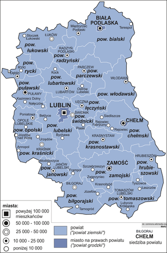
The Lublin Voivodeship is divided into 20 administrative districts and four urban districts. In addition to the voivodeship capital Lublin, three other cities have powiat status. They themselves do not belong to the districts of the same name (rural powiats).
Cities with powiat status
- Lublin (339,770)
- Zamość (63,511)
- Chełm (62,331)
- Biała Podlaska (57,264)
Powiaty (counties)
|
|
(Residents on June 30, 2019)
geography
Biggest cities
| city | Powiat | Residents June 30, 2019 |
|---|---|---|
|
|
circular | 339.770 |
|
|
circular | 63,511 |
|
|
circular | 62,331 |
|
|
circular | 57,264 |
|
|
Puławy | 47,634 |
|
|
Świdnik | 39,217 |
|
|
Kraśnik | 34,355 |
|
|
Łuków | 29,885 |
|
|
Biłgoraj | 26,309 |
|
|
Lubartów | 21,948 |
|
|
Tomaszów Lubelski | 19,050 |
|
|
Łęczna | 18,884 |
Rivers
The western boundary is the Vistula , the eastern boundary is the Bug . The Wieprz lies entirely within the province of Lublin.
National parks
The Polesie National Park, founded in 1990, is not far from the rural community of Gmina Urszulin in the powiat Włodawski and covers 97.62 square kilometers.
The Roztocze National Park has been located on the southern border of the voivodeship since 1974, with an area of 84.83 km² .
economy
The Lublin Voivodeship is one of the poorest regions in the EU . When compared with the EU GDP in terms of purchasing power standards , the voivodeship achieved an index of 47 in 2015 (EU-27 = 100). The unemployment rate in March 2019 was 8 percent, which corresponds to exactly 75,134 people. This is 2.1 percent more than the national average.
With a value of 0.834, Lublin ranks 8th among the 16 Voivodeships of Poland in the Human Development Index .
Extermination camp
In the area of the Lublin Voivodeship there are three former extermination camps in German-occupied Poland ( Generalgouvernement ):
Majdanek , Belzec , Sobibor and the former Izbica ghetto .
Web links
- Homepage of the Lublin Voivodeship (Polish, English, French)
Individual evidence
- ^ New voivode appointed. Retrieved February 15, 2017 (Polish).
- ^ Result of the 2011 census, Główny Urząd Statystyczny: Wyniki Narodowego Spisu Powszechnego Ludności i Mieszkań 2011. Warsaw, March 2012. Online ( Memento from January 16, 2013 in the Internet Archive ) (PDF)
- ↑ Krągły Goraj. Retrieved February 6, 2020 .
- ↑ population. Size and Structure by Territorial Division. As of June 30, 2019. Główny Urząd Statystyczny (GUS) (PDF files; 0.99 MiB), accessed December 24, 2019 .
- ↑ Eurostat. Retrieved April 15, 2018 .
- ↑ EURES European Job Mobility Portal ( Memento of April 2, 2015 in the Internet Archive )
- ^ Sub-national HDI - Area Database - Global Data Lab. Retrieved August 12, 2018 .
Coordinates: 51 ° 13 ' N , 22 ° 54' E


