
Lurais
| Lurais | ||
|---|---|---|
|
||
| region | Center-Val de Loire | |
| Department | Indre | |
| Arrondissement | Le Blanc | |
| Canton | Le Blanc | |
| Community association | Brenne-Val de Creuse | |
| Coordinates | 46 ° 42 ' N , 0 ° 57' E | |
| height | 67-134 m | |
| surface | 13.61 km 2 | |
| Residents | 249 (January 1, 2017) | |
| Population density | 18 inhabitants / km 2 | |
| Post Code | 36220 | |
| INSEE code | 36104 | |
| Website | www.communedelurais.com | |
_-_Mairie.jpg) Town Hall (Mairie) of Lurais |
||

Lurais is a western French community with 249 inhabitants (as of January 1 2017) in the department of Indre in the Region Center-Val de Loire . The municipality belongs to the Arrondissement of Le Blanc and the canton of Le Blanc (until 2015: canton of Tournon-Saint-Martin ). The inhabitants are called Luraisiens .
location
Lurais is located about 45 kilometers east-northeast of Poitiers on the Creuse . Lurais is surrounded by the neighboring communities of Néons-sur-Creuse in the north and north-west, Tournon-Saint-Martin in the north and north-west, Preuilly-la-Ville in the east, Fontgombault in the south and south-east, Mérigny in the south, Saint-Pierre-de- Maillé to the west and south-west and Angles-sur-l'Anglin to the west.
Population development
| year | 1962 | 1968 | 1975 | 1982 | 1990 | 1999 | 2006 | 2013 |
| Residents | 320 | 303 | 267 | 250 | 241 | 237 | 243 | 234 |
| Source: Cassini and INSEE | ||||||||
Attractions
- Saint-Jean church
- priory
- Montenault Castle
- Le Soudun Castle
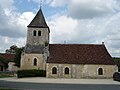
Saint-Jean church

priory

Le Soudun Castle
_-_%C3%89glise_Saint-Jean_-_vue_de_cot%C3%A9.jpg)

