Lignac
| Lignac | ||
|---|---|---|
|
|
||
| region | Center-Val de Loire | |
| Department | Indre | |
| Arrondissement | Le Blanc | |
| Canton | Saint-Gaultier | |
| Community association | Marche Occitane-Val d'Anglin | |
| Coordinates | 46 ° 28 ' N , 1 ° 13' E | |
| height | 104-197 m | |
| surface | 67.03 km 2 | |
| Residents | 459 (January 1, 2017) | |
| Population density | 7 inhabitants / km 2 | |
| Post Code | 36370 | |
| INSEE code | 36094 | |
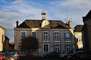
 Town hall (Mairie) of Lignac |
||
Lignac is a French municipality with 459 inhabitants (as of January 1 2017) in the department of Indre in the Region Center-Val de Loire ; it belongs to the Arrondissement of Le Blanc and the canton of Saint-Gaultier (until 2015: canton of Bélâbre ).
geography
Lignac is located about 49 kilometers southwest of Châteauroux on the Allemette River . Lignac is surrounded by the neighboring communities Chalais in the north, Prissac in the northeast, Dunet in the east, Chaillac in the southeast, Tilly in the south, Coulonges in the southwest, Thollet in the west and southwest, Liglet in the west and northwest and Bélâbre in the northwest.
Population development
| year | 1962 | 1968 | 1975 | 1982 | 1990 | 1999 | 2006 | 2013 |
| Residents | 1,057 | 992 | 809 | 706 | 614 | 572 | 572 | 538 |
| Source: Cassini and INSEE | ||||||||
Attractions
- Château-Guillaume castle from the 11th century, monument historique since 1862
- Saint-Christophe church from the 12th century with renovations from the 15th century
- 13th century church of Château-Guillaume
Web links
Commons : Lignac - collection of images, videos and audio files

