Magdalena (Laguna)
| Municipality of Magdalena | ||
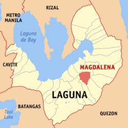
| Location of Magdalena in the province of Laguna | ||
|---|---|---|

|
||
| Basic data | ||
| Region : | CALABARZON | |
| Province : | Laguna | |
| Barangays : | 24 | |
| District: | 4. Laguna District | |
| PSGC : | 043415000 | |
| Income class : | 4. Income bracket | |
| Households : |
May 1, 2000 census
|
|
| Population : | 25,266 August 1, 2015 census
|
|
| Population density : | 724.4 inhabitants per km² | |
| Area : | 34.88 km² | |
| Coordinates : | 14 ° 12 ′ N , 121 ° 26 ′ E | |
| Postal code : | 4007 | |
| Geographical location in the Philippines | ||
|
|
||
Magdalena ( Tagalog : Bayan ng Magdalena ) is a Filipino municipality in the province of Laguna , in the administrative region IV, Calabarzon. It has 25,266 inhabitants (August 1, 2015 census) who lived in 24 barangays . It is classified as a fourth income class community in the Philippines and as partially urbanized .
Magdalena's neighboring communities are Majayjay in the south, Liliw in the southwest, Nagcarlan in the west, Pagsanjan in the north and Luisiana in the southeast. The topography of the city is characterized by rolling landscapes at the foot of the Banahaw volcano in the southwest and the foothills of the Sierra Madre in the east.
Barangays
|
|


