
Mardorf (Amöneburg)
|
Mardorf
City of Amöneburg
Coordinates: 50 ° 45 ′ 55 ″ N , 8 ° 55 ′ 1 ″ E
|
|
|---|---|
| Height : | 211 (210-236) m above sea level NHN |
| Area : | 13.48 km² |
| Residents : | 1587 (Jun 30, 2010) |
| Population density : | 118 inhabitants / km² |
| Incorporation : | December 31, 1971 |
| Postal code : | 35287 |
| Area code : | 06429 |
Mardorf is the largest district of Amöneburg in the central Hessian district of Marburg-Biedenkopf .
geography
The place is in the Amöneburg Basin in the Vorderen Vogelsberg .
history
The place was first mentioned in the document book of the Fulda monastery under the name Marachdorf , which is ascribed to the year 750 or 779.
Territorial reform
On December 31, 1971, the place was incorporated into the municipality of Amöneburg as part of the regional reform in Hesse .
Historical forms of names
In documents that have survived, Mardorf was mentioned under the following place names (the year it was mentioned in brackets):
- Marachdorf (750/779, based on a copy of the 12th century)
- Marcdorf (802/817, based on a 12th century copy)
- Marhdorf , in (1st half of the 9th century)
- Mardorf (1215)
- Martdorf (1227 and 1306)
- Marchtorf (around 1248)
- Marchtorph (around 1248)
- Mardorf (1323)
Territorial history and administration
The following list gives an overview of the territories in which Mardorf was located and the administrative units to which it was subordinate:
- before 1803: Holy Roman Empire , Electorate Mainz , Amöneburg office
- from 1803: Holy Roman Empire, Landgraviate of Hesse-Kassel (through Reichsdeputationshauptschluss ), Principality of Fritzlar , Amöneburg office
- from 1806: Electorate of Hesse , Principality of Fritzlar, Amöneburg office
- 1807–1813: Kingdom of Westphalia , department of Werra , district of Marburg , canton of Amöneburg
- from 1815: German Confederation , Electorate of Hesse, Amöneburg Office
- from 1821: German Confederation, Electorate of Hesse, Province of Upper Hesse , Kirchhain district
- from 1848: German Confederation, Electorate of Hesse, Marburg district
- from 1851: German Confederation, Electorate of Hesse, Province of Upper Hesse, Kirchhain district
- from 1867: North German Confederation , Kingdom of Prussia , Province of Hessen-Nassau , Administrative Region of Kassel , District of Kirchhain
- from 1918: German Empire, Free State of Prussia , Province of Hessen-Nassau, Administrative District of Kassel, District of Kirchhain
- from 1932: German Empire, Free State of Prussia , Province of Hessen-Nassau, Administrative Region of Kassel, District of Marburg
- from 1944: German Empire, Free State of Prussia, Province of Kurhessen , District of Marburg
- from 1945: American occupation zone , Greater Hesse , Kassel administrative district, Marburg district
- from 1949: Federal Republic of Germany , State of Hesse , Kassel district, Marburg district
- On December 31, 1971, the city of Amöneburg and the municipalities of Erfurtshausen, Mardorf, Roßdorf and Rüdigheim were merged to form the newly formed municipality of Amöneburg. The seat of the municipal administration is Amöneburg.
- 1974: Federal Republic of Germany, State of Hesse, Kassel district, Marburg-Biedenkopf district
- from 1981: Federal Republic of Germany, State of Hesse, Gießen district, Marburg-Biedenkopf district
population
Population development
Source: Historical local dictionary
| • around 1510: | 8 defensive men |
| • 1537: | 21 residents |
| • 1585: | 24 residents |
| • 1747: | 33 households |
| • 1838: | 926 inhabitants. 71 residents who are entitled to use, 88 residents who are not entitled to use, 33 residents |
| Mardorf: Population from 1834 to 1967 | ||||
|---|---|---|---|---|
| year | Residents | |||
| 1834 | 898 | |||
| 1840 | 934 | |||
| 1846 | 991 | |||
| 1852 | 1,019 | |||
| 1858 | 1,040 | |||
| 1864 | 1,028 | |||
| 1871 | 932 | |||
| 1875 | 962 | |||
| 1885 | 1.002 | |||
| 1895 | 940 | |||
| 1905 | 884 | |||
| 1910 | 903 | |||
| 1925 | 902 | |||
| 1939 | 1,018 | |||
| 1946 | 1,338 | |||
| 1950 | 1,353 | |||
| 1956 | 1,231 | |||
| 1961 | 1,223 | |||
| 1967 | 1,315 | |||
| Data source: Historical municipality register for Hesse: The population of the municipalities from 1834 to 1967. Wiesbaden: Hessisches Statistisches Landesamt, 1968. Other sources: | ||||
Religious affiliation
Source: Historical local dictionary
| • 1861: | 991 Roman Catholic, 4 Evangelical Lutheran , 36 Jewish residents |
| • 1885: | 9 Protestant (= 0.90%), 946 Catholic (= 94.41%) and 47 Jewish (= 4.69%) residents |
| • 1961: | 47 Protestant (= 3.84%), 1172 Roman Catholic (= 95.83%) residents |
Gainful employment
Source: Historical local dictionary
| • 1838: | Families: 60 agriculture, 50 trades, 49 day laborers |
| • 1961: | Labor force: 256 agriculture and forestry, 262 manufacturing, 20 trade and transport, 47 services and other. |
Culture and sights
- Fortified church with wall paintings
- a Junkernhof mentioned in 1223
- the church of St. Hubertus built around 1720 with the grotto built in 1908

The church
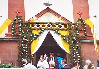
Local customs of Corpus Christi

So-called "honor gate"


Infrastructure
Public facilities
There are:
- a primary school , the St. Martin School
- a sports hall
- the Catholic Kindergarten St. Hubertus
traffic
The public transport is the bus services of the RMV ensured. State road 3289 runs through the village .
Web links
- District Mardorf on the website of the city of Amöneburg.
- Mardorf, Marburg-Biedenkopf district. Historical local dictionary for Hessen. In: Landesgeschichtliches Informationssystem Hessen (LAGIS).
- Literature about Mardorf in the Hessian Bibliography
Individual evidence
- ↑ a b c d e f g h Mardorf, Marburg-Biedenkopf district. Historical local dictionary for Hessen. (As of March 23, 2018). In: Landesgeschichtliches Informationssystem Hessen (LAGIS).
- ↑ The number comes from myheimat.de and is compatible with the value referenced at this point in time for the Erfurtshausen district from: Dorferneuerungsplan Erfurtshausen , August 2011 (PDF; 4.2 MB)
- ^ Federal Statistical Office (ed.): Historical municipality directory for the Federal Republic of Germany. Name, border and key number changes in municipalities, counties and administrative districts from May 27, 1970 to December 31, 1982 . W. Kohlhammer GmbH, Stuttgart / Mainz 1983, ISBN 3-17-003263-1 , p. 403 .
- ↑ Edmund Ernst Stengel u. a .: Document book of the Fulda Monastery 1 . The time of Abbots Sturmi and Baugulf. Ed .: Historical Commission for Hesse and Waldeck. No. 112 . Marburg 1958.
- ↑ Kopiar around 1160 Codex Eberhardi 1 , pp. 239–240, fol. 145 vb, no. 97 = Dronke, Traditiones, p. 39, Capitulum 6, no. 97.
- ^ Michael Rademacher: German administrative history from the unification of the empire in 1871 to the reunification in 1990. State of Hesse. (Online material for the dissertation, Osnabrück 2006).