
Nordhelle (Ebbegebirge)
| Nordhelle | ||
|---|---|---|
 View from Wellin south-south-west to Nordhelle |
||
| height | 662.7 m above sea level NHN | |
| location | between Reblin and Valbert ; Märkischer Kreis , North Rhine-Westphalia ( Germany ) | |
| Mountains | Ebbegebirge , Süderbergland | |
| Dominance | 28.1 km → Hoher Lehnberg ( Saalhauser Berge ) | |
| Notch height | 265 m ↓ northeast of Hollenseifen | |
| Coordinates | 51 ° 8 ′ 55 " N , 7 ° 45 ′ 24" E | |
|
||
| particularities | - highest mountain in the Ebbegebirge - Nordhelle transmitter - Robert-Kolb-Turm ( AT ) |
|


The northern light between Reblin and Valbert in the Märkisches Kreis in North Rhine-Westphalia is 662.7 m above sea level. NHN the highest mountain of the Ebbegebirge and the Märkisches Kreis. The Nordhelle transmitter and the Robert Kolb tower are located on the mountain .
geography
location
Nordhelle, located in the western Sauerland , rises roughly in the center of the Ebbegebirge in the Sauerland-Rothaargebirge Nature Park (formerly Ebbegebirge Nature Park ) in the municipality of Herscheid and in the urban area of Meinerzhagen . Its summit is about 200 m north of the Herscheid border with the Reblin district in the north and Meinerzhagen with the Valbert district in the south, which is at a maximum height of around 652 m . While the summit region and the northern parts of the mountain belong to the Herscheid district, the southern parts belong to the Valbert district. The east -south- east “Vorberg” of the Nordhelle is the Waldberg (approx. 638 m ) and its south-south-west neighbor is the Große Hahn ( 632.6 m ).
Natural allocation
The Nordhelle belongs to the natural spatial main unit group Süderbergland (No. 33), in the main unit Südsauerländer Bergland (336 2 ), its part Ebbe-Homert-Schwelle (336 2 .0-3) and in the subunit Ebbegebirge (336 2 .0) to the Hohes Ebbe natural area (336 2 .00).
Flowing waters
The Oester (Ebbebach) rises a little to the northwest of the Nordhelle and passes the mountain in the north to then pick up the Erlmecke swelling east of the mountain in the transition area to the Waldberg at Emmeszaun (Herscheid) . The Ihne tributary Schmale Becke (Homberger Bach) rises a little southwest of the Nordhelle in the transition area to the Großer Hahn .
Protected areas
Parts of the nature reserve (NSG) Auf'm Ebbe / Ebbemoore ( CDDA -Nr. 162294; 1930 designated; 6.664 km² in size) extend to the southern high elevations of the Nordhelle , on the eastern flank is the NSG Wolfsbruch (CDDA-Nr. 82939; 1930 ; 16.97 ha ), on the western flank the Brauke NSG (CDDA no. 318232; 1995; 9.41 ha) and in the south-west the Kammmoor NSG (CDDA no. 318628; 1995; 2.64 ha). Parts of the landscape protection area (LSG) sub-area Plettenberg-Herscheid-Neuenrade (CDDA no. 555555100; 1985; 87.308 km²) extend to the summit region and, up to the southern flank, those of LSG Meinerzhagen - type A (CDDA no. 555555265; 2001; 84.2604 km²). Parts of the fauna-flora-habitat area Ebbemoore (FFH no. 4812-301; 10.69 km²) extend to the southern highlands .
Towers
Transmission towers
The 130 m high WDR transmission tower of the Nordhelle transmitter is located on the summit area of the Nordhelle and about 215 m northeast of it is a telecommunications tower of the Bundeswehr , which is designed as a reinforced concrete tower and is used for mobile communications . About 1.2 km east-southeast of the mountain peak is the Ebbegebirge telecommunications tower on the Waldberg , which was called "Sender Lüdenscheid" until the introduction of DVB-T.
Robert Kolb Tower
On the summit region of the Nordhelle there is also the Robert Kolb Tower observation tower , about 50 m northwest of the WDR transmission tower , an observation tower with a glazed observation platform, from which a view to the north and south-west is possible. Is located on the turret roof an amateur radio - relay station with the call sign DB0MKV.
Transport and leisure
The state road 707 runs between Herscheid and Valbert over the western high elevations of the Nordhelle, approximately in a north-south direction. Starting at two parking spaces near the Kammmoor above the 600 m contour line , which are on or near the road the summit region can be reached after a short walk. The Lenne-Sieg-Weg , Richard-Schirrmann-Weg , Robert-Kolb-Weg and Sauerland-Höhenflug run over the mountain . On its northern flank, above the Herscheider hamlets Ebbefeld and Daum , there were three ski lifts with slopes until 2009 ; Since the lifts were dismantled, the former departure area has been used by paragliders.
gallery
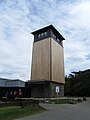
Robert Kolb Tower (observation tower)

WDR tower of the
station Nordhelle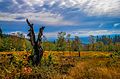
Autumn near the northern light


.jpg)
Individual evidence
- ↑ a b c Topographical Information Management, Cologne District Government, Department GEObasis NRW ( information )
- ↑ dominance and prominence according to TK 25; Scharte is about 398 m above sea level on the Bigge - Wisser Bach -Wasserscheide, near the Bigge
- ↑ Map services of the Federal Agency for Nature Conservation ( information )
- ↑ Andreas Wolf: Lift operation is discontinued. In: Westfälische Rundschau . DerWesten.de , September 9, 2009, accessed on May 11, 2015 .
- ↑ Ski slope Ebbefeld / Nordhelle paraglider. In: dhv.de. German Hang Glider Association , accessed on May 11, 2015 .