Vendsyssel-Thy
| Vendsyssel-Thy (North Jutian Island) |
|
|---|---|
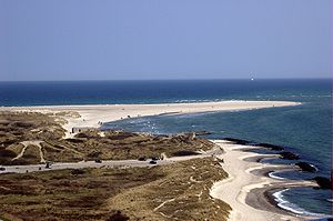
| Grenen , the northern tip of the island | |
| Waters | Skagerrak / Limfjord / Kattegat / North Sea |
| Geographical location | 57 ° 17 ' N , 10 ° 3' E |
| length | 194 km |
| width | 71 km |
| surface | 4th 685.73 km² |
| Highest elevation | Knøsen 136 m |
| Residents | 294,424 (January 1, 2020) 63 inhabitants / km² |
| main place | Hjørring |
| map | |
Vendsyssel-Thy (after the landscapes Vendsyssel and Thy ) or North Jutland Island ( Danish Nørrejyske Ø ) is the northernmost part of Jutland . The area is separated from the Jutian peninsula in the south by the Limfjord ; however, it did not become an island until 1825.
In common parlance, the area is understood neither as an island nor as a whole, but rather as the three traditional areas Thy , Hanherred and Vendsyssel . The name North Jutland also includes the island of Mors and the Himmerland region south of the Limfjord. The Danes also use the adjective nordenfjords ("north of the fjord") about the area .
Emergence
From around 1100 until the February flood in 1825 , the island was still connected to the mainland and is still rarely considered an island in general perception . It is the second largest island in Denmark with an area of 4685.73 km² . It has a population of 294,424 (January 1, 2020).
Classification and administration
In terms of cultural geography, Vendsyssel-Thy is always regarded as part of Jutland. Like the neighboring islands of Mors , Læsø , Hirsholmene , Livø and the Himmerland region south of the fjord, the area has belonged to the administrative region of Nordjylland since 2007 .
For Administrative Region Midtjylland , however, belongs to the southern foothills of Thy, Thyholm .
geography
Cities and larger towns:
- Vendsyssel: Hjørring , Frederikshavn , Skagen , Brønderslev , Sæby , Hirtshals , Løkken and Nørresundby (part of Ålborg Municipality)
- Hanherred: Fjerritslev , Brovst
- Thy: Thisted , Hanstholm , Hurup , Hvidbjerg
On spits Grenen in Skagen encounter Skagerrak and Kattegat each other.
The highest point on the island is the 136 meter high Knøsen north of the village of Dronninglund. Right next to it is Knaghøj, which reaches almost the same height. These hills are located on the ridge of Jyske Ås , which extends over a length of 25 km and has further elevations over 100 meters: Allerup Bakker, Storstensbakken, Voldene and Skelbakken.
Transport links
Road and rail traffic
The following fixed crossings exist from west to east:
- Oddesundbroen - road and rail bridge over Oddesund near Struer
- Vilsundbroen - road bridge over Vilsund to the island of Mors (and from there over the Sallingsund bridge to the Jutian "mainland")
- Aggersundbroen - road bridge to Himmerland in the middle of the Limfjord
- Railway bridge over the Limfjord in Aalborg
- Limfjordsbroen - road bridge, connects the district of Nørresundby with the center of Ålborg
- Limfjord Tunnel - E45 motorway tunnel in Ålborg
A western link in Ålborg, the so-called Third Limfjord Connection ( den tredje limfjordsforbindelse ) has been in the planning process for many years.
Shipping
Car ferries run across the Limfjord:
- Thyborøn – Agger
- Neessund (near Hurup from Thy to Mors)
- Feggesund (near Vesløs from Hannæs to Mors)
- Ålborg to Egholm Island
- Hals –Egense at the eastern opening of the Limfjord
North ferries from Hirtshals Havn to Norway, the Faroe Islands and Iceland. Ferries to Norway and Sweden run from Frederikshavn . There used to be ferries from Hanstholm to Kristiansand / Mandal / Egersund / Bergen (Norway) and briefly Skagen- Marstrand (Sweden).
Until the early 19th century, steamboats connected the cities along the Limfjord, such as Ålborg, Løgstør, Thisted, Struer, Nykøbing and Skive. These ran until a few decades after the railway network was expanded. The night ferry Ålborg – Copenhagen was an important part of Danish inland traffic from 1936 to September 30, 1970; there was the possibility of changing passengers at Hals.
See also
Web links
Individual evidence
- ↑ a b statistics banks -> Befolkning og valg -> BEF4: Folketal pr. January 1st demands på øer (Danish).
- ↑ Danmarks Statistics : Statistical Yearbook 2009 - Geography and climate, Table 3 Area and population. Regions and inhabited islands (English; PDF file; 38 kB)
- ↑ Transport Minister wants to build more roads , Der Nordschleswiger , February 14, 2018


