Gornji Petrovci
|
Gornji Petrovci Petersberg |
|||
|
|||
| Basic data | |||
|---|---|---|---|
| Country |
|
||
| Historic region | Übermurgebiet / Prekmurje | ||
| Statistical region | Pomurska (Mur region) | ||
| Coordinates | 46 ° 48 ' N , 16 ° 13' E | ||
| surface | 66.8 km² | ||
| Residents | 2,057 (2016) | ||
| Population density | 31 inhabitants per km² | ||
| Post Code | 9203 | ||
| License Plate | MS | ||
| Structure and administration | |||
| Mayor : | Franc Šlihthuber | ||
| Website | |||
Gornji Petrovci (German Petersberg ; Hungarian : Péterhegy ) is a municipality and a village in Goričko , the hilly part of the historical Prekmurje region (German: Übermur, also Transmurien ) in Slovenia .
geography
The municipality occupies the northern part of the Goričko hills and ravines and, with two districts, touches the border with Hungary . The municipality extends over an area of 66.84 km² and borders in the north on the Hungarian county Vas (German: Eisenburg ), in the east on the municipality Šalovci (German: Schabing ), in the southeast on the municipality Moravske Toplice (German: Olsnitz ), in the south and southwest to the municipality of Puconci (German: Putzendorf ), in the west to the municipality of Grad (German: Oberlimbach ) and in the northwest to the municipality of Kuzma (German: Sankt Cosmas ).
The municipality includes the headwaters and upper reaches of the waters of the Koritiški, Merak, Peskovski and Mala Krka brooks, which flow from west to east, with heights of around 260 m. Most of the gently rising hills and crests between the lowlands are forested. The highest elevation of the community with 404 m is the Srebni breg, the Silberberg, on the watershed between Mur and Raab, directly on the Hungarian border. Other pronounced hills in the municipality are: Sveta Ana (Sankt-Anna-Berg) 395 m, Huma 362 m, Majorce 364 m and Nedelski breg 355 m, the historic Sunday mountain with its wonderful view, above the community center. The entire municipality belongs to the three-country park Raab-Goričko-Örseg .
The municipality has approx. 2250 inhabitants and is made up of 14 localities, which are represented in the municipality's coat of arms as blue houses with red roofs.
Localities of the municipality of Gornji Petrovci
| Slovenian name | Prekmurian name | German name | Hungarian name | Population (2016) | image |
|---|---|---|---|---|---|
| Adrijanci | Adrijance | Small sound | Andorháza, formerly Adriáncz | 146 |

|
| Boreča | Boriče | Saint Anna | Borháza | 84 |

|
| Košarovci | Košarovce | Basket house | Kosárháza | 74 |

|
| Gornji Petrovci | Gorenji Petrovci | Petersberg | Péterhegy, formerly Felső-Petrócz | 405 |

|
| Križevci ; before 1952 Križevci v Prekmurju | Križevci | Holy cross | Keresztúr, formerly Tótkeresztúr | 374 |

|
| Kukeč | Kükeč, formerly Kükečko | Küketsch | Újkökényes | 57 | |
| Lucova | Lücova | Lychow (obsolete) | Lakháza | 113 | |
| Martinje | Martinje | Martini | Magasfok | 110 |

|
| Neradnovci | Maranovci | Nadorf, also Neudorf | Nádorfa | 140 |

|
| Panovci | Pananovci | Saint Johann | Úriszék, formerly Pananócz | 32 |

|
| Peskovci | Peskouvci | Henzensdorf | Petőfa, formerly Peszkócz | 75 |

|
| Stanjevci | Stanjevce | Perchtenstein | Kerkaszabadhegy, formerly Sztanyócz | 181 |

|
| Šulinci | Šülinci | Sulintz | Sándorvölgy, formerly Sztanyócz or Sülincz | 160 | |
| Ženavlje | Ženavlje | Schönabla | Gyanafa | 107 |
history
A first settlement is mentioned in 1385 as Oberdorf , which was owned by the Hencherfalua family. In 1431 the Hungarian name Petrocz appears for the first time , in 1448 Petrolcz , 1467 Petróczi . After the Hencherfalua family died out in the 16th century, the place came to the Széchy family . After their extinction, the village fell to the Counts of Nádasdyaké in 1685.
In the second half of the 16th century, the residents took over the Reformation; only in 1642 was a Catholic parish founded again.
Up to the 20th century, the municipality was divided into two parts, Felső-Petrócz (Oberpetersberg) and Mura Petrócz (Murpetersberg). In the second half of the 19th century, the Counts Batthyáni with Mura Petrócz acquired the southern part, the Counts Nádasdy with Felső-Petrócz the northern part, both of whom remained landlords until the end of the First World War. In 1910 the majority of the population was Slovenes, with a significant Hungarian minority. On May 29, 1919 Gornji Petrovci became part of the Mur republic and then came under the Treaty of Trianon - like almost the entire Übermur area - to the Kingdom of Yugoslavia . In April 1941 Hungary declared war on Yugoslavia and occupied the Übermur area. In 1945 the community came back to Yugoslavia; In 1991 it became part of the Republic of Slovenia. The municipality in its current form was established on October 3, 1992, when the area was spun off from the municipality of Murska Sobota and became independent.
Culture
The most important cultural monuments of the community include the following churches:
Holy Spirit Church
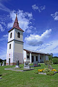
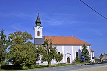
The parish church "Heilig-Geist" (Slovenian cerkev Sveta Trojica ) in Gornji Petrovci was built at the end of the 13th century and stands on Romanesque foundations. The nave is also late Romanesque. A major expansion in the Gothic style took place in the 15th century with a late Gothic presbytery. Around 1642 the interior was redesigned in Baroque style. The bell tower was not added until 1675. There are two bells in it: the Saint Medardus bell weighing 440 kg from 1675, and the larger Marien bell weighing 624 kg, cast in 1924. Protestant services were held in the church from 1592 to 1732; it was not until 1733 that she became Catholic again. See picture above under "Locations of the municipality of Gornji Petrovci".
Evangelical Church in Gornji Petrovci
The Evangelical Church (Slovene: Evangeličanska cerkev ) in Gornji Petrovci is one of the largest Evangelical churches in the Übermur area. It is 22 m long and 4 m wide and was built in 1804 as a single-nave church with a gallery and a bell tower. In 1894 it was renovated and converted by the architect Daniel Placotta. The church became known nationwide when the first female priestess in Slovenia began her service here in 1984.
Saint Anne Church
The pilgrimage church from the 16th century is located in the district of Boreča. See picture above under "Locations of the municipality of Gornji Petrovci".
Evangelical Church in Križevci
The Evangelical Church (Slovenian: Evangeličanska cerkev ) in Križevci stands on the highest elevation in the area, the Vrey (390 m) and was built in 1795 (according to other sources, 1785) and is therefore the oldest Evangelical church in the Übermur area. In 1885 the church was enlarged by four meters and rebuilt in the style of historicism . In 1982 a complete renovation took place.
More cultural monuments
At Ženavlje there are two Roman burial mounds that have not yet been archaeologically examined. There are other burial mounds in the forest near Križevci. Remnants of a Roman settlement were discovered near Peskovci. Traces of a prehistoric settlement have been found near Lukova. In Neradnovci on the Mala Krka stream is the Lenarčičev mill from 1870. In 2000 the mill was completely renovated and is back in operation.
Goričko Museum of Old Agricultural Tools and Technology
The museum in Adrijanci (Slovenian: Muzej starih kmetijskih orodji in motorne tehnike Goričko ) shows artefacts from rural life in Prekmure, as well as a collection of vintage cars.
climate
The climate is temperate continental with cool winters and hot summers. The coldest month is January with an average temperature of −1.5 ° Celsius, the warmest month is July with an average temperature of 20 ° Celsius. Over the year the average rainfall is 900 mm; the rainiest month is July.
Others
- Gornji Petrovci is one of the few municipalities in Slovenia where the majority of the population belongs to the Evangelical Lutheran faith. Most parishes have a Catholic majority.
- On August 18, 1934, Belgian aviation pioneers and balloonists Max Cosyns and Nérée van der Elst crashed their stratospheric balloon near Gornji Petrovci. To commemorate this event, August 18th is the local holiday.
Personalities
- Matjaž (Mátyás) Godina (1768 in Gornji Petrovci - † January 1, 1835 in Gornji Petrovci), Protestant priest and teacher; Composer and writer in the Prekmurian language
- József Ficzkó (born March 15, 1772 in Boreča, † November 28, 1843 in Peresznye), Burgenland-Croatian writer and Catholic priest.
- Mikola Sándor (born April 16, 1871 in Gornji Petrovci - † October 1, 1945 in Nagykanizsa ); Physicist, educator, member of the Hungarian Academy of Sciences
- Milan Kučan (born January 14, 1941 in Križevci), from 1986 to 1990 chairman of the Communist Party of Slovenia ; from 1991 to 2002 the first President of the Republic of Slovenia .
literature
- Ivan Zelko , Historična Topografija Slovenije I. Prekmurje do leta 1500. Murska Sobota, 1982.
- Matija Slavič, Naše Prekmurje. Murska Sobota, 1999.
- Atlas Slovenije, Ljubljana 1985.
Web links
Individual evidence
- ↑ Statistični urad Republike Slovenije from June 6, 2016.
- ↑ Ivan Zelko: Historična Topografija Slovenije I. Prekmurje do leta 1500 ( Historical Topography of Slovenia to 1500, Part I Prekmurje ); Murska Sobota, 1982
- ↑ Jernej Vengušt: Seznamek prekmurskih občin (krajev) z označbo pošte in zemljevidom ( municipalities and towns in the Übermur area with postal names and maps ), p. 3 Radgona, 1919
- ↑ András Vályi: Magyar Országnak leírása ( Description of the Hungarian landing ); Buda, 1796.
- ↑ Dezső Csánky: Magyarország történelmi földrajza a Hunyadiak korában ( Historical Geography of Hungary at the Time of Hunyadis ); Budapest, 1890.
- ↑ Jernej Vengušt: Seznamek prekmurskih občin (krajev) z označbo pošte in zemljevidom ( municipalities and towns in the Übermur area with postal names and map ), p. 4, Radgona, 1919
- ↑ Viktor Lumtzer, Johann Melich: German place names and loanwords of the linguistic treasure. Sources and research on the history, literature and language of Austria and its crown lands . Publishing house of the Wagner University Bookstore, Innsbruck 1900.
- ↑ Jernej Vengušt: Seznamek prekmurskih občin (krajev) z označbo pošte in zemljevidom ( municipalities and towns in the Übermur area with postal names and maps ), p. 8, Radgona, 1919
- ↑ Jernej Vengušt: Seznamek prekmurskih občin (krajev) z označbo pošte in zemljevidom ( municipalities and towns in the Übermur area with postal names and maps ), p. 12, Radgona, 1919
- ↑ András Vályi: Magyar Országnak leírása ( Description of the Hungarian landing ); Buda, 1796.
- ↑ spremembe naselij ( change of the settlement names ) 1948-95 . 1996. Database. Ljubljana: Geografski inštitut ZRC SAZU, DZS.
- ↑ Jernej Vengušt: Seznamek prekmurskih občin (krajev) z označbo pošte in zemljevidom ( municipalities and towns in the Übermur area with postal names and maps ), p. 8, Radgona, 1919
- ↑ András Vályi: Magyar Országnak leírása ( "Description of the Hungarian land"); Buda, 1796.
- ↑ Jernej Vengušt: Seznamek prekmurskih občin (krajev) z označbo pošte in zemljevidom ( municipalities and towns in the Übermur area with postal names and map ), p. 10, Radgona, 1919
- ↑ Dezső Csánky: Magyarország történelmi földrajza a Hunyadiak korában ( Historical Geography of Hungary at the Time of Hunyadis ); Budapest, 1890.
- ↑ Samu Borovszky et al. János Sziklay in: Országos Monografia Társaság 1896–1914; Budapest.
- ↑ Dezső Csánky: Magyarország történelmi földrajza a Hunyadiak korában ( Historical Geography of Hungary at the Time of Hunyadis ); Budapest, 1890.
- ↑ Jernej Vengušt: Seznamek prekmurskih občin (krajev) z označbo pošte in zemljevidom ( municipalities and towns in the Übermur area with postal names and map ), p. 10, Radgona, 1919
- ↑ Mikola, István et al. Ferenc Mikola: Zahválnoszt. Düsevni liszt: Mêszecsne verszke novine of August 20, 1924; Pp. 116-117; Budapest
- ↑ Jernej Vengušt: Seznamek prekmurskih občin (krajev) z označbo pošte in zemljevidom ( municipalities and towns in the Übermur area with postal names and map ), p. 11, Radgona, 1919
- ↑ András Vályi: Magyar Országnak leírása ( Description of the Hungarian landing ); Buda, 1796.
- ↑ Jernej Vengušt: Seznamek prekmurskih občin (krajev) z označbo pošte in zemljevidom ( municipalities and towns in the Übermur area with postal names and map ), p. 11, Radgona, 1919
- ↑ Samu Borovsky: Magyaroszág vármegyéi it városai ( counties and cities of the Kingdom of Hungary ), Buda.
- ↑ Dezső Csánky: Magyarország történelmi földrajza a Hunyadiak korában ( Historical Geography of Hungary at the Time of Hunyadis ); Budapest, 1890.
- ↑ Jernej Vengušt: Seznamek prekmurskih občin (krajev) z označbo pošte in zemljevidom ( municipalities and towns in the Übermur area with postal names and maps ), p. 12, Radgona, 1919
- ↑ András Vályi: Magyar Országnak leírása ( Description of the Hungarian landing ); Buda, 1796.
- ↑ Dezső Csánky: Magyarország történelmi földrajza a Hunyadiak korában ( Historical Geography of Hungary at the Time of Hunyadis ); Budapest, 1890.
- ↑ Jernej Vengušt: Seznamek prekmurskih občin (krajev) z označbo pošte in zemljevidom ( municipalities and towns in the Übermur area with postal names and map ), p. 7, Radgona, 1919
- ↑ Dezső Csánky: Magyarország történelmi földrajza a Hunyadiak korában ( Historical Geography of Hungary at the Time of Hunyadis ); Budapest, 1890.
- ↑ Samu Borovszky et al. János Sziklay: Magyarország vármegyéi és városai: Magyarország monografiája. Országos Monografia Társaság. Budapest: Országos Monografia Társaság, ( Monograph on the towns and districts of the Hungarian Crown ), Budapest, 1896–1914.
- ↑ András Vályi: Magyar Országnak leírása ( Description of the Hungarian landing ); Buda, 1796.
- ↑ Jernej Vengušt: Seznamek prekmurskih občin (krajev) z označbo pošte in zemljevidom ( municipalities and towns in the Übermur area with postal names and maps ), p. 13, Radgona, 1919
- ↑ Dezső Csánky: Magyarország történelmi földrajza a Hunyadiak korában ( Historical Geography of Hungary at the Time of Hunyadis ); Budapest, 1890.
- ↑ Elek Fényes: Magyarország geographiai szótára, mellyben minden város, falu és puszta, beürendben körülményesen leiratik ( Geographical Dictionary of Hungary ); Pest, 1851.
- ↑ Samu Borovszky et al. János Sziklay: Magyarország vármegyéi és városai: Magyarország monografiája. Országos Monografia Társaság. Budapest: Országos Monografia Társaság, ( Monograph on the towns and districts of the Hungarian Crown ), Budapest, 1896-1914.
- ↑ András Vályi: Magyar Országnak leírása ( Description of the Hungarian landing ); Buda, 1796.
- ↑ Dezső Csánky: Magyarország történelmi földrajza a Hunyadiak korában ( Historical Geography of Hungary at the Time of Hunyadis ); Budapest, 1890.
- ↑ András Vályi: Magyar Országnak leírása ( Description of the Hungarian landing ); Buda, 1796.
- ^ Statistical Office of the Republic of Slovenia. 2007. Vzpostavitev Lokalne samouprave v Republiki Sloveniji v številkah, no.6 .
- ↑ Archive link ( Memento of the original from July 22, 2017 in the Internet Archive ) Info: The archive link was inserted automatically and has not yet been checked. Please check the original and archive link according to the instructions and then remove this notice. Ministry of Culture of Slovenia; Register of Immovable Cultural Heritage, No. ešd 2997.
- ↑ Archive link ( Memento of the original from July 22, 2017 in the Internet Archive ) Info: The archive link was inserted automatically and has not yet been checked. Please check the original and archive link according to the instructions and then remove this notice. Ministry of Culture of Slovenia; Register of Immovable Cultural Heritage, No. ešd 4148.
- ↑ Archive link ( Memento of the original from July 22, 2017 in the Internet Archive ) Info: The archive link was inserted automatically and has not yet been checked. Please check the original and archive link according to the instructions and then remove this notice. Ministry of Culture of Slovenia; Register of Immovable Cultural Heritage, No. ešd 4148.
- ↑ Archive link ( Memento of the original from July 22, 2017 in the Internet Archive ) Info: The archive link was inserted automatically and has not yet been checked. Please check the original and archive link according to the instructions and then remove this notice. Slovenian. Ministry of Culture; Register of Immovable Cultural Heritage, No. ešd 6785; 13689; 29508; 6772.


