Phoenix Islands
| Phoenix Islands | |
|---|---|
| Waters | Pacific Ocean |
| Geographical location | 3 ° 40 ′ S , 172 ° 20 ′ W |
| Number of islands | 8 atolls |
| Main island | Canton |
| Total land area | 27.77 km² |
| Residents | 20 (2015) |
| Location of the individual atolls, reefs and seamounts | |
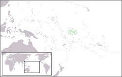
The Phoenix Islands (Rawaki Islands) group is one of three archipelagos in the island state of Kiribati in the central Pacific Ocean . The archipelago lies south of the equator , north of Samoa , east of the Gilbert and Ellice Islands and west of the Line Islands . It consists of eight (mostly) uninhabited, widely scattered atolls , which together are almost 28 km² in size, as well as two separate coral reefs that are constantly flooded and have no land areas. The area does not include the large lagoons (the largest is the lagoon of Canton with around 50 km²), but only those lagoons that are completely cut off from the sea and therefore represent inland waters. The German geographer Karl Eduard Meinicke also counted the US territories of Baker Island and Howland Island, a few hundred kilometers to the northwest, to the Phoenix Islands.
The eight atolls are: Map with all coordinates: OSM | WikiMap![]()
| Atoll / island / reef | Island km² |
Lagoon km² |
Coordinates | |
|---|---|---|---|---|
|
Phoenix Islands (Kiribati) |
||||
| Canton (Abariringa, Swallow) | 9.0 | 50 | 2 ° 50 ′ S , 171 ° 43 ′ W. | |
| Enderbury | 5.1 | * 0.6 | 3 ° 8 ′ S , 171 ° 5 ′ W | |
| Birnie (Birney) | 0.2 | * 0.02 | 3 ° 35 ′ S , 171 ° 31 ′ W | |
| McKean | 0.57 | * 0.2 | 3 ° 36 ′ S , 174 ° 8 ′ W. | |
| Rawaki (Phoenix Island) | 0.5 | 0.5 | 3 ° 43 ′ S , 170 ° 43 ′ W | |
| Manra (Sydney Island) | 4.4 | * 2.2 | 4 ° 27 ′ S , 171 ° 15 ′ W | |
| Orona (Hull Island) | 3.9 | 30th | 4 ° 30 ′ S , 172 ° 10 ′ W | |
| Nikumaroro (Gardner Island) | 4.1 | 4th | 4 ° 40 ′ S , 174 ° 31 ′ W | |
| Phoenix Islands | 27.77 | 84.5 | ||
|
Flooded coral reefs |
||||
| Winslow Reef | - | 1 | 1 ° 36 ′ S , 174 ° 57 ′ W. | |
| Carondelet Reef | - | ? | 5 ° 34 ′ S , 173 ° 51 ′ W. | |
In 1889 the Phoenix Islands came into British possession. The atolls Canton and Enderbury were co-administered as US military bases by the United States from 1939 ( condominium ). The settlement was abandoned after the dry season from 1955 to 1964. The archipelago has belonged to the island state of Kiribati since 1979. In 2006, the Phoenix Islands and the marine area surrounding them were declared a Phoenix Islands Protected Area (PIPA) by the Kiribati government , the area of which was expanded to over 410,000 km² on January 28, 2008. In August 2010 the nature reserve was added to the UNESCO World Heritage List .
See also
- Phoenix Islands Settlement Scheme (unsuccessful settlement attempt in 1938)
- Guano Islands Act , US law (1856), which legitimized the mining of guano by the USA
Web links
- Map of the Phoenix Islands (English)
- The South Sea Islands from Droysen's General Historical Handbook; 1886, ct. 85a
- Homepage of the Phoenix Islands Protected Area (English)
Individual evidence
- ↑ [1]
- ↑ Mariana Variety, August 11, 2010 ( page no longer available , search in web archives ) Info: The link was automatically marked as defective. Please check the link according to the instructions and then remove this notice.

