
Pieterburen
| province |
|
| local community |
|
|
Area - land - water |
0.69 km 2 0.68 km 2 0.01 km 2 |
| Residents | 300 (Jan. 1, 2017) |
| Coordinates | 53 ° 24 ' N , 6 ° 27' E |
| prefix | 0595 |
| Postcodes | 9723, 9967-9969, 9977 |
 |
|
Pieterburen (in Groningen dialect Paiderboeren ) is a place in the municipality of Het Hogeland in the province of Groningen in the northeast of the Netherlands . The place has 300 inhabitants (as of January 1, 2017).
Pieterburen was first mentioned in a document in the 14th century. This is what a passage in a document from 1371 reads “ de parochianen van Sint Pieter in het nieuwe land ”. The first ecclesiastical mention of Pieterburen dates from 1448 . In 1990 the place became part of the large municipality of De Marne and was administered from the seat of the municipality in Leens until 2019 . Since then it has been part of the municipality of Het Hogeland.
geology
The place is located on the so-called Hogeland , a region close to the coast, which over the millennia has grown a few meters above the regions of the surrounding area due to siltation, sedimentation , storm surges and scorch formation . The estuary of the Hunze was a long time ago near Pieterburen. Today the (now canalised ) Hunze flows from the geological changes mentioned under the name Reitdiep into the Lauwersmeer . Pieterburen lies exactly above a mighty pyramid-shaped salt dome that begins at a depth of 218 m. It was measured in 1976 and 2011 by drilling and seismic exploration and should possibly be used as a natural gas storage facility. It was also discussed as a storage facility for radioactive waste.
The gas production in the Groningen area repeatedly results in tremors that also damage houses.
The surrounding fertile agricultural land ( clay soils ) is cultivated by five farms.
Culture
Approximately north of the village was the Borg Dijksterhuis , a castle-like villa building ("Borg") that was demolished in 1903 . The demolition material was used for building Pieterburen's houses, among other things.
Attractions
- the Pieterburen seal sanctuary
- The Gothic Petruskirche with a Schnitger organ and carvings by Allert Meijer and Jan de Rijk
- The botanical garden Domies Toen (in German about "Pfarrgarten") with a Fething (rainwater collection basin) from 1300.
- The De Vier Winden grain and peeling mill from 1846. Today the mill is used as a training mill for volunteer millers .
- In 2007 there was a renewal of the village . The main street that leads through the village (see also street village ) was renewed and a multi-purpose square was created. The Martenspad was paved and is now a cycle path from Pieterburen to the nearby Wadden Sea .
gallery
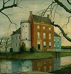
Former Dijksterhuis Castle near Pieterburen

The Petruskirche of Pieterburen

The former Reformed Church


sport and freetime
- The village is a starting and finishing point for mudflat hikers .
- The place is also the starting point of the 490 km long long- distance hiking trail "Pieterpad", which runs from here to Pietersberg near Maastricht .
- The European long-distance hiking trail E9 , at this point also known as the 'North Sea Trail of the Wadden and Warften Path ' (Dutch “Wad en Wierdenpad”), runs through the village .
literature
- Art. Pieterburen . In: Wiebe Jannes Formsma, Riektje Annie Luitjens-Dijkveld Stol, Adolf Pathuis: De Ommelander borgen en steenhuizen . Van Gorcum, Assen 1973, ISBN 90-232-1047-6 , pp. 330-337.
Web links
- Seal sanctuary website (Dutch, German)
Individual evidence
- ↑ a b Kerncijfers wijken en buurten 2017 Centraal Bureau voor de Statistiek , accessed on June 27, 2018 (Dutch)
- ↑ Possible alternatives to the storage of gas in the Pieterburen salt dome ( Memento of the original of September 9, 2017 in the Internet Archive ) Info: The archive link was automatically inserted and not yet checked. Please check the original and archive link according to the instructions and then remove this notice. PDF 1.6 MB (Dutch)
- ↑ Pieterburen zoutpijler (Pieterburen salt dome) ( Memento of the original from September 9, 2017 in the Internet Archive ) Info: The archive link has been inserted automatically and has not yet been checked. Please check the original and archive link according to the instructions and then remove this notice. PDF 2 MB (Dutch)
- ^ Nuclear waste on the move , April 2010
- ↑ Gas production in Groningen triggers earthquake , in "Die Welt" on November 13, 2015