Röda linjen (Stockholm)
| Red line | |
|---|---|
|
Station stadium
| |
|
Röda linjen plan
| |
| Route length: | 39.7 km |
| Gauge : | 1435 mm ( standard gauge ) |
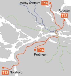
Röda linjen ( German Red Line ), internally Tub 2 , is the collective term for two underground lines of the Stockholm tunnelbana . The Röda linjen consists of lines T13 and T14. They connect areas in the north of the city with those in the south-west. There are two branches on both sides of the route. Although the line numbers exist formally, appear on timetables and are displayed on the train destination displays on the platforms, they are rarely used in the population. Since the trains of the two lines in the section between Östermalmstorg and Liljeholmen share a common section, they are summarized under the umbrella term Red Line . This trunk section between the Östermalmstorg and Liljeholmen stations is particularly short compared to the outer branches as well as to the two other line systems of the Stockholm subway. Röda Linjen have a total of 36 access points, 19 of which are underground. The route is 39.7 kilometers long. The first section of the line between the stations T-Centralen and Örnsberg (T13) and Fruängen (T14) was opened on April 5, 1964.
Line T13 begins at Ropsten station in the northeast, and runs south to Östermalmstorg station. From there it runs together with the T14 line to Liljeholmen station. There the two lines separate again and the T13 continues in a south-westerly direction to the terminus Norsborg, which is far outside. The T14 line starts at the Mörby-centrum station in the north of Stockholm and runs in a southerly direction to Östermalmstorg station, from where it runs together with the T13 line under the center of Stockholm to Liljeholmen station. Here the T14 branches off towards the south to its end point in Fruängen . In 2005, the two lines were used by around 411,000 travelers on working days.
There is only one depot, the Nyboda depot, on the Röda linjen routes . It is connected to Liljeholmen station via a double-track, partly in the tunnel, operating line and, like most Stockholm underground depots, offers the only options for turning train units for even tire and wheel flange wear.
history
The red line was the second main line of the Stockholm Metro, after the green line, which was essentially completed in 1960. It was opened in the following stages:
- 1956: Telephone plan - Fruängen, at the opening traffic with trams
- 1964: T-Centralen - Fruängen, as a subway
- 1964: Liljeholmen - Örnsberg
- 1965: Örnsberg - Sätra
- 1965: T-Centralen - Östermalmstorg
- 1967: Sätra - Skärholmen
- 1967: Östermalmstorg - Ropsten
- 1967: Skärholmen - Vårberg
- 1972: Vårberg - Fittja
- 1973: Östermalmstorg - Tekniska Högskolan
- 1975: Tekniska Högskolan - Universitetet
- 1975: Fittja - Norsborg
- 1978: Universitetet - Mörby centrum
Web links
- T-banan.se ( Swedish )
Individual evidence
- ↑ a b Tunnelbanan är stadens pulsåder. (No longer available online.) SL-tobacco shops, archived from the original on February 15, 2014 ; accessed on March 14, 2014 (se). Info: The archive link was inserted automatically and has not yet been checked. Please check the original and archive link according to the instructions and then remove this notice.


