
Red Lake (Kaufunger Wald)
| Red lake | ||
|---|---|---|

|
||
| View of the Red Lake from the observation deck | ||
| Geographical location | near Dohrenbach ; Werra-Meißner-Kreis , North Hesse ( Germany ) | |
| Drain | No drain | |
| Location close to the shore | Großalmerode , Witzenhausen | |
| Data | ||
| Coordinates | 51 ° 16 '50.9 " N , 9 ° 48' 43.2" E | |
|
||
| Altitude above sea level | 520 m above sea level NHN | |
| surface | 0.7 ha | |
|
particularities |
former basalt quarry |
|

The Red Sea is an approximately 0.7 ha large Tagebaurestsee in Kaufunger forest . It is located in the district of Dohrenbach , a district of Witzenhausen , in the Werra-Meißner district in northern Hesse and is designated as a natural monument .
geography
location
The Red Lake is located in the Frau-Holle-Land Geo-Nature Park (Werratal.Meißner.Kaufunger Wald) about 3.5 km south-southwest of Dohrenbach and 3 km northeast of the city center of Großalmerode . It is located 570 m north-north-west of the Langenberg summit ( 565 m above sea level ) and 730 m southeast of the Große cap (approx. 572.5 m ), an eastern spur of the Bilstein ( 641.2 m ). In its vicinity, a source stream of the Fahrenbach I and the source streams of the Fahrenbach II , both of which are Gelster tributaries, arise.
The lake is located in the fauna-flora-habitat area Werra- and Wehretal (FFH no. 4825-302).
Natural allocation
The Rote See belongs to the natural spatial main unit group Osthessisches Bergland (35), in the main unit Fulda-Werra-Bergland (357) and in the subunit Kaufunger Wald and Söhre (357.7) to the natural area Kaufunger Wald-Hochfläche (Vorderer Kaufunger Wald) (357.71) . The landscape falls to the north into the natural area of the Hinterer Kaufunger Wald (357.72).
The sea
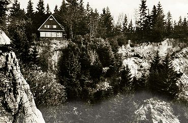
The Red Lake has an extension of around 110 m in an east-west direction and 70 m in a north-south direction. Its surface is about 520 m above sea level and is surrounded by up to 30 m high, vertically sloping rock walls made of volcanic basalt and tuff rocks. It was created by the gradual filling of a basalt quarry on the so-called "Hesselbühl", a basalt dome on a north-western spur of the Langenberg, where the basalt works Hesselbühl-Kaufungen from 1898 mined a large warehouse of magnificent columnar basalt . The basalt was transported on a narrow-gauge railway via Carmshausen to Witzenhausen and loaded there for road and rail construction.
The lake got its name because of the originally intense brick-red color of its water, which could be observed until around 1940 and was an attraction. It was caused by dissolved iron oxide particles from the red sandstone in the adjacent sandstone area, which adhered to clay particles in the penetrating groundwater and seepage water . For watercolor painters, the small lake with the red water, the black basalt walls and, in the summer, the frame by green forest offered a colorful motif. It is said that the lake probably lost its red color through a lightning strike, which could have led to the discharge of the colloids floating in the water and charged in the same direction . The former red coloring is only preserved on old, colored postcards .
hike
The two long-distance hiking trails Frau-Holle -pfad and Herkulesweg as well as the circular hiking trail Premiumweg P14 Bilstein , all three of which run together from the Bilstein tower and the small gastronomy attached to it (Bilsteinhütte) to the Red Lake, pass the southern shore of the lake and divide then there again. The Frau-Holle-path then leads in a generally south-easterly direction to Trubenhausen in the Gelster valley, the Herkulesweg north-east downhill to Hundelshausen an der Gelster, and the premium path P14 south towards Großalmerode .
From the terrace of the former “Forsthaus Roter See” ( 544 m ⊙ ) above the steep south face of the former quarry, you have an excellent view of the Werra valley. In the old forester's house there was once a forest restaurant, a popular excursion restaurant.
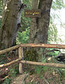
Viewing platform above the lake

View from the lake to the rock faces
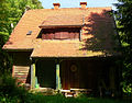
Hunting lodge and former forest restaurant above the lake


Individual evidence
- ↑ Map services of the Federal Agency for Nature Conservation ( information )
- ^ Hans-Jürgen Klink: Geographical land survey: The natural space units on sheet 112 Kassel. Federal Institute for Regional Studies, Bad Godesberg 1969. → Online map (PDF; 6.9 MB)
- ↑ Kaufunger Wald hiking map , on koenigsalm.de (PDF; 8.29 MB)
- ↑ EntdeckerTour Premiumweg P14 Bilstein , on naturparkfrauholle.land
- ^ "Forester's House Roter See, Werra-Meißner-Kreis". Historical local dictionary for Hessen. In: Landesgeschichtliches Informationssystem Hessen (LAGIS).
- ↑ Photo of the former forest restaurant (former forester's house) , on wiki-commons.genealogy.net
literature
- Jürgen Apel & Heidi Rüppel: Out into nature - tips for a Sunday excursion in the border triangle Hesse-Lower Saxony-Thuringia. LRSB-Verlag, Witzenhausen, 2005
- E. Blanck & R. Themlitz: The red lake near Wizenhausen; at the same time a further contribution to the recent and fossil weathering of the field-saving basalt. In: Chemie der Erde , II (3), 1938, pp. 375-407
- Herrmann Böhme: The riddle of the red lakes in Hessenland. In: Hessischer Gebirgsbote , 41 (4), Melsungen, 1935, pp. 29–31
- Karl Rudolf Fischer: The riddle of the Hessian "blood lakes". In: Volk und Scholle , 10 (2), Darmstadt, 1932, pp. 42–43
- Hermann Böhme: The riddle of the red lakes in Hessenland. In: Das Werratal , 4 (3), Eschwege, 1927, pp. 33–36
- Adolf Häger: A hike to the Red Lake near Witzenhausen. In: Heimat-Schollen , 192 (15), Melsungen, 1925, pp. 116-118
- E. Wedekind: On the knowledge of the colloid lake near Witzenhausen on the Werra. Kolloid-Zeitschrift, 70, Darmstadt, 1936, p. 39
- E. Wedekind: The Red Lake in the Kaufunger Forest near Witzenhausen. Treatises and reports by the Natural History Association in Kassel, 56, Kassel, 1925, pp. 163–169
- E. Wedekind & A. Straube: The colloid lake near Witzenhausen on the Werra. In: Journal for applied chemistry , 35 (43), Leipzig, 1922, p. 253