Compass direction
The compass direction describes the direction from a reference point (e.g. location) to another point on the earth's surface . The four main directions (also cardinal points ) are the basic directions north , east , south and west . Directions refer to the respective horizon and the location of the Earth's axis , the compass define the direction of the geographical coordinates of the meridians ( meridians ) extending in the points north and south poles meet and circles of latitude , the parallel to the Earth's rotation east-west run . In certain cultures, e.g. B. Indian or Buddhist, this concept is extended to six cardinal points through the inclusion of zenith (above / skyward) and nadir (below / earthward).
The four cardinal points

The four cardinal points are abbreviated with "N" (north), "O" or "E" (east, or English east), "S" (south) and "W" (west). They are used for orientation with the sun (see course of the sun ), the compass or the astronomical azimuth measurement as well as the indication of directions on the earth's surface, of courses or of wind directions . As basic directions, they also form the grid in maps .
- north
- Unless otherwise noted, north has always been at the top on western maps and sea maps for several centuries (some land surveys were oriented south until around 1920). This determination is based on the rotation of the earth ; the earth's axis points north at one end. North or more precisely true north (rwN) , map north or geographic north is the direction to the geographic North Pole . The alignment of a map, a plan or an aerial photo in the area according to the cardinal points is called northward .
- In the navigation further north directions are used, including magnetic compass north (MgN) or English. magnetic north (MN) and magnetic north ( mwN) , which are based on the magnetic field , as well as grid north ( GiN) or grid north (GN) as the reference direction of the coordinate systems used in geodesy ( Gauß-Krüger , UTM , UPS ).
- Historical names are Άρκτος , arktós , Arktus ('[Big] Bear', the constellation, of which Arctic , Arktos 'last light' was also one of the Roman Hours ), or Septentrio ('Seven Threshing Ox' referring to the seven stars of the Big Dipper ), the Roman name of the picture, and βορέας Boréas , the 'north wind', borealis 'north'
- south
- South is the opposite direction to north. In the northern hemisphere it is the direction of the highest position of the sun at noon. South was therefore previously called Meridies ' middle of the day ', and in mythology also Mesembria , the Hore of midday. Medieval Arabic world maps faced south.
- east
- East is the direction of rotation of the earth around its axis, perceived by us as the direction of sunrise (relatively accurate only to the equinoxes ). Latin oriens (compare Orient ), Greek Anatole or Anatolia , goddess of the sunrise (another Hore), Germanic Austri . Medieval Christian maps of the world (Mappae Mundi) were oriented to the east in the direction of Jerusalem and the location of Paradise .
- west
- West is the direction of sunset (only at the equinoxes). Latin occidens (compare Occident ), Greek Dysis , goddess of the sunset (also a Hore).
Other names
In astronomy , instead of north and south , one speaks of the meridian , since the daily highest level of stars can also occur north of the zenith (see upper culmination ). The vertical east-west line over the zenith, however, is referred to as the first vertical .
On medieval German representations, the cardinal points are also named after the position of the sun as follows:
- Beginning for east (latin oriens)
- Noon for the south
- Downfall for west (Latin occidens)
- Midnight for north
These terms are no longer used in German-speaking countries in the 20th and 21st centuries. The same applies to the previously used directions Levante (except for specifically the Middle East) and Ponente (west). In some Slavic languages , however, some of these original terms have been preserved in the literal translation.
Minor cardinal points and subdivision
The four cardinal points
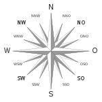
The intermediate directions northeast , southeast , southwest and northwest are used for more precise directions . Like the four cardinal points, they are at right angles to each other and bisect the angle. Together with them, they divide the compass or wind rose into eighths of 45 degrees each and have been used in this form in the tradition of angle measurement since ancient times .
In the Estonian and Finnish languages, the cardinal points have their own names.
- Northeast - Estonian kirre ; finnish koillinen
- Southeast - Estonian kagu ; finnish kaakko
- Southwest - Estonian noble ; Finnish lounas
- Northwest - Estonian loe ; finnish luode
The compass rose

For a more precise orientation, the cardinal points are even more finely divided into sea and aviation . The full circumference of the compass rose is divided into 360 ° clockwise and begins with north:
| 0 ° = N | → | 90 ° = O (or E ) | → | 180 ° = S. | → | 270 ° = W |
The wind rose , also compass rose ( English compass rose ), today mostly shows the 360 degree division. Traditionally, it is (now additionally) divided into 32 equally large angles of 11.25 degrees each, which are also known as nautical lines . East is abbreviated in the navigation with E (English East ) to avoid confusion with zero (“O” ↔ “0”) or with the French abbreviation for West (“Ouest”). More finely subdivided compass roses still have named markings at half lines.
In surveying, a full circle is divided into 400 gons , also called grads. In artillery, the division is made into 6400 artillery dash , written 6400¯, or in Switzerland into artillery promille A ‰. These details are still used for guidance.
Compass rose in heraldry
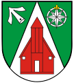
The compass rose is a common figure in heraldry . It does not occur often and is represented by superimposed stars . The north direction is rarely highlighted.
Compass rose in the upper coat of arms of the coat of arms of the Northwest Territories
Nordwestuckermark , compass rose with emphasis on the northwest direction
Schönefeld , representation of the north direction through a split lily
A compass rose in the Gallin coat of arms
System of naming
- Quarters have their own designation (N, O or E, S, W)
- Eighth notes are made up of the names of the quarters, with north and south before west and east (E or E): Northwest , Northeast , Southeast , Southwest - abbreviated NW, NE or NE, SO or SE, SW.
- Sixteenths are made up of the names of the quarters and the adjacent eighth note (in this order). Examples: WSW = west-southwest, SSW = south-southwest.
- Thirty-second parts are formed by adding the next quarter name in the corresponding direction to the respective adjacent quarter or eighth note with a “to”. Examples: WzS = West to South, SWzW = Southwest to West.
- half lines are formed from the name of the whole line (straight lines) and a "half" with the respective quarter name. For example: North and half east (N 1/2 E = 5.625 degrees) or Southeast and half east (SE 1/2 E) = 129.375 degrees).
- quarter lines are formed analogously from the name of the whole line (straight lines) and a “one quarter” or “three quarters” with the respective quarter name.
For a long time, however, the specification of degrees has been preferred.
Finer subdivision
In many specialist areas - including astronomy, geodesy, cartography and navigation - a finer subdivision of the cardinal points is necessary. Usually the degree (0 ° to 360 °) is used for this, with the north direction corresponding to the azimuth (or course) 0 °. Accordingly, east = 90 °, south 180 ° and west 270 °.
In the military and special measurements, so-called line divisions are also used (360 ° = 64-0-0 line, in English-speaking countries also 6400 mil). The latter has u. a. the advantage that the tangent of 1 mil is approximately 1/1000, meaning that such angles can easily be converted into distances if the distance is known.
China
(see section Earth branches # Cardinal points based on the earth branches )
Chinese navigators and astronomers preferred the twelve directions of the earth's branches instead of the four cardinal points. Contrary to the eight cardinal points of European character, these have a 30 ° division instead of a 45 °. For seafarers, however, these twelve cardinal points were not enough, which is why their number was doubled and thus a graduation in 15 ° intervals was achieved. New terms with different origins were introduced for the cardinal points between the earth circles. Experienced seafarers like Zhèng Hé even used a 48-section compass.
Determination of the south using the sun and an analog clock
A method previously taught by the Bundeswehr to determine the south direction using an analog clock with a twelve-hour scale is seriously flawed. According to this, if you align the hour hand to the sun, south is said to be on the bisector between the 12 o'clock mark and the hour hand, and in summer time on the bisector between the 1 o'clock mark and the hour hand. In fact, depending on the time of day and time of year, directional errors of the order of 45 ° occur in Germany.
Mnemonics
- N ie O hne S Eife W ash
- N maybe O hne S Tiefel W other
- N Eun O chsen S aufen W ater
- N ur O nkels S äubern W ände
- You look north and then write the word where? to know where west and east are. South is then in the "leftover" direction.
- In the east the sun rises - in the south it runs at noon - in the west it will set - in the north it can never be seen (only applies to the northern hemisphere between the tropic and the arctic circle ).
- For the Greek / Roman Horen there was the watch word ADAM: Anatole, Dysis, Arktus, Mesembria (O-W-N-S), the four quarters of the world '- this acronym plays with respect to Adam even in the early Christian cross symbolism involved ( Mission idea ), and is found as the inscription of the four bars.
Latin names
Especially in the Middle Ages and in the early modern period, the cardinal points were designated in neo-Latin language:
- OR = oriens, east
- ME = meridies, south
- OC = occidens, west
- SE = septentriones (septentrio or septemtriones), north
See also
- Chinese cardinal points: branches of the earth , eight trigrams , celestial trunks
- Greek and Roman cardinal points: Anemoi
- Location , time zone
Web links
Individual evidence
- ↑ Peter Schröder: Problems with orientation? Stars and Space, 5/2000, pp. 378–379.


