
Saint-Andelain
| Saint-Andelain | ||
|---|---|---|
|
||
| region | Bourgogne-Franche-Comté | |
| Department | Nièvre | |
| Arrondissement | Cosne-Cours-sur-Loire | |
| Canton | Pouilly-sur-Loire | |
| Community association | Communauté de communes Loire, Vignobles et Nohain | |
| Coordinates | 47 ° 19 ′ N , 2 ° 58 ′ E | |
| height | 164-271 m | |
| surface | 20.31 km 2 | |
| Residents | 519 (January 1, 2017) | |
| Population density | 26 inhabitants / km 2 | |
| Post Code | 58700 | |
| INSEE code | 58228 | |
| Website | http://www.saint-andelain.fr/ | |
.JPG) Town hall (Mairie) of Saint-Andelain |
||

Saint-Andelain is a commune with 519 inhabitants (as of January 1 2017) in the department of Nièvre in the region of Bourgogne Franche-Comté . It belongs to the Arrondissement of Cosne-Cours-sur-Loire and the Canton of Pouilly-sur-Loire .
Neighboring communities
Saint-Andelain is about 39 kilometers north-northwest of Nevers . Neighboring municipalities of Saint-Andelain are Saint-Martin-sur-Nohain in the north, Saint-Laurent-l'Abbaye in the northeast, Saint-Quentin-sur-Nohain in the east and northeast, Garchy in the southeast, Pouilly-sur-Loire in the south and West and Tracy-sur-Loire to the west and northwest.
Population development
| year | 1962 | 1968 | 1975 | 1982 | 1990 | 1999 | 2006 | 2011 | 2017 |
|---|---|---|---|---|---|---|---|---|---|
| Residents | 610 | 635 | 521 | 518 | 551 | 526 | 536 | 558 | 519 |
| Sources: Cassini and INSEE | |||||||||
Attractions
- Saint-Léger church from the 19th century
- former Protestant church
- Lookout tower (La Belvedère)
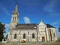
Saint-Léger church

Observation tower
.jpg)

Personalities
- Didier Dagueneau (1956-2008), winemaker
literature
- Le Patrimoine des Communes de la Nièvre. Volume 2, Flohic Editions, Charenton-le-Pont 1999, ISBN 2-84234-054-X , pp. 800-802.
Web links
Commons : Saint-Andelain - Collection of images, videos and audio files