
Saint-Père (Nièvre)
| Saint-Pere | ||
|---|---|---|
|
||
| region | Bourgogne-Franche-Comté | |
| Department | Nièvre | |
| Arrondissement | Cosne-Cours-sur-Loire | |
| Canton | Cosne-Cours-sur-Loire | |
| Community association | Loire, Vignobles et Nohain | |
| Coordinates | 47 ° 25 ′ N , 2 ° 58 ′ E | |
| height | 145-248 m | |
| surface | 17.09 km 2 | |
| Residents | 1,097 (January 1, 2017) | |
| Population density | 64 inhabitants / km 2 | |
| Post Code | 58200 | |
| INSEE code | 58261 | |
| Website | http://www.mairie-saintpere.fr/ | |

Saint-Pere is a French commune with 1,097 inhabitants (as of January 1 2017) in the department of Nièvre in the region of Bourgogne Franche-Comté . The municipality belongs to the Arrondissement of Cosne-Cours-sur-Loire and the canton of Cosne-Cours-sur-Loire (until 2015: Canton of Cosne-Cours-sur-Loire-Sud ).
location
Saint-Père is located about three kilometers east of the city center of Cosne-Cours-sur-Loire . Saint-Père is surrounded by the neighboring communities of Cours in the north, Saint-Loup in the northeast, Pougny in the east, Saint-Martin-sur-Nohain in the south and Cosne-Cours-sur-Loire in the west.
Population development
| year | 1962 | 1968 | 1975 | 1982 | 1990 | 1999 | 2006 | 2013 |
|---|---|---|---|---|---|---|---|---|
| Residents | 723 | 804 | 871 | 969 | 1,061 | 1,023 | 994 | 1,147 |
|
|
||||||||
Attractions
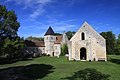
- Saint-Pierre-du-Trépas church, monument historique since 1907
- Commander of Villemoison, Monument historique since 1907/1987

Saint-Pierre-du-Trépas church
Commander of Villemoison


literature
- Le Patrimoine des Communes de la Nièvre. Volume 1, Flohic Editions, Charenton-le-Pont 1999, ISBN 2-84234-054-X , pp. 352-353.
Web links
Commons : Saint-Père - Collection of images, videos and audio files