
Tronsanges
| Tronsanges | ||
|---|---|---|
|
||
| region | Bourgogne-Franche-Comté | |
| Department | Nièvre | |
| Arrondissement | Cosne-Cours-sur-Loire | |
| Canton | La Charité-sur-Loire | |
| Community association | Communauté de communes Loire, Nièvre et Bertranges | |
| Coordinates | 47 ° 7 ' N , 3 ° 3' E | |
| height | 155-230 m | |
| surface | 8.58 km 2 | |
| Residents | 395 (January 1, 2017) | |
| Population density | 46 inhabitants / km 2 | |
| Post Code | 58400 | |
| INSEE code | 58298 | |

Tronsanges is a French municipality with 395 inhabitants (as of January 1 2017) in the department of Nièvre in the region of Bourgogne Franche-Comté . It belongs to the Arrondissement of Cosne-Cours-sur-Loire and the canton of La Charité-sur-Loire .
geography
Tronsanges is about 13 kilometers north-north-west of Nevers on the Loire . Neighboring municipalities of Tronsanges are La Marche in the north, Champvoux in the northeast, Chaulgnes in the east, Germigny-sur-Loire in the south, Beffes in the southwest and Saint-Léger-le-Petit in the west.
The A77 autoroute leads through the municipality .
Since 1861, the municipality has a stop at the railway Moret-Veneux-les-Sablons-Lyon-Perrache which trains of TER Bourgogne Franche-Comté the connection Cosne-sur-Loire - Nevers is operated.
Population development
| year | 1962 | 1968 | 1975 | 1982 | 1990 | 1999 | 2006 | 2011 | 2016 |
| Residents | 254 | 223 | 259 | 340 | 378 | 344 | 356 | 373 | 393 |
| Source: Cassini and INSEE | |||||||||
Attractions
- Saint-Blaise-et-Saint-Abdon church
- Monumental Pope Cross from 1867, Monument historique since 1971
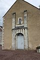
Saint-Blaise-et-Saint-Abdon church

Pope Cross


literature
- Le Patrimoine des Communes de la Nièvre. Volume 1, Flohic Editions, Charenton-le-Pont 1999, ISBN 2-84234-054-X , pp. 144-146.