Schwarzendamm
|
Schwarzendamm
City blocks
Coordinates: 52 ° 36 ′ 4 ″ N , 11 ° 2 ′ 24 ″ E
|
|
|---|---|
| Height : | 61 m above sea level NHN |
| Area : | 2.04 km² |
| Residents : | 53 (Dec. 31, 2018) |
| Population density : | 26 inhabitants / km² |
| Incorporation : | April 1, 1938 |
| Incorporated into: | Donitz |
| Postal code : | 38486 |
| Area code : | 039008 |
|
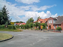
Crossroads in the center
|
|
Location of Schwarzendamm in Saxony-Anhalt |
Schwarzendamm is a district of the village of Dönitz and the town of Klötze in the Altmark district of Salzwedel in Saxony-Anhalt .
geography
The Altmark village of Schwarzendamm is located on the Drömling , around eight kilometers southwest of the city center of Klötze. The closest places are Altferchau (just under one kilometer west), Dönitz (one kilometer north), Kusey (four kilometers east) and Kunrau (four kilometers south). The Jeetze rises a few hundred meters southwest of the village on the southern ridge .
history
Schwarzendamm was laid out before 1789 as a Krugetablissement (inn) on the desert field Prilop. At the beginning of the 18th century it was settled by colonists . Colonist houses were mentioned next to the jug as early as 1833. In 1840 the place was then a colonist village with a jug, six basic seats, two granny annals and eight houses.
Prilop
The village was called Prilop in the Middle Ages and was described as desolate in a document in 1420 : dacz wuste dorff prylopp . Also in 1435 it is called dat wuste dorp Prylop . Further mentions are 1492 prylop and 1598 the desert village Prilop , 1804 Prielop .
Wilhelm Zahn describes the location of Prilop in 1909 as follows: “On the right bank of the Jeetze, at the southern end of the Moores, 1.25 kilometers south of Dünitz, 1 kilometer east of Alt-Ferchau, lies the desert. The place of the old settlement is still called the village today . Immediately to the west of it is the current Schwarzendamm colony. "
Incorporations
On April 1, 1938, the communities Schwarzendamm, Dönitz and Altferchau in the district of Salzwedel merged to form a new community called Dönitz .
With the incorporation of Dönitz into Klötze on January 1, 2010, the district of Schwarzendamm became part of the town of Klötze and the newly established village of Dönitz.
Population development
|
|
|
religion
The Protestant Christians from Schwarzendamm are churched in the Neuferchau parish, which belonged to the parish of Immekath. Schwarzendamm today belongs to the parish of Steimke-Kusey in the parish of Salzwedel in the Provostspengel Stendal-Magdeburg of the Evangelical Church in Central Germany .
Culture and sights
- The local cemetery is in the south of the village.
- In Schwarzendamm there is a memorial for the fallen of the First and Second World Wars, a field stone pyramid crowned by an eagle.
traffic
Schwarzendamm is connected to Dönitz and Kunrau as well as Altferchau and Kusey by district roads. Buses run to Beetzendorf , Klötze and Kunrau, some of which are on- call buses .
literature
- Wilhelm Zahn : Local history of the Altmark . Edited by Martin Ehlies based on the bequests of the author. 2nd Edition. Verlag Salzwedeler Wochenblatt, Graphische Anstalt, GmbH, Salzwedel 1928, DNB 578458357 , p. 146-147 .
- JAF Hermes, MJ Weigelt: Historical-geographical-statistical-topographical handbook from the administrative districts of Magdeburg . Topographical part. Ed .: Verlag Heinrichshofen. tape 2 , 1842, p. 346 , 147.Blackendamm ( digitized version ).
Individual evidence
- ^ A b Peter P. Rohrlach: Historical Ortlexikon für die Altmark (Historical Ortlexikon für Brandenburg, Part XII) . In: Publications of the Brandenburg State Main Archives . Berliner Wissenschafts-Verlag, 2018, ISBN 978-3-8305-2235-5 , pp. 2020-2021 .
- ^ City of Klötze, residents' registration office: population on December 31, 2018 . January 9, 2019.
- ↑ Saxony-Anhalt viewer of the State Office for Surveying and Geoinformation ( notes )
- ^ Adolph Friedrich Riedel : Codex diplomaticus Brandenburgensis : Collection of documents, chronicles and other source documents . Main part 1st volume 17 . Berlin 1859, p. 274 ( digitized version ).
- ^ Adolph Friedrich Riedel : Codex diplomaticus Brandenburgensis : Collection of documents, chronicles and other source documents . Main part 1st volume 17 . Berlin 1859, p. 275 ( digitized version ).
- ^ Friedrich Wilhelm August Bratring : Statistical-topographical description of the entire Mark Brandenburg . For statisticians, businessmen, especially for camera operators. Berlin 1804, p. 383 ( digitized version ).
- ^ Wilhelm Zahn : The desolation of the Altmark . In: Historical sources of the Province of Saxony and neighboring areas . tape 43 . Hendel, Halle as 1909, p. 183 .
- ↑ Administrative region of Magdeburg (Ed.): Official Gazette of the Government of Magdeburg . 1938, ZDB -ID 3766-7 , p. 127 .
- ↑ Parish Almanac or the Protestant clergy and churches of the Province of Saxony in the counties of Wernigerode, Rossla and Stolberg . 19th year, 1903, ZDB -ID 551010-7 , p. 51 ( wiki-de.genealogy.net [accessed January 1, 2019]).
- ↑ Steimke-Kusey parish area. Retrieved January 1, 2019 .
- ↑ Online project monuments to the likes. Schwarzendamm at www.denkmalprojekt.org. April 1, 2018, accessed January 1, 2019 .

