Germenau
|
Germenau
City blocks
Coordinates: 52 ° 33 ′ 42 ″ N , 10 ° 59 ′ 5 ″ E
|
|
|---|---|
| Height : | 64 m |
| Area : | 80.4 ha |
| Incorporation : | April 1, 1937 |
| Incorporated into: | Jahrstedt |
| Postal code : | 38486 |
| Area code : | 039008 |
|
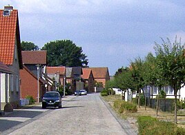
Germenau, through-town, 2006
|
|
Location in Saxony-Anhalt |
Germenau is a residential area in the Jahrstedt district of the town of Klötze in the Altmark district of Salzwedel in Saxony-Anhalt .
geography
The Altmark street village Germenau located east of the ear on the northern edge of the wetland nature park Drömling .
In 2018 the weir built in 1956 on the Ohre near Jahrstedt and Germenau was washed over and under by water and collapsed. The reconstruction of a fish pass at the Ohre weir in Jahrstedt / Germenau is planned for 2019.
history
The first mention comes from a feudal letter from 1472 as dat halue wüsten dorp Germen . Elector Albrecht von Brandenburg entrusted Werner and Gebhard von Alvensleben with the castle and bailiwick of Gardelegen. The village was no longer populated at that time, but a desert .
In 1506, some places were reported as these ... relocated and pledged goods and villages , including Germen , in a document about the pledging of half of Gardelegen Castle. From this, Wilhelm Zahn concluded that the village must have been rebuilt in 1506. In 1711 the place was called Garmenow . In 1745 it was a noble estate and sheep farm, in 1775 it was a farm and sheep farm with 6 Graubünden residents and residents . In 1789 the colonist village was inhabited by foreigners . In 1804 Bratring reported on the colony village and Vorwerk Germenau, built on the desert field of Germen.
In 1986 the agricultural production cooperative "Karl Marx" operated the Germenau pullet facility.
Incorporations
On April 1, 1937, the communities Germenau and Jahrstedt from the district of Salzwedel were merged to form a community called Jahrstedt. This made Germenau one of Jahrstedt's residential areas. With the incorporation of Jahrstedt to Klötze on January 1, 2010, Germenau remained with Jahrstedt.
Population development
|
|
|
Source:
religion
The Protestant Christians from Germenau and Jahrstedt are churched in the parish of Steimke and today belong to the parish of Steimke-Kusey in the parish of Salzwedel in the provost district of Stendal-Magdeburg of the Evangelical Church in Central Germany .
Culture and sights
- The local cemetery is in the north of the village.
- In Germenau there is a memorial for those who died in the First and Second World Wars.
literature
- Wilhelm Zahn : Local history of the Altmark. Edited by Martin Ehlies based on the bequests of the author. 2nd Edition. Verlag Salzwedeler Wochenblatt, Graphische Anstalt, Salzwedel 1928, DNB 578458357 , OCLC 614308966 , p. 134 .
- JAF Hermes, MJ Weigelt: Historical-geographical-statistical-topographical handbook from the administrative districts of Magdeburg . Topographical part. Ed .: Verlag Heinrichshofen. tape 2 , 1842, p. 332 ( digitized version ).
Individual evidence
- ↑ a b c d Peter P. Rohrlach: Historical local lexicon for the Altmark (Historical local lexicon for Brandenburg, Part XII) . Berliner Wissenschafts-Verlag, Berlin 2018, ISBN 978-3-8305-2235-5 , pp. 756-757 .
- ↑ Saxony-Anhalt viewer of the State Office for Surveying and Geoinformation ( notes )
- ↑ Matthias Mittank: No quick solution in sight . Broken Jahrstedter traffic jam: decision to rebuild postponed by four weeks. In: Altmark newspaper . April 28, 2018 ( az-online.de ).
- ^ Adolph Friedrich Riedel : Codex diplomaticus Brandenburgensis : Collection of documents, chronicles and other source documents . Main part 1st volume 6 . Berlin 1846, p. 141-142 ( digitized version ).
- ^ Adolph Friedrich Riedel : Codex diplomaticus Brandenburgensis : Collection of documents, chronicles and other source documents . Main part 1st volume 6 . Berlin 1846, p. 159 ( digitized version - CCXXII).
- ^ Wilhelm Zahn : Heimatkunde der Altmark. Edited by Martin Ehlies based on the bequests of the author. 2nd Edition. Verlag Salzwedeler Wochenblatt, Graphische Anstalt, Salzwedel 1928, DNB 578458357 , OCLC 614308966 , p. 134 .
- ^ Friedrich Wilhelm August Bratring : Statistical-topographical description of the entire Mark Brandenburg . For statisticians, businessmen, especially for camera operators. Ed .: Berlin. tape 1 , 1804, p. 373 ( digitized version ).
- ↑ Administrative region of Magdeburg (Ed.): Official Gazette of the Government of Magdeburg . 1937, ZDB -ID 3766-7 , p. 187 .
- ↑ District directory of the state of Saxony-Anhalt (directory of the municipalities and parts of the municipality), territorial status January 2014, State Statistical Office Saxony-Anhalt, Halle (Saale), 2016
- ↑ Parish Almanac or the Protestant clergy and churches of the Province of Saxony in the counties of Wernigerode, Rossla and Stolberg . 19th year, 1903, ZDB -ID 551010-7 , p. 52 ( wiki-de.genealogy.net [accessed March 2, 2019]).
- ↑ Online project monuments to the likes. Germenau at www.denkmalprojekt.org. April 1, 2018, accessed March 2, 2019 .

