
Sirolo
| Sirolo | ||
|---|---|---|

|
|
|
| Country | Italy | |
| region | Brands | |
| province | Ancona (AN) | |
| Coordinates | 43 ° 32 ' N , 13 ° 37' E | |
| height | 125 m slm | |
| surface | 16.68 km² | |
| Residents | 4,101 (Dec. 31, 2019) | |
| Population density | 246 inhabitants / km² | |
| Post Code | 60020 | |
| prefix | 071 | |
| ISTAT number | 042048 | |
| Popular name | Sirolesi | |
| Patron saint | Nicholas of Myra | |
| Website | Sirolo | |
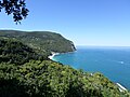
 View of Sirolo |
||

Sirolo (in the local dialect: Sciròlo ) is an Italian municipality ( comune ) with 4101 inhabitants (as of December 31, 2019) in the province of Ancona in Marche . The municipality is located about 13.5 kilometers southeast of Ancona on the Adriatic coast . The Aspio delimits the municipality in the southwest.
geography
Sirolo is 125 m above sea level , south of Monte Conero . Most of the urban area is part of the "Parco Regional del Conero" founded in 1987, one of the most important places in Italy for bird watching . This is rich in typical Mediterranean flora ( strawberry trees , holm oaks, pines, gorse, yew trees etc.) and fauna (deer, stone marten, weasel, pheasants, partridges, jays, wild boars, wolves, foxes, hares, squirrels). It is the only place on the Adriatic coast where peregrine falcons, blue alder and strawberry tree butterflies nest.
Every year since 1994, Sirolo has received the Blue Flag from the FEE; thanks to the quality of its sea water and the environmentally friendly performance of its area, it is one of the few cities that has been awarded the ISO 14001 eco-label. In 2016 Sirolo received the Green Flag for the adaptability of the beaches to children and under 18, by a jury of psychologists.
beaches
Sirolo has 8 beaches:
- Spiaggia Urbani is just below the village of Sirolo. It is about 300 meters from the center. It consists of pebbles and large stones.
- Spiaggia di San Michele is long and stretches from Spiaggia Ubani to below Monte Conero . It is about 500 meters from the center of Sirolo.
- Sassi Neri is not a real beach, more of a stretch of coast. This terrain consists of many boulders, crevices and stones. It is about 600 meters from the center of Sirolo.
- Spiaggia delle Velare is also called Spiaggia delle Due Sorelle because its two cliffs are called "due Sorelle" ("two sisters") because they look like two praying nuns. The beach consists of small pebbles and sand. This is the most famous beach on the Conero coast. In 2013 the beach was named one of the 10 most beautiful beaches in Italy.
- Spiaggia dei Lavori is made up of pebbles and larger stones that have been smoothed by the sea and the wind.
- Spiaggia dei Forni and Spiaggia dei Gabbiani are two small beaches.
- Spiaggia dei Frati can be visited freely as well as in a lido.

Spiaggia Urbani

View to Monte Conero
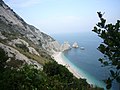
Spiaggia delle Due Sorelle
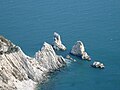
The two sisters

Spiaggia dei Gabbiani


.jpg)


history
In a quarry between Sirolo and Ancona, the transition between the Oligocene and the Eocene can be traced. The name of the community is derived from a knight of Belisarius . Originally it was the settlement area of the Picener .
traffic
The A14 autostrada from Bologna towards Taranto and Aspio form the south-western border of the municipality.
Web links
Individual evidence
- ↑ Statistiche demografiche ISTAT. Monthly population statistics of the Istituto Nazionale di Statistica , as of December 31 of 2019.
- ↑ Bandiera Blu program. Retrieved May 31, 2017 .
- ↑ Estate 2013: ecco le spiagge più belle d'Italia vote on the web. In testa Cala Bianca di Camerota (SA) | Legambiente . ( legambiente.it [accessed May 31, 2017]).

Agugliano | Ancona | Arcevia | Barbara | Belvedere Ostrense | Camerano | Camerata Picena | Castelbellino | Castelfidardo | Castelleone di Suasa | Castelplanio | Cerreto d'Esi | Chiaravalle | Corinaldo | Cupramontana | Fabriano | Falconara Marittima | Filottrano | Genga | Jesi | Loreto | Maiolati Spontini | Mergo | Monsano | Monte Roberto | Monte San Vito | Montecarotto | Montemarciano | Morro d'Alba | Numana | Offagna | Osimo | Ostra | Ostra Vetere | Poggio San Marcello | Polverigi | Rosora | San Marcello | San Paolo di Jesi | Santa Maria Nuova | Sassoferrato | Senigallia | Serra San Quirico | Serra de 'Conti | Sirolo | Staffolo | Trecastelli