
Solar eclipse of May 20, 2012
| Solar eclipse of May 20, 2012 | |
|---|---|
 Animation of the annular solar eclipse on May 20, 2012 |
|
| classification | |
| Type | Ring-shaped |
| area |
Asia , Pacific , North America Annular: China , Japan , Pacific , western USA |
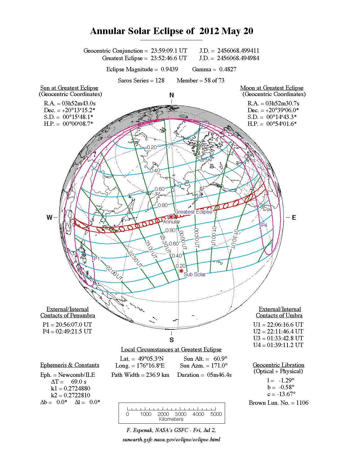
| Saros cycle | 128 (58 of 73) |
| Gamma value | 0.4827 |
| Greatest eclipse | |
| Duration | 5 minutes 46 seconds |
| place | Pacific |
| location | 46 ° 5 ' N , 176 ° 17' E |
| time | May 20, 2012 11:52:47 PM UT |
| size | 0.9439 |
The annular solar eclipse of May 20, 2012 began in East Asia , played out primarily over the North Pacific , and ended in western North America. Since numerous East Asian metropolises were in the visibility area, including Hong Kong and Tokyo and with Guangdong also the most populous province in China , this eclipse could have become one of the most people observed. The darkness was not observable from Central Europe. It is the 58th of the 72 solar eclipses Saros cycle with the number 128. The ring-shaped phase lasted a maximum of 5 minutes and 46 seconds.
course
For the first time, the sun was eclipsed in a ring shape during the sunrise near the Chinese city of Beihai in the north of the Gulf of Tonkin . According to local time, May 21 was already there. The corridor then moved with ring-shaped visibility in an east-northeast direction over the coast of the South China Sea and passed over numerous Chinese metropolises, for example Zhanjiang , Maoming , Jiangmen , Guangzhou , Shenzhen , Hong Kong , Shantou , Xiamen and Fuzhou . In northern Taiwan , too , including the capital Taipei , the moon moved centrally in front of the sun, before the zone of annular visibility continued across the East China Sea towards Japan. In Japan, the shadow path first covered the east of the island of Kyūshū and Shikoku , before reaching the largest metropolises in Japan in the southeastern part of the Japanese main island of Honshū : Kobe , Osaka , Kyōto , Nagoya , Shizuoka , Yokohama and Tokyo . In Tokyo, the solar eclipse occurred at 7:34 am local time and the annular phase lasted a little over 5 minutes. In Fukushima Prefecture , the zone of circular visibility left the main Japanese islands.
The eclipse continued over the North Pacific until the maximum of the eclipse occurred 400 kilometers southwest of the Aleutian island of Amchitka . The sun was there about 61 ° above the horizon. The width of the zone with ring-shaped visibility was 237 kilometers there, which is significantly smaller than at the beginning or at the end of the eclipse, where the width was over 300 kilometers.
A little later the eclipse corridor crossed the date line , so that the following eclipse sequence took place one day earlier than the previous one, i.e. on May 20th, according to local time. At 17:34 local time zone reached annular visibility in Port Orford in the US state of Oregon the Americas. The eclipse could be seen in a ring except for Oregon in the US states of California , Nevada , Utah , Arizona , Colorado and New Mexico . The cities of Redding , Reno , St. George , Albuquerque and Santa Fe were in the zone of ring-shaped visibility, and the eclipse could also be observed in the Grand Canyon shortly before sunset.
The partial phase could be seen from East Asia, the Arctic Ocean, Greenland , Alaska , Canada , United States, and Mexico .

Kofu , Japan

Minneapolis , Minnesota

Near Phoenix , Arizona

East of Ogden , Iowa


literature
- Wolfgang Held: Solar and lunar eclipses and the most important astronomical constellations up to 2017. Verlag Freies Geistesleben, Stuttgart 2005, ISBN 3-7725-2231-9 .
Web links
- solar-eclipse.de: The annular solar eclipse from May 20th, 2012
- Eclipse path of the solar eclipse of May 20, 2012 at NASA
- NASA: Annular Solar Eclipse of 2012 May 20
- NASA: Solar Eclipses of Saros 128
Individual evidence
- ↑ Hans Ulrich Keller: Kosmos Himmelsjahr 2012: Sun, moon and stars in the course of the year . P. 12 f., Franckh-Kostmos, Stuttgart 2011, ISBN 978-3-440-12608-0
|
Previous solar eclipses:
|
Later solar eclipses:
|
|||||||||
|
July 11, 2010 (total) |
January 4, 2011 (partial) |
June 1, 2011 (partial) |
July 1, 2011 (partial) |
November 25, 2011 (partial) |
May 20, 2012 (circular) |
November 13, 2012 (total) |
May 10, 2013 (circular) |
November 3, 2013 (hybrid) |
April 29, 2014 (circular) |
October 23, 2014 (partial) |
|
|
|
|
|
|
|
|
|
|
|
|
| Lists: 20th century • 21st century • All lists | ||||||||||