
Tây Bắc Bộ
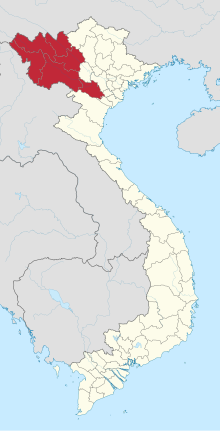
Tây Bắc Bộ ( Vietnamese for northwest ) is a region in Vietnam that shares a common border with Laos and China . The region is also known as the North-Northwest of Vietnam and is a geographical part of northern Vietnam ( Bắc Bộ ), which also includes the Northeast Region ( Đông Bắc Bộ ) and the Red River Delta ( Đồng Bằng Sông Hồng ).
Provinces
| Provinces / municipalities | Capital | Population ( census of April 1, 2009) | Area (km²) |
|---|---|---|---|
| Điện Biên | Dien Bien Phu | 459.100 | 9,562.5 km² |
| Hòa Bình | Hòa Bình | 820,400 | 4,684.2 km² |
| Lai Chau | Lai Chau | 319,900 | 9,112.3 km² |
| Sơn La | Sơn La | 1,007,500 | 14,174.4 km² |
| Lào Cai | Lào Cai | 613.075 | 6,357 km² |
| Yên Bái | Yên Bái | 740.905 | 6,882.9 km² |
geography
Georeference

The geo-referencing of the Northwest has not yet agreed. Experts suggested that the region should be located south of the right bank of the Red River . Others, in turn, limit the region south of the Hoàng Liên S -Gn Mountains. The geologist Lê Bá Thảo suggested that the region is bounded by the Hoàng Liên Sơn Mountains in the east and by the Mã Mountains in the west .
topography
The region is characterized by high mountain ranges that extend from the northwest to the southeast. The Hoàng Liên Sơn Mountains are up to 180 km long and 30 km wide. It also has several peaks that can be from 2800 to 3000 m high. The Mã Mountains are 500 km long and 1800 m high. The Black River flows between these two mountain ranges . The Black flow is the largest flow of this region, in addition to other smaller rivers including Ma and flows along a plateau of limestone, which extends from PhongTho about Thanh Hóa until after Tà Phình , Mộc Chau and Nà San extends. There are also several basins in this region in Điện Biên , Nghĩa Lộ and Mường Thanh .
geology
The geological processes began 500 million years ago and continue to this day. The region was previously covered by the sea and some mountain peaks of the Hoàng Liên Sơn Mountains and Mã Mountains protruded from the sea. First there was a regression of the coastline , then a transgression lasting hundreds of years . As a result of this process, sedimentary rocks such as mica schist and limestone were deposited . In the late Paleozoic , more precisely in the Gzhelian (the highest chronostratigraphic stage of the Pennsylvania ) the Hoàng Liên Sơn Mountains and the Mã Mountains were completely raised. 150 million years ago during the Alpidic orogeny two geosynclines were superimposed , so that the sediments folded and thrusts formed , leading to the formation of an orogen . More precisely, one speaks here of a eugeosyncline with strong initial magmatism in the core area of the orthogeosyncline, which is used to raise the north-western region at a height of up to 1000 m above sea level. NN led. At the same time as the folding, limestone was poured out and the age of today's karst plateau Đồng Văn could be found out.
Earthquake risk
As a geodynamically active region with geosynclines, the northwest region is the region with the highest earthquake risk in Vietnam.
climate

The Hoàng Liên Sơn Mountains act as a weather divide in the northwest region . During the winter monsoon season , the northeast monsoon wind cannot pass the mountains. Therefore, the north has a winter-dry subtropical climate in which there is a cool and dry season from November to April. On its way from the ocean to the continent, the monsoon wind absorbs moisture over the water surface and rains it down to a large extent on the windward side (east side) of the mountains. A foehn wind develops on the lee side (west side) .
Individual evidence
- ↑ Lê Bá Thảo (Ed.): Thiên nhiên Việt Nam . Nhà xuất bản Giáo dục, 2009, p. 76 (Vietnamese).
- ↑ Maingan92 (Ed.): Nghiên cứu xâm nhập mặn nước dưới đất trầm tích Đệ tứ vùng Nam Định: Giáo Trình . Cẩm Thương, S. 47 (Vietnamese).
- ↑ a b GIỚI THIỆU VÙNG TÂY BẮC. (No longer available online.) In: Asia Spirit Travel. http://sapahagiangtour.com/ , archived from the original on November 5, 2016 ; Retrieved November 5, 2016 (Vietnamese). Info: The archive link was inserted automatically and has not yet been checked. Please check the original and archive link according to the instructions and then remove this notice.
- ^ Vùng Tây Bắc. (No longer available online.) In: Học Và Làm. Archived from the original on November 9, 2016 ; Retrieved November 9, 2016 (Vietnamese). Info: The archive link was inserted automatically and has not yet been checked. Please check the original and archive link according to the instructions and then remove this notice.
Regions: Northwest | Northeast | Red River Delta | Northern coastal region | Southern coastal region | Central highlands | Southeast | Mekong Delta
Large cities at the provincial level: Cần Thơ | Đà Nẵng | Hải Phòng | Hà Nội | Thành phố Hồ Chí Minh
Provinces: An Giang | Bắc Giang | Bắc Kạn | Bạc Liêu | Bắc Ninh | Bà Rịa-Vũng Tàu | Bến Tre | Bình Định | Bình Dương | Bình Phước | Bình Thuận | Cà Mau | Cao Bằng | Đắk Lắk | Đắk Nông | Điện Biên | Đồng Nai | Đồng Tháp | Gia Lai | Hà Giang | Hải Dương | Hà Nam | Hà Tĩnh | Hòa Bình | Hậu Giang | Hưng Yên | Khánh Hòa | Kiên Giang | Kon Tum | Lai Châu | Lâm Đồng | Lạng Sơn | Lào Cai | Long On | Nam Định | Nghệ An | Ninh Bình | Ninh Thuận | Phu Thọ | Phú Yên | Quảng Bình | Quảng Nam | Quảng Ngãi | Quảng Ninh | Quảng Trị | Sóc Trăng | Sơn La | Tây Ninh | Thái Bình | Thái Nguyên | Thanh Hóa | Thừa Thiên-Huế | Tiền Giang | Trà Vinh | Tuyên Quang | Vĩnh Long | Vĩnh Phúc | Yên Bái
Coordinates: 21 ° 20 ' N , 104 ° 18' E