
Grotenburg
| Grotenburg | ||
|---|---|---|
 Left the Grotenburg with the Hermannsdenkmal and right the Bielstein |
||
| height | 386 m above sea level NN | |
| location | Germany , North Rhine-Westphalia | |
| Mountains | Teutoburg Forest | |
| Coordinates | 51 ° 54 '42 " N , 8 ° 50' 22" E | |
|
||

-Pano.jpg)

The Grotenburg is a 386 m high mountain in the southeast of the Teutoburg Forest , in Detmold - Hiddesen , Lippe district , North Rhine-Westphalia ( Germany ). The Grotenburg is particularly known for the Hermannsdenkmal .
The mountain is sometimes also called Teutberg or Teut for short . However, it is controversial whether this designation is historically correct. According to Moritz Friedrich Essellen , the name goes back to Christian Gottlieb Clostermeier .
geography
The heavily forested mountain is located in the Lippe Forest, a southeastern part of the Teutoburg Forest, around 1.5 km (as the crow flies ) south of the Detmold district of Hiddesen. A special feature is that the mountain is located north of the main ridge of the Teutoburg Forest and is therefore quite striking thanks to its height.
On the slopes of the Grotenburg - especially on the eastern slope - there are many springs that feed some small streams. While only the 6.7 km long Heidenbach and the Silberbach, which flows into the Berlebecke , arise on the southern slope , there are several springs on the eastern slope. This is where the Rautenbergbach rises, a 2.1 km long left tributary of the Berlebecke. Its tributaries also arise here: the 0.6 km long Schmandbach, the 0.9 km long grass frog brook, the 0.4 km long toad brook and the 0.5 km long Teichmolchbach.
Circular ramparts
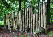
On the summit of the mountain there are remains of a ring wall system , located directly below today's parking lot and can be visited. These ramparts were part of a hill fort from the late pre-Roman Iron Age. This is known as the Großer Hünenring . The term Grotenburg itself means large castle and refers directly to the ramparts.
The small Hünenring , a medieval rampart, is located on the driveway to the memorial area of the mountain summit .

Wall remains of the Großer Hünenring (below the parking lot)
Reconstructed wall of the Großer Hünenring

Wall Kleiner Hünenring (on the left the inner area of the ramparts)


Hermannsdenkmal
1838–1875, the Hermannsdenkmal was erected within the larger of the two ring walls . Stones from the wall were also used for its construction, which was severely damaged as a result and is only partially preserved today.
traffic
To get to the Hermannsdenkmal , the Grotenburg can be accessed by car from two sides . You can reach the Grotenburg via a well-developed road from the Detmold district of Hiddesen and you can also go back down in this direction, but you can also go down to Heiligenkirchen . However, the road to Heiligenkirchen is a one-way street , which can only be used as far as the parking lot from the direction of Heiligenkirchen.
This road is the steepest in the Lippe district and is probably also one of the steepest in Germany. The short section with the greatest gradient of 20% is on the descent to Heiligenkirchen. This route over the Grotenburg is also popular with cyclists .
The monument can be reached from several sides on the footpath, for example via the Hermannsweg from Hiddesen or the Denkmalweg from Heiligenkirchen.
Attractions
The following sights and geographical destinations are located near the Teutberg:
Individual evidence
- ^ MF Essellen: The Roman fort Aliso, the Teutoburg Forest and the Pontes longi; a contribution to the history of the wars between the Romans and Germans in the period from the year 12 before to the spring of 16 AD . Rümpler, Hanover 1857, p. 118 .
- ^ MF Essellen: The Roman fort Aliso, the Teutoburg Forest and the Pontes longi: a ... p. 118 , accessed on November 2, 2014 .
- ↑ Entry on Kleiner Hünenring in the scientific database " EBIDAT " of the European Castle Institute
literature
- Friedrich Hohenschwert : "Prehistoric and early historical fortifications in Lippe". Lippe Studies, Vol. 4, Landesverband Lippe (Ed.). Münster 1978. ISBN 3-921428-21-1
