Tongliao
| Tōngliáo Shì 通辽 市 Tongliao |
|
|---|---|
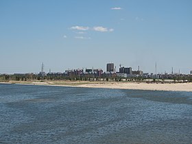
 Horqin Ward from Shengli Road Bridge |
|
| Coordinates | 43 ° 37 ' N , 122 ° 16' E |
 Location of Tongliao in Inner Mongolia |
|
| Basic data | |
| Country | People's Republic of China |
| region | North china |
| Autonomous area | Inner Mongolia |
| ISO 3166-2 | CN-NM |
| status | District-free city |
| structure | 1 city district, 1 independent city, 1 district, 5 banners |
| height | 179 m |
| surface | 168 km² |
| Metropolitan area | 59,535 km² |
| Residents | 940,000 (2018) |
| Metropolitan area | 3,139,153 (2010) |
| density | 5,595.2 Ew. / km² |
| Metropolitan area | 52.7 Ew. / km² |
| Post Code | 028000 |
| Telephone code | (+86) 475 |
| Time zone | China Standard Time (CST) UTC +8 |
| License Plate | 蒙 G |
| Website | www.tongliao.gov.cn |
Tongliao ( Chinese 通辽 市 , Pinyin Tōngliáo Shì ;ᠲᠦᠩᠯᠢᠶᠣᠤ ᠬᠣᠲᠠ Tüŋliyou qota ) is a district-free city in the east of the Inner Mongolia Autonomous Regionin the northeast of the People's Republic of China . It is located at 43 ° north latitude and 122 ° east longitude and emerged from the Jirem Bund (哲里木 盟 Zhelimu Meng ). The former county town of Tongliao was converted into the Horqin District. The administrative area of the city of Tongliao has an area of 59,535 km² and around 3.12 million inhabitants (2016). 540,338 people live in the actual urban settlement area of Tongliao (2010 census).
Administrative structure
The city of Tongliao is made up of a district, a city, a district and five banners. These are:
- Horqin district (科尔沁 区), 3,212 km², 810,000 inhabitants (2004);
- City of Holin Gol (霍林郭 勒 市), 585 km², 70,000 inhabitants (2004);
- District of Kailu (开 鲁 县), 4,488 km², 390,000 inhabitants (2004), capital: Greater Kailu municipality (开 鲁 镇);
- Hure-Banner (库伦旗), 4,650 km², 180,000 inhabitants (2004), main town: Hure municipality (库伦 镇);
- Naiman-Banner (奈曼旗), 8,120 km², 430,000 inhabitants (2004), capital: Daqin Tal municipality (大 沁 他 拉 镇);
- Jarud-Banner (扎鲁特旗), 17,193 km², 300,000 inhabitants (2004), main town: Lubei municipality (鲁北 镇);
- Middle Horqin banner of the left wing (科尔沁 左翼 中 旗), 9,811 km², 530,000 inhabitants (2004), capital: Baokang Municipality (保康 镇);
- Rear Horqin banner of the left wing (科尔沁 左翼 后 旗), 11,476 km², 400,000 inhabitants (2000), capital: Ganjag Municipality (甘 旗 卡 镇).
Ethnic breakdown of the population of Tongliao (2000)
The 2000 census counted 3,028,419 inhabitants (population density 50.87 inh. / Km²).
| Name of the people | Residents | proportion of |
|---|---|---|
| Han | 1,548,721 | 51.14% |
| Mongols | 1,373,470 | 45.35% |
| Manchu | 88,654 | 2.93% |
| Hui | 12,447 | 0.41% |
| Korean | 2,709 | 0.09% |
| Xibe | 781 | 0.03% |
| Daur | 492 | 0.02% |
| Others | 1,145 | 0.03% |
sons and daughters of the town
- Wuyuntana (singer)
- Jiang Luxia (National Wushu Master, Martial Artist and Actress)
literature
- Jinri Nei Menggu: Zhelimu 今日内蒙古: 哲里木 盟 (Inner Mongolia today: Jirem). 内蒙古 人民出版社Nei Menggu renmin chubanshe (Inner Mongolia People's Publishing House ). 呼和浩特 Hohhot 1997. ISBN 7-204-03545-3 . 9 + 129 pages.
Web links
Individual evidence
- ↑ Postcode ZIP code Tongliao, China - GeoPostcodes. Retrieved July 31, 2018 .