Bayan only
|
巴彦淖尔 市 Bayan Nur Bayan Nur |
||
|---|---|---|
|
|
||
| Coordinates | 40 ° 45 ' N , 107 ° 23' E | |
 Location of Bayan Only in Inner Mongolia Location of Bayan Only in Inner Mongolia
|
||
| Basic data | ||
| Country | People's Republic of China | |
| Inner Mongolia | ||
| ISO 3166-2 | CN-NM | |
| surface | 65,788 km² | |
| Residents | 1,760,000 (2010) | |
| density | 26.8 Ew. / km² | |
|
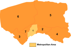
Division of the Bayan Nur administrative area
|
||
| Mongolian name | |
|---|---|
| Mongolian script : | ᠪᠠᠶᠠᠠᠨᠠᠭᠤᠷ ᠬᠣᠲ |
| Transliteration: | bayan naɣur qota |
| Cyrillic script : | Баяннуур хот |
| ISO transliteration : | Baânnuur hot |
| Transcription: | Bajannuur chot |
| Chinese name | |
| Traditional : | 巴彥淖爾 市 |
| Simplified : | 巴彦淖尔 市 |
| Pinyin : | Bāyànnào'ěr Shì |
| Wade-Giles : | Pa-yen-nao-êrh Shih |
Bayan Nur ( Chinese 巴彥淖爾 市 / 巴彦淖尔 市 , Pinyin Bāyànnào'ěr Shì ) is a district-free city in the west of the Inner Mongolia Autonomous Region in the north of the People's Republic of China . Bayan Nur got its Mongolian name, which means rich lake , because of the numerous freshwater lakes in the area. According to a 2010 census, there were 1,760,000 people in Bayan Nur at the time.
history
The settlement of Bayan only in the Neolithic is impressively documented by the famous rock art of the Yinshan Mountains . At the time of the Warring States , it was part of the Zhao Empire . In this epoch, a significant section of the Great Wall was built by what is now the administrative area . Adopted by the Han dynasty , the ancient Chinese administrative structures were introduced in this area. At the time of the Qing Dynasty , Bayan Nur was incorporated into Inner Mongolia, after which, with the establishment of the Republic of China , it became part of the Suiyuan Province .
In the course of a reform, the city of Bayan-Nur emerged on December 1, 2003 from the Bayan-Nur Bund (巴彦淖尔 盟Bāyànnào'ěr Méng ). The former city of Linhe was converted into a city district .
Geographical location
The city center is located a little west of the northernmost point of the course of the Yellow River in Inner Mongolia. The entire administrative area of Bayan Nur is bordered by the state of Mongolia to the north, the Alxa League to the west, the city of Ordos to the south and the city of Baotou to the east .
traffic
The road and highway network to the city and in the administrative area are modern. The newly built airport, which opened in December 2011, is located in Wuyuan County, about 50 km from the capital city center.
Administrative structure
The city of Bayan Nur is made up of a district , two districts and four banners . These are:
- (1) City district Linhe (临河 区), 2354 km², 550,000 inhabitants (2004), seat of the city government, administrative center;
- (2) Wuyuan County (五 原 县), 2,493 km², 280,000 inhabitants (2004), capital: Longxingchang Municipality (隆兴 昌镇);
- (3) Dengkou district (磴口县), 4167 km², 120,000 inhabitants, main town: Bayangol municipality ( 巴彦高 勒 镇);
- (4) Vorderes Urad-Banner (乌拉特前旗), 7476 km², 340,000 inhabitants (2004), main town: Ulashan municipality (乌拉 山镇);
- (5) Middle Urad banner (乌拉特 中 旗), 22,606 km², 140,000 inhabitants (2004), main town: Hailiut municipality ( 海流图 镇);
- (6) Rear Urad banner (乌拉特 后 旗), 24,925 km², 81,000 inhabitants (2011), main town: Bayan Bolig (Groß 宝 力 格 镇);
- (7) Rear Hanggin banner (杭锦后旗), 1767 km², 300,000 inhabitants (2004), main town: Shanba municipality (陕 坝镇).
As usual in China, there are huge urban areas. The urban area of Bayan Nur corresponds to almost a fifth of the total area of Germany. The city district of Linhe with a population density of 233.64 inhabitants per km² in 2010 was the only part of the city that has even approximately the population density of a large small town. Outside of China, densities of more than 1,000 people per km² are common for cities.
Ethnic breakdown of the population of Bayan Nur (2000)
The 2000 census counted 1,682,662 inhabitants.
| Name of the people | Residents | proportion of |
|---|---|---|
| Han | 1,579,969 | 93.9% |
| Mongols | 76,368 | 4.54% |
| Hui | 19,835 | 1.18% |
| Manju | 4231 | 0.25% |
| Tujia | 560 | 0.03% |
| Tibetans | 393 | 0.02% |
| Miao | 224 | 0.01% |
| Korean | 211 | 0.01% |
| Yi | 178 | 0.01% |
| Daur | 166 | 0.01% |
| Others | 527 | 0.03% |


