Wilhelmshöhe (Eschweiler)
Wilhelmshöhe is an eastern district of Eschweiler in the Aachen city region and forms a double district with Hüelte . He belonged to 1972 together with Hücheln and Weisweiler to Düren .
history
The village of Wilhelmshöhe is much younger than Hüüle, which has now grown together with it. On a Prussian map from 1846 only forest is shown there. Wilhelmshöhe is a former coal mine with a mine. The shaft was named Wilhelm after Duke Wilhelm V von Jülich from the 16th century. The coal deposits emerging here were already used by the barons of Palant and the counts of Hatzfeld. The last owner was Christine Englerth , and in 1856 the Eschweiler Bergwerksverein EBV began mining. However, in 1874 the Wilhelm shaft had to be closed due to repeated water ingress.
Attractions
- the dump Nierchen with wind turbine
- Jewish cemetery on the road to Langerwehe
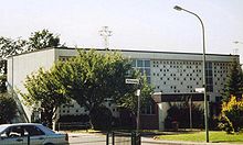
St. John Baptist
Wilhelmshöhe, together with Hueche, form the parish of Hueche in the Deanery of Eschweiler. The foundation stone of the church was laid in 1960. Before that, the Weisweiler priest visited Hüelte on Sundays for holy mass, which was held first in a Nissen hut and later in the gym of the elementary school. On September 2, 1962, the church was consecrated and on March 7, 1973 the parish vicarie was elevated to the parish of St. John Baptist .
traffic
Wilhelmshöhe is located directly on the B 264 between Eschweiler and Langerwehe, which now runs a little further north as "Kölner Straße". The old B 264 is called Langerweher Straße . The next motorway junction is Eschweiler-Ost on the A 4 .
The next train station is the Euregiobahn stop "Eschweiler-Weisweiler". Via the stops "Am Schildchen", "Heidesiedlung", "Hermann-Löns-Straße", "Langerweher Straße", "St. Johannes", "Tannenbergstraße", "Wasserfeld", "Weißer Weg", "Wilhelmshöhe" and "Ziegelei" "Wilhelmshöhe is connected by the lines 96/296, 28 and 52 with Langerwehe, Hüächen, Weisweiler and" Eschweiler Bushof ".
Heidesiedlung
The Heidesiedlung is located at the eastern end of the village towards Langerwehe. Originally it was called "Schlageter-Siedlung" after the German free corps fighter Albert Leo Schlageter . The name was changed to "Heidesiedlung" on April 15, 1946.
Web links
Coordinates: 50 ° 49 ' N , 6 ° 19' E


