Zemplínsky Branč: Difference between revisions
Content deleted Content added
m unapproved bot, blanking sections |
Username6892 (talk | contribs) Added {{Unreferenced}} tag |
||
| Line 1: | Line 1: | ||
{{Unreferenced|date=June 2023}} |
|||
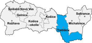
[[Image:Okres trebisov.png|thumb|right|300px|Location of Trebišov District in the [[Region]]]] |
[[Image:Okres trebisov.png|thumb|right|300px|Location of Trebišov District in the [[Region]]]] |
||
'''Zemplínsky Branč''' ({{lang-hu|Barancs}}) is a [[village]] and [[municipality]] in the [[Trebišov District]] in the [[Košice Region]] of south-eastern [[Slovakia]]. |
'''Zemplínsky Branč''' ({{lang-hu|Barancs}}) is a [[village]] and [[municipality]] in the [[Trebišov District]] in the [[Košice Region]] of south-eastern [[Slovakia]]. |
||
Latest revision as of 22:19, 3 June 2023

Zemplínsky Branč (Hungarian: Barancs) is a village and municipality in the Trebišov District in the Košice Region of south-eastern Slovakia.
History[edit]
In historical records the village was first mentioned in 1273.
Geography[edit]
The village lies at an altitude of 113 metres and covers an area of 470 km². It has a population of about 470 people.
Ethnicity[edit]
The village is about 90% Slovak.
Facilities[edit]
The village has a public library and a football pitch
External links[edit]
48°33′N 21°44′E / 48.550°N 21.733°E
