Malé Ozorovce: Difference between revisions
Content deleted Content added
m unapproved bot blanking sections |
m #article-add-desc Tags: Mobile edit Mobile app edit iOS app edit |
||
| Line 1: | Line 1: | ||
{{Short description|Village and municipality in Slovakia}} |
|||
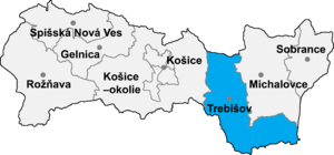
[[Image:Okres trebisov.png|thumb|right|300px|Location of Trebišov District in the [[Region]]]] |
[[Image:Okres trebisov.png|thumb|right|300px|Location of Trebišov District in the [[Region]]]] |
||
'''Malé Ozorovce''' ({{lang-hu|Kisazar}}) is a [[village]] and [[municipality]] in the [[Trebišov District]] in the [[Košice Region]] of south-eastern [[Slovakia]]. |
'''Malé Ozorovce''' ({{lang-hu|Kisazar}}) is a [[village]] and [[municipality]] in the [[Trebišov District]] in the [[Košice Region]] of south-eastern [[Slovakia]]. |
||
Revision as of 13:23, 5 March 2024

Malé Ozorovce (Hungarian: Kisazar) is a village and municipality in the Trebišov District in the Košice Region of south-eastern Slovakia.
History
In historical records the village was first mentioned in 1332.
Geography
The village lies at an altitude of 197 metres (646 ft) and covers an area of 17.082 km² (4221 acres). It has a population of about 565 people.
Ethnicity
The village is almost 100% Slovak.
Facilities
The village has a public library and a football pitch.
External links
48°41′N 21°37′E / 48.683°N 21.617°E
