Plechotice: Difference between revisions
Content deleted Content added
→Geography: Added height conversion Tags: Mobile edit Mobile web edit Advanced mobile edit |
m add authority control |
||
| Line 9: | Line 9: | ||
==Geography== |
==Geography== |
||
The [[village]] lies at an [[altitude]] of {{convert|142|m|ft}} and covers an [[area]] of 12.936 |
The [[village]] lies at an [[altitude]] of {{convert|142|m|ft}} and covers an [[area]] of 12.936 km². |
||
It has a [[population]] of about 775 people. |
It has a [[population]] of about 775 people. |
||
| Line 25: | Line 25: | ||
{{Trebisov District}} |
{{Trebisov District}} |
||
| ⚫ | |||
{{coord|48|38|N|21|38|E|region:SK_type:city|display=title}} |
{{coord|48|38|N|21|38|E|region:SK_type:city|display=title}} |
||
{{authority control}} |
|||
[[Category:Villages and municipalities in Trebišov District]] |
[[Category:Villages and municipalities in Trebišov District]] |
||
| ⚫ | |||
Revision as of 03:58, 1 April 2020

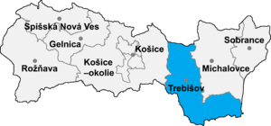
Plechotice (Hungarian: Pelejte) is a village and municipality in the Trebišov District in the Košice Region of south-eastern Slovakia.
Etymology
The name comes from the Slovak plechota—a land without vegetation.[1] 1332 Pellechte.[1]
History
In historical records the village was first mentioned in 1324.
Geography
The village lies at an altitude of 142 metres (466 ft) and covers an area of 12.936 km². It has a population of about 775 people.
Ethnicity
The village is about 99% Slovak.
Facilities
The village has a public library and a football pitch
References
- ^ a b Krajčovič, Rudolf (2014). "Z lexiky stredovekej slovenčiny s výkladmi názvov obcí a miest (48)". Kultúra slova (in Slovak) (6). Martin: Vydavateľstvo Matice slovenskej: 334.
External links
48°38′N 21°38′E / 48.633°N 21.633°E
