
Great Ocean Road
Great Ocean Road Surfcoast Highway | |
|---|---|
| The Great Ocean Road from Teddys Lookout in Lorne Formerly | |
 | |
| General information | |
| Type | Error: unknown |type= value (help) |
| Length | 243 km (151 mi) |
| Opened | 1932 |
| Location(s) | |
| via | Torquay, Anglesea, Aireys Inlet, Lorne, Apollo Bay,Lavers Hill, Port Campbell, Peterborough |
The Great Ocean Road is a 273 km stretch of road along the south-eastern coast of Australia between the Victorian cities of Torquay and Warrnambool.[1] The road was constructed as a Memorial to those killed in the First World War.[2] It is one of Australia's great scenic coastline drives.
Location
The Great Ocean Road starts at Torquay and travels westward to the outskirts of Warrnambool. The road forms about 90% of B100 (previously designated as State Route 100), the remaining 10% known as the Surfcoast Highway which joins Geelong to Torquay.
History
The Great Ocean Road was built by 3000 returned servicemen (or "Diggers") as a war memorial for fellow servicemen who had been killed in the First World War.
The idea for the road was suggested as far back as 1864. Surveying began in 1918 and construction took place between 1919 and 1932.
Parts of the Great Ocean Road run around steep coastal mountains. These were the trickiest and the final sections to be built.
In 1922 the section from Eastern View to Lorne was completed.
In 1932 the section from Lorne to Apollo Bay was finished, thus completing the entire road.
Coastal sections
Much of the road hugs the coast tightly, offering outstanding views of Bass Strait and the Southern Ocean.
Between Anglesea and Apollo Bay is a particularly scenic stretch of road which passes through many towns where mountains meet the sea. The main beach in Lorne offers great views of Louttit Bay nestled in a natural amphitheatre of hills, and Teddy's Lookout is not far from the main street.
The section near Port Campbell provides access by foot or helicopter to some of the most scenic coastline in the world, because of its striking and dramatic natural limestone and sandstone rock formations. These formations have been created by erosion from waves and rain and include Loch Ard Gorge, the Grotto, London Bridge (renamed to London Arch after the 'bridge' partly collapsed), and most famously the Twelve Apostles.
Mountain and forest sections
Around Lorne there are many forest walks which visit impressive waterfalls. Erskine Falls is a 15 minute drive inland from Lorne. Kennett River is a popular spot for koala spotting.
Between Apollo Bay and Gellibrand Lower, the road passes through the Great Otway National Park, which includes some of the last surviving temperate rainforests in the south of Australia. A walk at Mait's Rest offers spectacular views of tree-ferns and Myrtle Beeches.
After Lavers Hill is Melba Gully State Park which includes a 40-minute walk through tree ferns, Myrtle Beeches, Australian Blackwoods, passing a giant Otway Messmate and beautiful river cascades. If you return at night with a spotlight you will see thousands of Arachnocampa glowworms.
Speed limits
The road's speed limit varies from 80 kmh (50 mph) to 100 kmh (62 mph) out of urban areas. However, its sharp curves make it difficult to maintain those speeds. It is a two lane roadway (one lane in each direction). Urban area speed limits vary from 50 kmh (31 mph) to 70 kmh (43 mph). There are speed cameras at intervals along the road.
Gallery of sights and tourist landmarks
-
 Great Ocean Road
 -
Twelve Apostles
-
 Elephant Rock
 -
 The Blowhole
 -
The Grotto
-
 London Arch (formerly known as London Bridge before collapse of land section)
 -
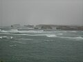 Rough seas batter rock formations along the Great Ocean Road
 -
 A secluded bay along the Great Ocean Road
 -
 Rock arch and rough seas along the Great Ocean Road
 -
 Blowhole
 -
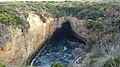 Thunder cave


See also
- Howard Hitchcock
- Highways in Victoria
- Loch Ard Gorge
- The Grotto
- London Arch
- The Twelve Apostles, Victoria
- Great Ocean Walk
References
This article needs additional citations for verification. (May 2008) |
External links
- Official Great Ocean Road website
- Great Ocean Road Accommodation & Travel Information
- Great Ocean Road Travel Guide Information on all the towns located on the Great Ocean Road.