
Bajany

Bajany (1370 Bajanhaza, 1439 Bayan, 1556 Rejdowa, 1786 Bonyesty, 1686 Resdowa) (German: Wajon; Hungarian: Bajánháza) is a village and municipality in the Michalovce District in the Košice Region of Slovakia.
History[edit]
In historical records, the village was first mentioned in 1370. From 1939 to 1944 it belonged to Hungary.
Geography[edit]
The village lies at an altitude of 107 metres and covers an area of 5.54 km2 (2.14 sq mi) (2020-06-30/-07-01).[1]
Population[edit]
It has a population of 452 people (2020-12-31).[2]
Genealogical resources[edit]
The records for genealogical research are available at the state archive "Statny Archiv in Presov, Slovakia"
- Roman Catholic church records (births/marriages/deaths): 1869-1896
- Greek Catholic church records (births/marriages/deaths): 1792-1896
- Reformated church records (births/marriages/deaths): missing records 1800s (parish A)
- Census records 1869 of Bajany are available at the state archive.(UNG county...)
Gallery[edit]
-
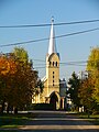 Reformed church in Bajany, built in Gothic Revival style, est. 1936
 -
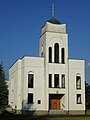 Saints Cyril and Methodius Church in Bajany, est. 1992
 -
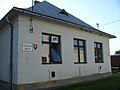 Primary school in Bajany
 -
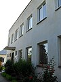 Kindergarten in Bajany
 -
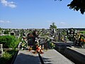 Cemetery in Bajany
 -
 Traditionall ribbed wagon on public display


See also[edit]
- List of municipalities and towns in Michalovce District
- List of municipalities and towns in Slovakia
References[edit]
- ^ "Statistic of Slovak places by Dušan Kreheľ – Export". Archived from the original on 2021-06-27. Retrieved 2021-07-05.
- ^ "Statistic of Slovak places by Dušan Kreheľ – Export". Archived from the original on 2021-06-09. Retrieved 2021-07-05.
External links[edit]
Wikimedia Commons has media related to Bajany.
48°36′N 22°07′E / 48.600°N 22.117°E
This Michalovce District geography article is a stub. You can help Wikipedia by expanding it. |