Pavlovce nad Uhom
| Pavlovce nad Uhom | ||
|---|---|---|
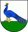
| coat of arms | map | |

|
|
|
| Basic data | ||
| State : | Slovakia | |
| Kraj : | Košický kraj | |
| Okres : | Michalovce | |
| Region : | Dolný Zemplín | |
| Area : | 33.420 km² | |
| Residents : | 4,687 (Dec. 31, 2019) | |
| Population density : | 140 inhabitants per km² | |
| Height : | 108 m nm | |
| Postal code : | 072 14 | |
| Telephone code : | 0 56 | |
| Geographic location : | 48 ° 37 ' N , 22 ° 4' E | |
| License plate : | MI | |
| Kód obce : | 522872 | |
| structure | ||
| Community type : | local community | |
| Structure of the municipality: | 3 parts of the community | |
| Administration (as of November 2018) | ||
| Mayor : | Anton Kocela | |
| Address: | Obecný úrad Pavlovce nad Uhom Kostolné námestie 1 07214 Pavlovce nad Uhom |
|
| Website: | www.pavlovce.sk | |
| Statistics information on statistics.sk | ||
Pavlovce nad Uhom (until 1927 “Pavlovce” in Slovak; Pálóc in Hungarian ) is a municipality in eastern Slovakia , near the border with Ukraine .
It is located in the east of the Eastern Slovak Lowlands on the Uh River , 9 km from Veľké Kapušany and 20 km from Michalovce .
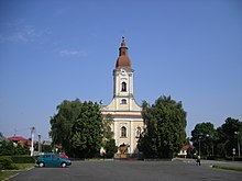
It was first mentioned in writing in 1327. The late Baroque Roman Catholic Church of St. John the Baptist from 1793 and a Greek Catholic Church from 1892 are worth seeing .
In addition to the main town, the municipality also includes the settlements Ťahyňa (incorporated in 1960) and Ortov .
Web links
Commons : Pavlovce nad Uhom - collection of pictures, videos and audio files

