Kaluža (Slovakia)
| Kaluža | ||
|---|---|---|
| coat of arms | map | |

|
|
|
| Basic data | ||
| State : | Slovakia | |
| Kraj : | Košický kraj | |
| Okres : | Michalovce | |
| Region : | Dolný Zemplín | |
| Area : | 9.891 km² | |
| Residents : | 424 (Dec. 31, 2019) | |
| Population density : | 43 inhabitants per km² | |
| Height : | 120 m nm | |
| Postal code : | 072 36 | |
| Telephone code : | 0 56 | |
| Geographic location : | 48 ° 48 ' N , 22 ° 0' E | |
| License plate : | MI | |
| Kód obce : | 522589 | |
| structure | ||
| Community type : | local community | |
| Administration (as of November 2018) | ||
| Mayor : | Jana Macejková | |
| Address: | Obecný úrad Kaluža č. 4 072 36 Kaluža |
|
| Website: | www.kaluza.sk | |
| Statistics information on statistics.sk | ||
Kaluža (until 1927 Slovak "Kalusa"; Hungarian Ungtavas - until 1907 Kalusa or Kalussa ) is a municipality in the east of Slovakia , with 424 inhabitants (December 31, 2019) that the Michalovce District of, part kraj Košický heard and in the traditional Zemplín landscape .
geography
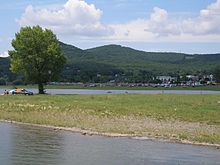
The municipality is located in the northern part of the Eastern Slovak Lowlands at the foot of the Vihorlat Mountains to the north, on the northern bank of the Zemplínska šírava reservoir . The center of the village lies at an altitude of 120 m nm and is 10 kilometers away from Michalovce .
Neighboring communities are Valaškovce (military area) in the north, Klokočov in the east, Lúčky in the southeast, Hažín in the south and Vinné in the west.
history
Kaluža was first mentioned in writing as Kalasamezow in 1336 and was part of the domain of Großmichel. According to a tax register, there were 16 portals in 1427 . Two households lived here in 1715 and six in 1720. In 1715 there were vineyards in the municipality. In 1828 there were 61 houses and 405 residents who were employed as farmers and forest workers. The forests were owned by the Sztáray family until the 20th century .
Until 1918/1919 the place in Ung County belonged to the Kingdom of Hungary and then came to Czechoslovakia or now Slovakia.
population
According to the 2011 census, Kaluža had 358 inhabitants, including 328 Slovaks , two Russians and one Ukrainian . 27 residents did not provide any information on ethnicity .
200 residents committed to the Greek Catholic Church, 78 residents to the Roman Catholic Church, six residents to the Orthodox Church, five residents to the Evangelical Church AB, four residents to the Brethren and one resident to the Jehovah's Witnesses; one resident professed a different denomination. 30 residents had no denomination and 33 residents had no denomination.
Buildings
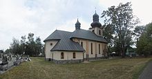
- Greek Catholic Church
tourism
Kaluža is an important tourist place on the north bank of the Zemplínska šírava, especially in summer, with three recreational areas: on the Medvedia hora peninsula as well as Kaluža and Kamenec . In 2014 the year-round thermal park Šírava was opened in Medvedia hora .
traffic
The 2nd order road 582 (Michalovce - Jovsa - Sobrance ) runs through Kaluža and has four lanes from Michalovce to here. The nearest train station is also in Michalovce, on the Michaľany – Łupków railway line .
Individual evidence
- ↑ Results of the 2011 census (Slovak) ( Memento of the original from March 5, 2016 in the Internet Archive ) Info: The archive link was inserted automatically and has not yet been checked. Please check the original and archive link according to the instructions and then remove this notice.
- ↑ Šírava Thermal Park, slovakia.travel, accessed on June 24, 2019
Web links
- Entry on e-obce.sk (Slovak)


