Žibritov
| Žibritov | ||
|---|---|---|
| coat of arms | map | |

|
|
|
| Basic data | ||
| State : | Slovakia | |
| Kraj : | Banskobystrický kraj | |
| Okres : | Krupina | |
| Region : | Poiplie | |
| Area : | 9,957 km² | |
| Residents : | 61 (Dec. 31, 2019) | |
| Population density : | 6 inhabitants per km² | |
| Height : | 494 m nm | |
| Postal code : | 963 01 ( Krupina Post Office ) | |
| Telephone code : | 0 45 | |
| Geographic location : | 48 ° 24 ' N , 18 ° 59' E | |
| License plate : | KA | |
| Kód obce : | 518999 | |
| structure | ||
| Community type : | local community | |
| Administration (as of November 2018) | ||
| Mayor : | Dušan Laco | |
| Address: | Obecný úrad Žibritov č. 12 963 01 Krupina |
|
| Statistics information on statistics.sk | ||
Žibritov (Hungarian Zsibritó ) is a municipality in the center of Slovakia with 61 inhabitants (as of December 31, 2019), which is located in Okres Krupina , a district of Banskobystrický kraj .
geography
The community is located in the eastern part of the Schemnitz Mountains on the upper reaches of the Bebrava stream , a right-hand tributary of the Krupinica . South of the village is the natural monument Krupinské bralce (also called Štangarígel ), a formation of pentagonal andesite columns. The center of the village lies at an altitude of 494 m nm and is nine kilometers from Krupina (road distance).
Neighboring municipalities are Svätý Anton in the west and north, Krupina in the east, Kráľovce-Krnišov in the south and Prenčov in the southwest.
history
Žibritov was first mentioned in writing in 1266 as Seurdfolua or Seweret , other historical names include Sebrethfolua (1342) and Žibritowce (1773). In 1342 the village was owned by the Litava Castle , from the first half of the 16th century by the Sitno Castle , in 1629 it was owned by the Koháry family and in the 19th century by the Coburg family. In 1576 the community was destroyed by the Ottoman troops, in 1582 (other sources speak of 1586) a small fortification was built here. In 1715 the village had a mill and 31 households with a tradition of charcoal burning. In 1828 there were 38 houses and 233 residents who were employed as farmers, cattle keepers and forest workers.
Until 1918 the place in Hont County belonged to the Kingdom of Hungary and then came to Czechoslovakia or now Slovakia.
population
According to the 2011 census, Žibritov had 69 inhabitants, 64 of whom were Slovaks . Four residents stated a different ethnic group and one resident gave no information about the ethnic group.
34 residents professed to the Roman Catholic Church and 31 residents to the Evangelical Church AB. Three residents were non-denominational and the denomination of one resident was not determined.
Buildings and monuments
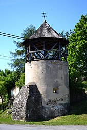
- Ruins of a fortification that was created through the reconstruction of the late medieval Ladislaus Church in 1582/1586. Today only the former bastion remains, which was later rededicated as a bell tower. Until 2009 there was a bell from the workshop of the Viennese metal foundry Balthasar Herold from 1680.
- Protestant church from 1838
Individual evidence
- ↑ Slovenské slovníky: názvy obcí Slovenskej republiky (Majtán 1998)
- ↑ Prírodná pamiatka Krupinské bralce , enviroportal.sk, accessed on May 13, 2018
- ↑ Results of the 2011 census (Slovak)
- ↑ Žibritov , apsida.sk, accessed on May 13, 2018
Web links
- Entry on e-obce.sk (Slovak)


