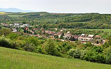
Ladzany
| Ladzany | ||
|---|---|---|
| coat of arms | map | |

|
|
|
| Basic data | ||
| State : | Slovakia | |
| Kraj : | Banskobystrický kraj | |
| Okres : | Krupina | |
| Region : | Poiplie | |
| Area : | 26.517 km² | |
| Residents : | 263 (Dec. 31, 2019) | |
| Population density : | 10 inhabitants per km² | |
| Height : | 216 m nm | |
| Postal code : | 962 65 (Post Office Hontianske Nemce ) | |
| Telephone code : | 0 45 | |
| Geographic location : | 48 ° 16 ' N , 18 ° 54' E | |
| License plate : | KA | |
| Kód obce : | 518573 | |
| structure | ||
| Community type : | local community | |
| Administration (as of November 2018) | ||
| Mayor : | Miloš Čmela | |
| Address: | Obecný úrad Ladzany č. 109 962 65 Hontianske Nemce |
|
| Website: | www.ladzany.sk | |
| Statistics information on statistics.sk | ||
Ladzany (German Lasan , Hungarian Ledény ) is a municipality in the center of Slovakia with 263 inhabitants (as of December 31, 2019), which is located in Okres Krupina , a district of Banskobystrický kraj .
geography
The community is located at the foot of the Schemnica Mountains in the Klastavský potok valley , and it also has a share in the Krupinská planina plateau . The center of the village is at an altitude of 216 m nm and is 19 kilometers from Krupina and 29 kilometers from Levice .
Neighboring communities are Baďan and Beluj in the north, Sebechleby in the east, Drážovce in the south, Lišov in the south-west, Bátovce in the west and Pečenice and Jabloňovce in the north-west.
history
Today's municipality had a settlement of the Lengyel culture in the Neolithic Age , there are also finds from the older Bronze Age and remains of a settlement and burial site of the Lusatian culture .
Ladzany was first mentioned in writing in 1233 as Lengen . In the 14th century the village was under the rule of Litava Castle , in the 18th century it was owned by the Géczy and Török families . In 1715 Ladzany had 46 households, in 1828 there were 113 houses and 680 inhabitants; The main sources of income were agriculture, viticulture and especially fruit growing.
Until 1918 the place in Hont County belonged to the Kingdom of Hungary and then came to Czechoslovakia or now Slovakia.
population
According to the 2011 census, Ladzany had 309 inhabitants, including 289 Slovaks, 12 Roma, 4 Czechs and 2 Poles. 2 residents stated a different ethnic group. 152 residents supported the Evangelical Church AB and 123 residents supported the Roman Catholic Church; 1 resident confessed to another denomination. 21 residents had no denomination and the denomination of 12 residents was not determined.
Buildings and monuments
- Protestant church from the 13th century, originally designed in the Romanesque style, Gothicized in the 15th century and redesigned again in the 18th century. In addition to Gothic architectural details, a Gothic baptismal font and a Renaissance painting from the 2nd half of the 16th century are noteworthy.
- Memorial plaque for Andrej Sládkovič
traffic
The 1st order road 51 runs through Ladzany on the Levice – Hontianske Nemce section . A 3rd order road branching off to the south leads to Hontianske Tesáre .
The nearest train station with regular passenger traffic is Levice on the Nové Zámky – Zvolen railway, 30 kilometers away.
Individual evidence
- ↑ Results of the 2011 census (Slovak) ( Memento of the original from March 5, 2016 in the Internet Archive ) Info: The archive link was inserted automatically and has not yet been checked. Please check the original and archive link according to the instructions and then remove this notice.
Web links
- Entry on e-obce.sk (Slovak)


