Alcalá la Real
| Alcalá la Real municipality | ||
|---|---|---|
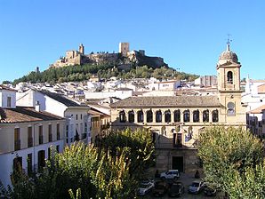
 The fortress La Mota, in the foreground the town hall
|
||
| coat of arms | Map of Spain | |

|
|
|
| Basic data | ||
| Autonomous Community : | Andalusia | |
| Province : | Jaén | |
| Comarca : | Sierra Sur | |
| Coordinates | 37 ° 28 ′ N , 3 ° 56 ′ W | |
| Height : | 918 msnm | |
| Area : | 261.36 km² | |
| Residents : | 21,605 (Jan 1, 2019) | |
| Population density : | 82.66 inhabitants / km² | |
| Postal code : | 23680 | |
| Municipality number ( INE ): | 23002 | |
| administration | ||
| Mayoress : | Elena Víboras Jiménez ( PSOE ) | |
| Website : | www.alcalalareal.es | |
| Location of the municipality | ||

|
||
Alcalá la Real is a Spanish city in the province of Jaén with 21,605 inhabitants, 71 km from Jaén and 53 km from Granada . The city is known for olive and cherry production.
politics
| Political party | 2011 | 2015 | ||
|---|---|---|---|---|
| Be right % | Seats | Be right % | Seats | |
| PSOE | 46.41% | 11 | -% | - |
| PP | 39.28% | 9 | -% | - |
| IU | 7.21% | 1 | -% | - |
Population development

Personalities
- Juan Martínez Montañés (1568–1649), sculptor
- Amparo Sánchez (* 1969), singer
Town twinning
Web links
Commons : Alcalá la Real - collection of images, videos and audio files
Individual evidence
- ↑ Cifras oficiales de población resultantes de la revisión del Padrón municipal a 1 de enero . Population statistics from the Instituto Nacional de Estadística (population update).
- ^ Elecciones Locales 2011 Results of the municipal council elections 2011 from the Spanish Ministry of the Interior on elecciones.mir.es (Spanish)
