Baños de la Encina
| Baños de la Encina municipality | ||
|---|---|---|
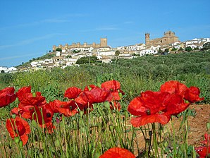
 Baños de la Encina - castle and place
|
||
| coat of arms | Map of Spain | |

|
|
|
| Basic data | ||
| Autonomous Community : |
|
|
| Province : | Jaén | |
| Comarca : | Sierra Morena | |
| Coordinates | 38 ° 11 ′ N , 3 ° 46 ′ W | |
| Height : | 450 msnm | |
| Area : | 392.27 km² | |
| Residents : | 2,582 (Jan 1, 2019) | |
| Population density : | 6.58 inhabitants / km² | |
| Postal code : | 23711 | |
| Municipality number ( INE ): | 23011 | |
| administration | ||
| Website : | Baños de la Encina | |
Baños de la Encina is a town in southern Spain and a municipality ( municipio ) consisting of the main town and several hamlets with a total of 2,582 inhabitants (as of January 1, 2019) in the west of the province of Jaén in the autonomous region of Andalusia . The center of the village is recognized as a conjunto histórico-artístico .
location
The place Baños de la Encina is located in the Sierra Morena almost 70 km (driving distance) north of the provincial capital Jaén at an altitude of approx. 400 to 460 m above sea level. d. The climate in winter is temperate, in summer it is warm to hot; the low amounts of precipitation (approx. 470 mm / year) fall - with the exception of the almost rainless summer months - distributed over the whole year.
Population development
| year | 1857 | 1900 | 1950 | 2000 | 2016 |
| Residents | 2,601 | 3,922 | 6,521 | 2,721 | 2,634 |
The significant population decline in the second half of the 20th century is mainly due to the almost exclusive planting of olive trees, the mechanization that goes with it and the resulting loss of jobs.
economy
Baños de la Encina is located in the northwest of the seemingly endless olive tree plantations of the Jaén province. In the past, cereals, vines, etc. were also planted for self-sufficiency ; Vegetables came from the house gardens. Small traders, craftsmen and service companies of all kinds have settled in the village. There are also several holiday homes (casas rurales) .
history
Small finds from the Neolithic and Bronze Age were discovered in the municipality ; Iberian finds are missing. The remains of the foundations of a country estate ( villa rustica ) date from Roman times . The Visigoths , however, left no traces. At the beginning of the 8th century the area was overrun by the Moors . During the caliphate of Cordoba , a first fortress (hisn) was built under al-Hakam II (r. 961–976 ) . After the end of the Caliphate of Cordoba (1031), the area became part of the Taifa Kingdom of Jaén. Around the middle of the 12th century Baños fell briefly to the Christians, but shortly afterwards it was incorporated into the newly formed Almohad Empire, which, after its defeat in the Battle of Las Navas de Tolosa (1212), was increasingly attacked by its Muslims ( Ibn Hud , Muhammad I. ibn Nasr ) and Christian neighbors exposed. Already around the year 1225 Baños was by the Christians under Ferdinand III. recaptured by Castile ( reconquista ) and incorporated into the newly created Kingdom of Jaén , which was, however, closely connected to the Crown of Castile and did not appear politically. The place was administered by the Order of Santiago , who also renewed the castle (castillo) . The expulsion of the Jews began with the Alhambra Edict (1492) of the Catholic Kings ; in the years around 1610 the last Muslims ( moriscos ) were also expelled. In 1626 Baños received city rights.
Attractions
- The Castillo de Burgalimar, or rather the Castillo de Bury Al-Hamma, is considered to be one of the oldest, at least partially preserved, castles in Europe. The complex, which has a floor area of approx. 2700 m², is oval-shaped, approx. 100 m long and a maximum of approx. 46 m wide. In addition to a rounded keep (torre del homenaje) there are 14 side towers on a square floor plan. The original castle walls were made of rammed earth mixed with small stones; later, parts of the outer walls and above all the battlements were replaced with stone blocks. Inside the castle area were the rooms for the guards and the stables, which were probably made of wooden posts, later constructed from half-timbered houses ; the water supply was ensured by cisterns (aljibes) .
- The Iglesia de San Mateo was built in the 16th and 17th centuries. The nave is spanned by a rib vault. The old altarpiece was destroyed in the Spanish Civil War; the current one is the work of the sculptor Francisco Palma Burgos.
- The Casa Salido was the city palace of a noble family and was built in the 17th century.
- Surroundings
- The Ermita del Cristo del Llano, elevated by a three-part bell gable (espadaña), dates from the end of the 17th century; in 1744 a richly decorated baroque camarín was added.
- The Bronze Age settlement of Peñalosa , located approx. 2 km west of the village and discovered and excavated in the 1980s, was built around 1700 BC. Chr .; it impresses with its location on the reservoir of the Rio Rumblar and its layered natural stone walls .
- In the hamlet of El Centenillo , about 18 km north of the village, there was once a Roman ore mine.
Web links
- Baños de la Encina, places of interest - photos + information (Spanish)
- Baños de la Encina, history and places of interest - photos + quick facts (Spanish)
Individual evidence
- ↑ Cifras oficiales de población resultantes de la revisión del Padrón municipal a 1 de enero . Population statistics from the Instituto Nacional de Estadística (population update).
- ↑ Baños de la Encina - Map with altitude information
- ↑ Baños de la Encina - Climate tables
- ↑ Baños de la Encina - population development
- ↑ Baños de la Encina - Economy etc.
- ↑ Baños de la Encina - History
- ↑ Baños de la Encina - Castillo
- ↑ Baños de la Encina - Iglesia
- ↑ Baños de la Encina - Ermita
- ↑ Baños de la Encina - Ermita
- ↑ Baños de la Encina - Peñalosa
- ↑ Baños de la Encina - El Centenillo


