Barwice
| Barwice | ||
|---|---|---|

|
|
|
| Basic data | ||
| State : | Poland | |
| Voivodeship : | West Pomerania | |
| Powiat : | Szczecinek | |
| Area : | 7.42 km² | |
| Geographic location : | 53 ° 45 ' N , 16 ° 21' E | |
| Height : | 143 m npm | |
| Residents : | 3715 (June 30, 2019) |
|
| Postal code : | 78-460 | |
| Telephone code : | (+48) 94 | |
| License plate : | ZSZ | |
| Economy and Transport | ||
| Street : | Ext. 171 Bobolice ↔ Czaplinek | |
| Ext. 172 Połczyn-Zdrój ↔ Szczecinek | ||
| Rail route : | no train tail | |
| Next international airport : | Szczecin-Goleniów | |
| Gmina | ||
| Gminatype: | Urban and rural municipality | |
| Gmina structure: | 48 villages | |
| 20 school offices | ||
| Surface: | 258.89 km² | |
| Residents: | 8565 (Jun. 30, 2019) |
|
| Population density : | 33 inhabitants / km² | |
| Community number ( GUS ): | 3215023 | |
| Administration (as of 2011) | ||
| Mayor : | Zenon Maksalon | |
| Address: | ul.Zwycięzców 22 78-460 Barwice |
|
| Website : | www.barwice.pl | |
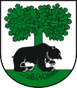
Barwice ( German Bärwalde ) is a city in the Polish West Pomeranian Voivodeship . The small town (about 4000 inhabitants) is the seat of a town and rural municipality in the Powiat Szczecinecki ( Neustettiner Kreis ).
Geographical location

The city is located in Western Pomerania in an elongated meadow valley, about 22 kilometers west of Neustettin ( Szczecinek ) and 50 kilometers south of Köslin ( Koszalin ).
The Draheimer Seenplatte begins about 20 kilometers further south .
history
The Wendish settlement civitas Barwitz was first mentioned in 1286.
In 1389 Hans Hechhusen and Reimer Pudwelsch were named as the owners of the town.
Under Duke Bogislaw X. the city and the villages belonging to it came to Pomerania in 1477 . Bärwalde was in the changing ownership of various Pomeranian aristocratic families, such as the four families of Glasenapp , Münchow , Wolde and Zastrow , to whom the land of Bärwalde and the Pileburg Heath jointly belonged from 1523.
Duke Johann Friedrich von Pomerania promoted the city and granted it the privileges to hold annual fairs in 1569, 1592 and 1597. The years of disputes between the aristocratic manor and the city council over jurisdiction in Bärwalde were settled in 1620 in favor of the manor. In 1626 a city fire destroyed the city.
During the Thirty Years War it was occupied by the Swedish troops of Gustav II Adolf in 1630 . The city suffered severe damage. When the Pomeranian ruling family died out, Bärwalde came under Brandenburg rule in 1653 .
During the Seven Years' War , Russian troops plundered and pillaged the city; all town documents were lost in the process. In 1766 Bärwalz was granted the right to hold a fourth annual fair. At that time the city had four gates, but was not walled. In the 18th century, its inhabitants lived from cloth and linen making as well as from agriculture. The cloth making trade died in the 19th century, instead dyeing and textile printing works were established. After the Prussian administrative reform, Bärwalde belonged to the Neustettin district from 1818 .
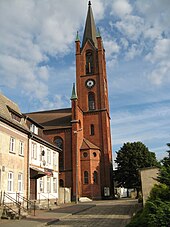
In 1854 the new construction of the town church, St. Stephen, began, which was completed after ten years. The neo-Gothic building made of red brick has a slender tower, which is equipped with three disc clocks and a bell. The interior of the nave is characterized by galleries and two rows of wooden posts that support the wooden mansard roof . The old church, which was partly from the end of the 13th century, was completely demolished in the course of the new building. At the beginning of the 20th century, Bärwalde had a synagogue and a district court in addition to the Protestant town church .
It was not until 1903 that Bärwalde was connected to the railway network with the line between Polzin and Gramenz . The station was laid out north of the city (today the former station is inhabited), and after the First World War the city expanded in its direction.
The new transport connection led to the establishment of new industrial companies, e.g. B. a machine and a sand-lime brick factory. Later it was planned to connect Bärwalde to the Reichsautobahn Berlin – Königsberg , which could not be completed due to the Second World War . The last remnants of the route that ends there are visible from the air southeast of the city.
During the Second World War , Bärwalde was hardly affected by direct acts of war. Occasionally, Soviet bombers flew over the city on their way to Szczecin . Some residents used the train station to flee to the west. After the end of the war, the Soviet Union placed Bärwalde together with all of Western Pomerania under the administration of the People's Republic of Poland . Bärwalde received the Polish name Barwice . After that, the gradual immigration of Polish migrants began, some of whom came from areas east of the Curzon Line , where they had belonged to the Polish minority. The remaining native German population was subsequently expelled from the city by the local Polish administrative authority .
Demographics
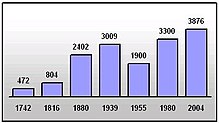
| year | population | Remarks |
|---|---|---|
| 1740 | 472 | |
| 1783 | 533 | including six Jews. |
| 1791 | 651 | seven of them Jews |
| 1802 | 666 | |
| 1812 | 804 | including six Catholics and 34 Jews. |
| 1816 | 854 | 790 Protestants, five Catholics and 59 Jews |
| 1821 | 926 | |
| 1831 | 1180 | including six Catholics and 85 Jews. |
| 1843 | 1571 | including three Catholics and 129 Jews. |
| 1852 | 1741 | including four Catholics and 143 Jews. |
| 1861 | 1964 | eight Catholics and 180 Jews. |
| 1875 | 2264 | |
| 1880 | 2402 | |
| 1890 | 2307 | 104 of them Jews |
| 1900 | 2338 | almost only evangelicals |
| 1925 | 2531 | including 2,458 Evangelicals, 13 Catholics and 42 Jews |
| 1933 | 2788 | |
| 1939 | 3008 |
|
traffic
The city is connected to the neighboring towns of Szczecinek and Połczyn Zdrój via the Voivodship Road 172 ( droga wojewódzka 172 ) .
A railway connection has not existed since 1999 when the Połczyn Zdrój – Grzmiąca line was closed .
local community
In addition to the town of Barwice, the town and country municipality of Barwice includes 20 other places ( German names up to 1945 ) with a Schulzenamt:
|
Other localities in the municipality are:
|
|
|
Partner municipality
There is a partnership between the municipality of Barwice and the municipality of Malente in Germany.
sons and daughters of the town
- Johann Ernst Theodor Janke (1781–1841), German theologian, civil servant and author
- Rudolf von Manteuffel (1817–1903), Prussian lieutenant general, most recently commander of the 6th division
- Walter Langer (1877 – after 1932), German trade unionist and politician (DVP)
literature
- Gustav Kratz : The cities of the province of Pomerania - an outline of their history, mostly according to documents . Berlin 1865 (reprinted in 1996 by Sendet Reprint Verlag, Vaduz, ISBN 3-253-02734-1 ), pp. 18-19 ( full text ).
- Ludwig Wilhelm Brüggemann : Detailed description of the current state of the Königl. Prussian Duchy of Vor and Hinter Pomerania . Part II, Volume 2: Description of the court district of the Royal. State colleges in Cößlin belonging to the Eastern Pomeranian districts . Stettin 1784, pp. 711-716.
Web links
- City of Bärwalde i. Pom. (Rolf Jehke, 2011)
- The city of Bärwalde i. Pom. in the former Neustettin district in Pomerania (Gunthard Stübs and Pomeranian Research Association, 2011)
- City and municipality website (Polish)
Individual evidence
- ↑ a b population. Size and Structure by Territorial Division. As of June 30, 2019. Główny Urząd Statystyczny (GUS) (PDF files; 0.99 MiB), accessed December 24, 2019 .
- ↑ Ludwig Wilhelm Brüggemann , Ed .: Detailed description of the current state of the Royal Prussian Duchy of Western and Western Pomerania . Part II, Volume 2, Stettin 1784, pp. 711-716 .
- ↑ [1] ( Page no longer available , search in web archives ) Info: The link was automatically marked as defective. Please check the link according to the instructions and then remove this notice. , Biuletyn Informacji Publicznej Urząd Miejski w Barwicach (Bulletin for Public Information of the Barwice Municipal Office).
- ↑ a b Meyer's Large Conversation Lexicon . 6th edition, Volume 2, Leipzig and Wien 1906, p. 411.
- ↑ a b c d e f g h Kratz (1865), p. 19.
- ↑ Christian Friedrich Wutstrack , Ed .: Short historical-geographical-statistical description of the royal Prussian duchy of Vorpommern and Hinterpommern . Stettin 1793, overview table on p. 736.
- ↑ a b c Alexander August Mützell and Leopold Krug : New topographical-statistical-geographical dictionary of the Prussian state . Volume 5: T – Z , Halle 1823, pp. 250–211, paragraph 26.
- ↑ a b c d e Michael Rademacher: German administrative history from the unification of the empire in 1871 to the reunification in 1990. neustettin.html. (Online material for the dissertation, Osnabrück 2006).
- ↑ The city of Bärwalde i. Pom. in the former Neustettin district in Pomerania (Gunthard Stübs and Pomeranian Research Association, 2011)
- ↑ Road map of Hinterpommern: Köslin - Stolp - Danzig , 9th edition, Höfer Verlag, Dietzenbach 2005, ISBN 978-3-931103-14-9 .
- ↑ The Genealogical Place Directory
- ↑ List of place names of the localities beyond Oder u. Neiße, Margarete Kaemmerer, ISBN 3-7921-0368-0 , p. 45


