
Bettmeralp VS
| VS is the abbreviation for the canton of Valais in Switzerland and is used to avoid confusion with other entries in the name Bettmeralp . |
| Bettmeralp | |
|---|---|
 |
|
| State : |
|
| Canton : |
|
| District : | East of Raron |
| BFS no. : | 6205 |
| Postal code : | 3991 beds 3992 Bettmeralp 3994 Martisberg |
| Coordinates : | 647 964 / 137827 |
| Height : | 1948 m above sea level M. |
| Height range : | 948-4194 m above sea level M. |
| Area : | 28.79 km² |
| Residents: | 462 (December 31, 2018) |
| Population density : | 16 inhabitants per km² |
| Website: | municipality.bettmeralp.ch |
 Bettmeralp community |
|
| Location of the municipality | |
  |
|
Bettmeralp ( Valais German Bättmeralp ) is from the existing municipalities on 1 January 2014 beds and Martisberg resulting Munizipalgemeinde with the new FSO no. 6205 and a civic community . It is located in the Eastern Raron district in the Swiss canton of Valais . The new municipality was named after the Bettener holiday village Bettmeralp named.
geography
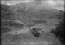
Bettmeralp is located in the Bernese Alps on the northern slope above the Rhone Valley in Upper Valais and is made up of three localities: the main village of Betten , consisting of the districts of Egga and Dorf (1203 m above sea level), the eponymous resort of Bettmeralp (1948 m above sea level) .) and the village of Martisberg (1367 m above sea level), which is made up of the main settlement Hittubodu and the former village center of Derfji. The community is part of the Unesco World Heritage Aletsch area , the highest point is at 4193 m above sea level. M. on the Aletschhorn on the border with Naters . The community is surrounded by the mountains Dreieckhorn (3811 m above sea level), Olmenhorn (3314 m above sea level), Eggishorn (2926 m above sea level) and Bettmerhorn (2872 m above sea level). The Bettmersee is located above Bettmeralp . Bettmeralp borders the Fieschertal in the north, Fiesch and Lax in the east, Grengiols and Mörel-Filet in the south and Riederalp and Naters in the west .
Land use
In 2009, the municipal area of 29.4 km 2 consisted of 17.0% of agricultural and 1.4% of settlement area. Historically, this means an increase in the settlement area since 1985 by 13 ha at the expense of the agricultural area, which decreased by 49 ha in the same period. The wooded area (i.e. wood, forest) made up 15.9%, the remaining portion was considered unproductive area.

history
The place Betten is mentioned for the first time in 1343; at that time the village with Goppisberg was part of the Zenden Ostlich-Raron. 1571 Bettmeralp (then Terpetsch ) the Anna chapel built, 125 years later, the chapel Mary of the Snow . In 1748 a rectorate was set up, but it was not occupied until 17 years later. Village fires were recorded in 1676 and 1853. In the 19th century, especially in the village of Martisberg, a wave of emigration began, with many residents emigrating to Argentina . With the onset of tourism in the 1930s, a rapid change from a farming village to a holiday destination began; economic life shifted more and more to Bettmeralp over the course of the century. The Bettmeralp community was founded in early 2014 when the former Betten and Martisberg communities merged.
population
Bettmeralp had 442 inhabitants in 219 households in 2016, of which around 86.9% were Swiss and 13.1% were foreigners. The population comprised 63 adolescents and 379 adults, 95 of whom were 65 years old or older. Nobody lived on welfare.
politics
National elections
In the 2015 National Council elections, the share of the vote in Bettmeralp was: CVP 57.3%, SVP 28.7%, SP 6.3%, Greens 4.9%, FDP 2.6%, EPP 0.2%.
Attractions
Bettmeralp is particularly known as a holiday resort. Thanks to its proximity to the Aletsch Glacier , the largest of its kind in the Alps , and an attractive ski area with a view of the cathedral and the Matterhorn , Bettmeralp is an established winter sports destination. The network of hiking trails is also family-friendly.
Also worth seeing are the Aletsch Forest with the oldest trees in the country, the Bettmersee and the Maria zum Schnee chapel in the village itself.
traffic
Bettmeralp is car-free . Both the village of Betten and the Bettmeralp tourist area can only be reached by cable car for holiday guests . The garbage truck is also transported using the cable car and can therefore only carry two tons of load with each load.
literature
- Editor: Bettmeralp. In: Historical Lexicon of Switzerland . 2017 .
- Philipp Kalbermatter: Beds. In: Historical Lexicon of Switzerland . 2017 .
- Philipp Kalbermatter: Martisberg. In: Historical Lexicon of Switzerland . 2017 .
Web links
Individual evidence
- ↑ Permanent and non-permanent resident population by year, canton, district, municipality, population type and gender (permanent resident population). In: bfs. admin.ch . Federal Statistical Office (FSO), August 31, 2019, accessed on December 22, 2019 .
- ↑ Arrival in the Aletsch Arena. aletscharena.ch.
- ↑ Car icons: Unimog, the story of a multi-talent. youtube.com.
Bettmeralp | Bister | Bitsch | Grengiols | Mörel fillet | Riederalp
Former parishes: Betten | Fillet | Goppisberg | Greich | Martisberg | Mörel | Ried-Mörel
Canton of Valais | Districts of the canton of Valais | Municipalities of the canton of Valais