Bockenemer clarification ponds
|
Bockenemer clarification ponds
|
||
| location | West of Bockenem | |
| surface | 4 ha | |
| Identifier | NSG HA 061 | |
| WDPA ID | 81427 | |
| Geographical location | 52 ° 1 ' N , 10 ° 7' E | |
|
|
||
| Sea level | from 108 m to 112 m | |
| Setup date | 06/30/1981 | |
| particularities | NLWKN | |
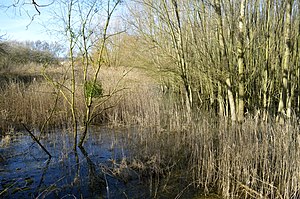
The Bockenem clearing ponds are a nature reserve in the Lower Saxon town of Bockenem in the Hildesheim district .
The nature reserve with the registration number NSG HA 061 is 4.2 hectares . It is located directly west of Bockenem on the edge of the Nette lowland and protects the former sedimentation basin of a sugar factory . The former sedimentation basins are surrounded by dams about three meters high and overgrown with bushes. The basins themselves have extensive reed areas. They are predominantly surrounded by intensively used agricultural land .
The area has been a nature reserve since June 30, 1981. The responsible lower nature conservation authority is the Hildesheim district.
Web links
Commons : Naturschutzgebiet Bockenemer Klärticheiche - collection of images, videos and audio files


