Lieth (nature reserve)
|
Lieth
|
||
| location | Northwest of Freden , Hildesheim district , Lower Saxony | |
| surface | 52 ha | |
| Identifier | NSG HA 188 | |
| WDPA ID | 164455 | |
| Geographical location | 51 ° 56 ' N , 9 ° 53' E | |
|
|
||
| Sea level | from 97 m to 177 m | |
| Setup date | August 6, 1998 | |
| administration | NLWKN | |
The Lieth is a nature reserve in the Lower Saxony municipality of Freden (Leine) and the city of Alfeld (Leine) in the district of Hildesheim .
The nature reserve with the sign NSG HA 188 is 52 hectares . The area has been a nature reserve since August 6, 1998. The responsible lower nature conservation authority is the Hildesheim district.
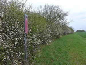
The nature reserve, which consists of five sub-areas, lies between Freden (Leine) and the districts of Imsen and Wispenstein, which belong to Alfeld (Leine) . It extends to a shell back of the triad , which for Leinetal steeply. The remnants of earlier forms of use are semi-arid lawns , orchards and coppice forests . The semi-arid lawns and orchards are covered with bushes because they are no longer cultivated. This development is partially halted and reversed through maintenance measures such as grazing or mowing . In the area of semi-arid grassland, u. a. Hain Wachtelweizen , Skabiosen- and knapweed , Hypericum and Jacobaea vulgaris , but also cross gentian , meadow sage , dyer's broom and Centaurium erythraea .
In the nature reserve, grassland areas , fallow land , arable and forest areas are included as a buffer zone to the areas worth protecting.
Web links
- Nature reserve "Lieth" in the database of the Lower Saxony State Office for Water Management, Coastal and Nature Conservation (NLWKN)
Individual evidence
- ↑ Die Lieth bei Freden , Paul Feindt Foundation. Retrieved June 19, 2018.


