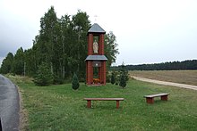
Boroszów
| Boroszów | ||
|---|---|---|

|
|
|
| Basic data | ||
| State : | Poland | |
| Voivodeship : | Opole | |
| Powiat : | Oleski | |
| Gmina : | Olesno | |
| Geographic location : | 50 ° 57 ' N , 18 ° 26' E | |
| Height : | 220-250 m npm | |
| Residents : | 272 (Dec. 31, 2015) | |
| Postal code : | 46-300 | |
| Telephone code : | (+48) 34 | |
| License plate : | OOL | |
| Economy and Transport | ||
| Street : | Ext. 487 Byczyna - Olesno | |
| Next international airport : | Katowice-Pyrzowice | |
Boroszów ( German Boroschau , 1936-1945 Alteneichen ) is a place in Upper Silesia . It is located in the urban and rural community of Olesno (Rosenberg OS) in the powiat Oleski of the Opole Voivodeship (Opole) .
geography
Geographical location
Boroszów is located in the northeastern part of Upper Silesia in the Rosenberger Land. The village of Boroszów is located about eight kilometers north of the district town of Olesno and about 55 kilometers northeast of the voivodeship capital Opole .
The place is in the Wyżyna Woźnicko-Wieluńska (Woischnik-Wieluń highlands) within the Obniżenie Liswarty (Lisswarther valley) . Boroszów There are extensive forest areas south of the village. The voivodship road DW487 runs through the village .
Neighboring places
Boroszów neighbors are Jamy (Jamm) in the west, Skrońsko (Skronskau) in the north and Bischdorf / Biskupice in the east .
history
The village was first mentioned in the 16th century. The place name is derived from the founder of the village, the village of Borosz . In 1679 a church was first mentioned in the village.
After the First Silesian War in 1742, Boroschau and most of Silesia fell to Prussia .
After the reorganization of the province of Silesia , the rural community Boroschau belonged to the district of Rosenberg OS in the administrative district of Opole from 1816 . In 1845 there was a castle, a Vorwerk, a Catholic church, a hunter's house, a brewery, a distillery and 39 houses in the village. In the same year, 303 people lived in Boroschau, 34 of them Protestants and five Jewish. In 1855 the village numbered 357 people. In 1874 the administrative district Skronskau was founded, which consisted of the rural communities Boroschau, Jastrzigowitz and Skronskau and the manor districts Boroschau and Skronskau. In 1885 Boroschau had 172 inhabitants. In 1895 Boroschau was connected to the Rosenberger Kreisbahn railway line .
In the referendum in Upper Silesia on March 20, 1921, 91 eligible voters voted for Upper Silesia to remain with Germany and 11 for membership in Poland. Groß Borek stayed with the German Empire after the division of Upper Silesia . In 1925 Boroschau had 399 inhabitants, in 1933 again 358 inhabitants. On April 27, 1936 the place was renamed Alteneichen in the course of a wave of renaming during the Nazi era . On April 1, 1939, Alteichen was incorporated into the community of Bischdorf. Until 1945 the place was in the district of Rosenberg OS
In 1945 the formerly German town came under Polish administration and was then attached to the Silesian Voivodeship and renamed the Polish Boroszów . In 1950 the place came to the Opole Voivodeship and in 1975 to the Czestochowa Voivodeship. In 1993, passenger traffic along the former Rosenberger Kreisbahn railway line was discontinued. In 1999 the place came to the re-established Powiat Oleski and again to the Opole Voivodeship.
Attractions
- The scrap wood church of St. Maria Magdalena (Kościół św. Marii Magdaleny) was built in 1773 on behalf of the von Paczenski family.
- The two-storey Chapel of the Sacred Heart of Jesus was inaugurated in 2000 on the road to Bischdorf.
societies
- Volunteer Fire Brigade OSP Boroszów .
Web links
Individual evidence
- ↑ Population Gmina Olesno (Polish)
- ↑ a b c history of the village (Polish)
- ^ Heinrich Adamy: The Silesian place names, their origin and meaning. Verlag von Priebotsch's Buchhandlung, Breslau 1888, p. 14.
- ^ Johann Georg Knie: Alphabetical-statistical-topographical overview of the villages, spots, cities and other places of the royal family. Preuss. Province of Silesia. Breslau 1845, p. 51.
- ^ A b Felix Triest : Topographical Handbook of Upper Silesia , Breslau 1865
- ↑ Territorial District Skronskau / Bischdorf
- ↑ AGoFF circle Rosenberg OS
- ↑ Results of the referendum in Upper Silesia of 1921: Literature , table in digital form ( Memento of the original from February 3, 2017 in the Internet Archive ) Info: The archive link was inserted automatically and has not yet been checked. Please check the original and archive link according to the instructions and then remove this notice.
- ^ Michael Rademacher: German administrative history from the unification of the empire in 1871 to the reunification in 1990. District Rosenberg OS (Polish Olesno). (Online material for the dissertation, Osnabrück 2006).


