Burgstall Fuchsberg
| Burgstall Fuchsberg | ||
|---|---|---|
|
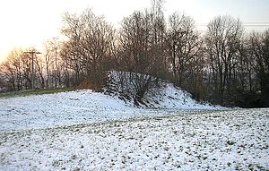
Burgstall Fuchsberg - View of the Burgstall from the east |
||
| Creation time : | High Middle Ages | |
| Castle type : | Höhenburg, spur location | |
| Conservation status: | Burgstall | |
| Place: | Kissing - "Fuchsberg" | |
| Geographical location | 48 ° 18 '8.1 " N , 10 ° 59' 27.3" E | |
| Height: | 525 m above sea level NN | |
|
|
||
The Burgstall Fuchsberg is located on the Lechleite above Altkissing in the Aichach-Friedberg district in Swabia . From the high medieval spur castle at 525 m above sea level. NN have only received traces of the terrain.
history
The Fuchsberg (Eierberg) lies to the north behind the Petersberg with the Peterskirche , which was probably Kissing's first parish church . However, the castle is not located on the southern end of the hill spur, which is favorable for fortification , but about 150 meters north over a cut in the terrain. The fortress was probably the first seat of the local nobility, a Guelph ministerial castle or a Dienstmannenburg of the noble lords of Kissing. In the High Middle Ages, this family built a tower hill castle befitting their rank on the southern outskirts of the village. The Burgstall Kissing has had a baroque pilgrimage chapel since the 17th century.
On the other hand, there are no records of any kind on the history and function of the Fuchsberg in the local historical sources. Except for aerial photographs, the mansion has not yet been archaeologically examined.
description
The Burgstall is located on the wooded slope edge of the Lechrain . In the north, the terrain drops in a steep step about four to five meters. To the east of this terrain level lies the remainder of an embankment, perhaps a tower hill. Here in the east, a shallow depression in the terrain indicates a filled trench. The difference in height to the embankment plateau is about six meters here. However, the castle stables do not show any typical features of a high medieval tower hill castle (motte). In particular, there is no trench around the earth cone, the embankment was apparently placed on the terrace .
The other features of the site were blurred by the agricultural use of the area. The aerial photo archaeologist Otto Braasch was able to document a wall move in the vicinity of the facility .
The Bavarian State Office for Monument Preservation lists the ground monument as a medieval tower hill under the monument number D 7-7631-0066.
literature
- Irmgard Hillar: The three castles of Kissing - today castle stables . In: Kissing: Past and Present . Kissing 1983.
Individual evidence
- ↑ Bavarian State Office for Monument Preservation: Entry ( Memento of the original from March 4, 2016 in the Internet Archive ) Info: The archive link was inserted automatically and has not yet been checked. Please check the original and archive link according to the instructions and then remove this notice.


