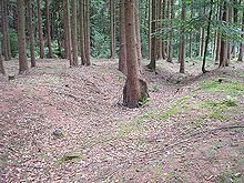
Schwedenschanze (Nisselsbach)
The section fortification of Schwedenschanze is located about 300 meters southeast of the hamlet of Nisselsbach (Ecknach, city of Aichach , district of Aichach-Friedberg , Swabia ) on a hill. The extensive ground monument could go back to one of the numerous early medieval Hungarian fortresses in this area.
Time and purpose
The system on the edge of the "Blumenthaler Holz" is scientifically almost undeveloped. From outward appearances, an early medieval origin of the earthworks can be assumed. The extensive external fortifications and the rather volatile construction of the ramparts could point to an unfinished village fortress or a Hungarian troop assembly point (10th century). While the wall system in the north and west can be seen very well in the terrain, the southern front of the castle was apparently only fortified by palisades or wattle fences. It is possible that the excavation work was also stopped after the Hungarian danger had been removed ( battle on the Lechfeld , 955).
Such castle places often emerged from the expansion of prehistoric fortifications or hilltop settlements. The structure of the core plant is reminiscent of the small ring wall in the Eurasburger forest , the external fortifications to the ring wall in Ottmaringer Holz near Kissing , which was interpreted as a Hungarian period .
The hidden location of the castle away from the town of Ecknach, which was probably founded in the 7th or 8th century, and the typological features are clear indications of the function of the complex as an early medieval protective castle from the time of the Hungarian invasions, which was only used temporarily or even remained incomplete. According to local tradition, the Magyars are said to have set fire to two chapels in the community area. Until a professional archaeological investigation of the site has been carried out, however, the early medieval time of the ground monument must remain speculative.
The popular name "Schwedenschanze" could indicate a reuse of the castle during the turmoil of the Thirty Years' War . It is possible that the population here brought their cattle to safety or hid from the marauding troops. Perhaps subsequent generations also mistakenly associated Burgplatz with this conflict. In Central Europe, numerous prehistoric and early historical or medieval hill castles are called "Schwedenschanzen".
description
The fortification consists of a core structure on a spur that juts out to the west and a section wall several hundred meters long in the northern and eastern foreground. The main plant is separated from the external fortifications by a ten to 15 meter deep cut.
In the southeast of the core plant, two short trench traverses run down the slope to the valley floor. The ramparts piled up behind it are only a maximum of 1.5 meters high. The southern moat continues on the plateau as a front wall. The associated trench is still around two meters deep in places. About two meters below the plateau, a buried ditch or a bench runs around the north and west sides of the main plant. Shortly before the south-western edge of the slope, this terrain level merges into the natural embankment. No clear earthworks can be identified in the south. The slope here seems to be largely untouched.
The front wall protrudes over the inner surface by about one meter. The other edges of the terrain fall into the valley without ramparts. The kinked course of the front wall in the southeast of the main plant is unusual. This results in a small rectangular plateau, the purpose of which is unclear.
The extensive external fortification begins on the eastern plateau in front of the spur of the main plant and runs in an arch to the west to the foot of the hill. In the east, the moat system has been very well preserved. Measured from the bottom of the trench, the wall is up to 2.5 meters high and towers over the terrain by around 1.5 meters. After about 200 meters, the earthworks gradually flatten out and finally run out in the area near a stream. The wall system protected the entire valley area in front of the main plant and provided enough space for a large contingent of troops to stay for a short time.
The Bavarian State Office for Monument Preservation lists the ground monument as a presumably early medieval fortification under monument number D 7-7532-0033.
Web links
Individual evidence
- ↑ Bavarian State Office for Monument Preservation: Entry ( Memento of the original from December 21, 2015 in the Internet Archive ) Info: The archive link was inserted automatically and has not yet been checked. Please check the original and archive link according to the instructions and then remove this notice.
Coordinates: 48 ° 25 ′ 42.3 " N , 11 ° 7 ′ 16.2" E


