Burgstall Bachern
| Burgstall Bachern | ||
|---|---|---|
|
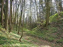
Burgstall Bachern - tower hill from the north |
||
| Alternative name (s): | Old castle | |
| Creation time : | High medieval | |
| Castle type : | Hill castle, moth | |
| Conservation status: | Burgstall, moat, tower hill | |
| Place: | Friedberg - Bachern | |
| Geographical location | 48 ° 18 '11.9 " N , 11 ° 2' 49.2" E | |
| Height: | 516 m above sea level NN | |
|
|
||
The Burgstall Bachern , also known as the Old Castle , is located south of the Friedberg district of Bachern in the Aichach-Friedberg district in Swabia on a hill. From the high medieval hill castle of the type of a tower hill castle (Motte) at 516 m above sea level. NN only the neck ditch and the mighty tower hill have survived.
history
Bachern appears for the first time in 763 as Pahhara in a document. Around 1120 the St. Ulrich and Afra Abbey in Augsburg was wealthy there. Guardian of the monastery property on the other side of the Lech was Count Palatine Otto V. von Wittelsbach .
A local nobility de Pacharn came into the light of history in 1135. In 1140 and 1171, Arnoldus and Gelwart were documented by tenants. A Haidenricus de Bachern gave the monastery further goods in the 12th century. In 1177 a papal bull listed a Meierhof zu Paeche , which already belonged to the Wittelsbach office, district court Aichach in 1270.
The castle was probably already deserted at that time. The former castle in the village was not built until 1595 by the Augsburg monastery Heilig Kreuz , so it was not directly related to the castle stables . Later the west side of the tower hill was partially excavated for material extraction, and the northern outlet of the neck ditch is also disturbed. Through the forest cover of the hill, a typical example is there still a high Motte as a seat of a low noble family of the High Middle Ages. A similar castle stable is only six kilometers west of Kissing on the Lechleite .
The folk legend ascribes the downfall of the fortress to the hard-heartedness of the inhabitants, the castle is said to have sunk into the ground. Only the maid was spared, since she showed pity for the poor. Similar legends are entwined with numerous castle ruins and castle stables. The superstructures certainly served as a welcome quarry for the farmers in the area. The buildings were probably at least partly made of brick, some bricks are still in the area, as well as numerous fragments of roof tiles.
description
The Burgstall is protected in the west by the steep slope. To the south is a plateau - probably a former bailey or tower location - in front. In the north and east, too, plateaus or soil features indicate commercial buildings or farms . The moat of the eastern outer bailey runs about half a meter deep around an angular wall, which towers over the area by another half a meter.
The four to five meter deep neck ditch leads around the east side of the tower hill and continues in the west as a berm or slope ditch. On this side, the terrain drops very steeply into the valley for about 20 meters.
The earth cone of the main castle protrudes another two to three meters above the site, the plateau is difficult to access via the steep flanks. Some larger brick blocks and remnants of brick in the castle area suggest a stone overbuilding.
In the summer of 2007, the ground monument was affected by the construction of a logging path leveled in the ditch. The trench profile in particular was destroyed.
The Bavarian State Office for Monument Preservation lists the ground monument as a medieval castle stable under monument number D-7-7632-0032.
literature
Topographical survey
Ground monuments in the Aichach-Friedberg district . In: Altbayern in Schwaben - Aichach-Friedberg district 1988–1990. Aichach 1990, ISBN 3-9802017-2-4 .
Individual evidence
- ↑ Bavarian State Office for Monument Preservation: Entry ( Memento of the original from October 17, 2014 in the Internet Archive ) Info: The archive link was inserted automatically and has not yet been checked. Please check the original and archive link according to the instructions and then remove this notice.
- ↑ Monuments. (PDF; 159 KB) Bavarian State Office for Monument Preservation, August 22, 2014, p. 22 , accessed on October 14, 2014 .


