Campolattaro
| Campolattaro | ||
|---|---|---|

|
|
|
| Country | Italy | |
| region | Campania | |
| province | Benevento (BN) | |
| Coordinates | 41 ° 17 ' N , 14 ° 44' E | |
| height | 430 m slm | |
| surface | 17.50 km² | |
| Residents | 999 (Dec. 31, 2019) | |
| Population density | 57 inhabitants / km² | |
| Post Code | 82020 | |
| prefix | 0824 | |
| ISTAT number | 062013 | |
| Popular name | Campolattaresi | |
| Patron saint | San Sebastiano (January 20th) | |
| Website | Campolattaro | |
Campolattaro is a municipality in Italy in the Campania region in the Benevento province with 999 inhabitants (as of December 31, 2019). It is part of the mountain commune Comunità Montana Titerno e Alto Tammaro .
geography
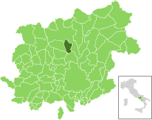
The municipality is located about 15 km north of the provincial capital Benevento in the hill country on the east side of Monte Taburno . The neighboring municipalities are Casalduni , Circello , Fragneto l'Abate , Fragneto Monforte , Morcone and Pontelandolfo . The districts are Ladanza and Botticella.
economy
The community lives mainly from agriculture.
Infrastructure
Street
train
flight
Individual evidence
- ↑ Statistiche demografiche ISTAT. Monthly population statistics of the Istituto Nazionale di Statistica , as of December 31 of 2019.
Web links
Commons : Campolattaro - collection of images, videos and audio files


