Eyjafjallajokull
| Eyjafjallajokull | ||
|---|---|---|
|
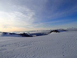
View from the summit crater to the north-west, August 2013 |
||
| location | Southern Iceland | |
| Mountains | Eyjafjöll | |
| Type | icecap | |
| surface | 78 km² | |
| Altitude range | 1652 m - 150 m | |
| Coordinates | 63 ° 37 '30 " N , 19 ° 37' 30" W | |
|
|
||
|
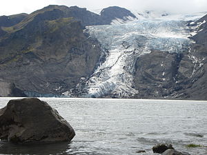
Gígjökull with Lónið glacial lake, 2008 |
||
The Eyjafjallajökull ( [ ˈeɪjaˌfjatlaˌjœːkʏtl̥ ] ), in German Eyjafjöll - glacier , is the sixth largest glacier in Iceland .
It is located on the extreme south coast, west of the Mýrdalsjökull glacier in the municipality of Rangárþing eystra , the highest height is 1651 m . Under the glacier is the Eyjafjöll volcano with its own magma chamber , which has been active since the settlement of Iceland in 920, 1612 (or 1613), 1821 to 1823 and most recently in 2010 .
Surname
The name Eyjafjallajökull ( Icelandic for "Inselberg glacier") comes from the so-called Landeyjar (German land islands ). These are rocky elevations, island mountains , on the sand between the mountains and the sea. They jut out craggy from the completely flat sand plain like islands from a sea and were actually often islands in earlier times before the courses of the glaciers during volcanic eruptions moved the coastline out into the sea with their sediment input.
A number of geographical proper names in this area are compound words with ey (dt. Island ), e.g. B. Petursey , Akurey, Hallgeirsey, Thorvaldsey, Eyjarmýri (German island moor), Eyjarhellir (German island cave) and also Eyjarfjöll (German island mountains ) and Eyjarfjallajökull. Compound nouns in Icelandic generally use the genitive form of the determiner .
The glacier
The Eyjafjallajökull ice cap covers about 78 square kilometers and extends down to an altitude of about 1000 meters.
The highest of the peaks, which protrude from the glacier as small nunataks on the edge of the summit caldera , is the 1651 meter high Guðnasteinn . Other well-known peaks are Goðasteinn in the north of the main crater and Hámundur in the south of the main crater.
Some outlet glaciers descend to the valley floor at 150–200 m above sea level. The most important of these outlet glaciers are Steinholtsjökull and Gígjökull , which extend north in the direction of the Markarfljót stream . The name of the latter Auslassgletscher means crater glacier in German and goes back to the fact that the Auslassgletscher emanates from a large notch in the summit crater. Gígur is the Icelandic word for crater . The steep and rugged outlet glacier extends down about 1200 meters into the valley of Markarfljót. Gígjökull has pushed up high moraines on the valley floor . When the ice masses melted, a glacial lake called Lónið had formed . During the volcanic eruption in April 2010, the glacial lake was completely filled with volcanic ash and sediments and then disappeared.
The volcano under the glacier
| Eyjafjallajokull | |
|---|---|
|
Eyjafjallajokull |
|
| height | 1651 m |
| location | Iceland |
| Mountains | Eyjafjöll |
| Coordinates | 63 ° 38 ′ 0 ″ N , 19 ° 36 ′ 0 ″ W. |
| Type | Stratovolcano |
| Age of the rock | 700,000 years |
| Last eruption | 2010, ongoing |
| First ascent | 1794 by Sveinn Pálsson |
| Normal way | from the Fimmvörðuháls pass |
With Eyjafjallajökull not only the glaciers, but also the entire volcanic massif with several smaller mountains is referred to below.
Shape of the volcano

The volcano belongs to the southern or eastern volcanic zone of Iceland, although the volcanologists are not entirely in agreement on the type of volcano. Þorleifur Einarsson lists it among the stratovolcanoes , Þór Þórðarson speaks of a shield volcano and Ari Trausti Guðmundsson describes the volcano as a "flat, elongated volcanic building".
The volcano's caldera has a diameter of about three to four kilometers. The swarms of crevices belonging to the volcano extend with their craters in a west-east direction over about 30 kilometers. A few more craters formed in March 2010 during the recent eruption at Fimmvörðuháls .
Rocks, lava and ash
The oldest rocks of Eyjafjallajökull are around 700,000 to 800,000 years old. These are so-called transitional basalts (transition type between alkali basalt and tholeiite basalt ), but also more highly differentiated rocks such as dacite . The basalt rock types at this volcano were as hot lava around 1200 ° C and contain a liquid SiO 2 stake by about 50 percent and shares of Al 2 O 3 , MgO , FeO , K 2 O and Na 2 O . The liquid lava cooled to basalt. The lavas in the volcanoes in Hawaii and in Australia in Undara National Park have similar chemical compositions .
Eruption story

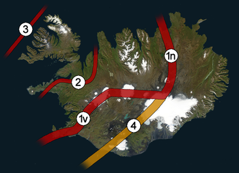
1v: western rift zone
1n: northern rift zone
2:. Snæfellsnes-Skagi rupture zone - inactive
3: Westfjords rift zone - inactive
4: eastern volcanic zone - presumed future rift
valley Eyjafjallajökull is located in the eastern volcanic zone in the immediate vicinity of the south coast

The volcano under Eyjafjallajökull has an eruption history of around 800,000 years. Since the conquest in 870 AD, however, it was only active four times before 2010 and is therefore not one of the most active volcanoes in Iceland.
Prehistoric eruptions
During the Ice Age, twelve different eruption phases can be identified, six of which are interglacial and six more glacial periods.
During the latter period, hyaloclastites and pillow lavas , which also make up parts of the volcanic building, were formed.
Lava layers accumulated during the ice-free periods . These are e.g. B. can be clearly seen in the former sea cliffs on the south side of the mountain range.
After the Ice Age two effusive eruptions occurred about 10,000 years ago , during which the lava flows from Hamragarðar and Kambagil were produced.
Historical eruptions
In contrast, only five known outbreaks have occurred since Iceland was settled. The first erupted in 920, the second erupted in 1612/13, and another in the years 1821–1823. In spring 2010 two eruptions occurred, the first in March at Fimmvörðuháls, the second from mid-April on the summit caldera.
Skerin Ridge and the 920 eruption
In Skerin Ridge is a radial fissure, which is to find the Eyjafjallajökull in the northwest of the summit caldera. The ridge has a length of approx. 4.5 km and a width of approx. 100 m.
Geological examinations of the traces of glacier runs , which have their origin at this ridge, indicate a formation during an eruption under the glacier in the 10th century. Global warming and the associated retreat of the glacier made it possible to analyze the structure of this ridge more precisely, particularly with regard to the rapid cooling of the lavas by the glacier ice.
The results show that the back mainly from trachitischem has built rock (0,043 cubic kilometers), to a lesser extent but also from basalt rocks and intermediate tephra ( trachyandesite consists) (0,012 cubic kilometers).
The eruption apparently began with the formation of a cinder cone at the northwest end of the ice-free fissure and a phreatomagmatic eruption at the ice-covered southeast end of the fissure , which left a tuff wall of the same rock. The eruption was a mixed eruption, explosive and effusive at the same time, with trachitic lavas emanating from a series of vents along the fissure that were quickly cooled by the meltwater of the glacier. The series of outbreaks ended with a strombolian phase .
Petrological investigations showed that shortly before the eruption, magmas of different compositions apparently mixed and a basalt intrusion had triggered the eruption of acidic rock.
Traces of at least one older and undated eruption were also found at the same eruption crevice, which had produced a basalt lava field north of it.
1612 or 1613
Little is known of this outbreak.
A traveler from Moravia named Daniel Vetter described an eruption of Eyjafjallajökull in the winter of 1612 or 1613, the exact date is not known. For a time his report was not considered credible or the description was transferred to an eruption of the Katla , since at that time Mýrdalsjökull and Eyjafjallajökull were under the same name Eyjafjallajökull.
Vetter described the events as follows: For three days there was a terrible roar and crash to be heard from the mountain. The sound reminded him of shots of extremely large cannons. Eventually the mountain flared up, especially in the summit area. Furthermore, a lot of volcanic ejecta fell on a lake at his feet and dried it up in a short time and filled it with burning hot lava and rocks.
Another testimony can be found in the Skarðsannalen. There the eruption is described as follows: "Suddenly the Eyjafjallajökull jumped out into the sea on the east side, and fire came up, you could see that almost everywhere north of land."
The eruption from 1821 to 1823
The penultimate eruption occurred from December 1821 to January 1823. Four million cubic meters of dark gray, fine-grained Dazite ashes were extracted, which are mainly found in southern Iceland. This rather small outbreak did some damage anyway. Above all, the ashes were rich in fluorine , which harmed the cattle. The eruption also caused small to medium-sized glacier runs , especially in Markarfljót , but also in the Holtsá river .
The eruption began on December 19 and 20, 1821, with an explosive phase that lasted a few days and resulted in heavy ash fall, especially in the populated areas in the south and west of the volcano.
The eruption continued until June of the following year, although it was not particularly noticeable in the settlements, apart from a rise in the water level, for example in Markarfljót.
From the end of June 1822 an explosive phase followed, with the explosive outbreaks probably coming in series. The outbreak sent u. a. a cloud at considerable heights. Ash fell in Eyjafjörður in northern Iceland, but also on the Seltjarnarnes peninsula , on which part of the city of Reykjavík lies.
From August to December 1822 the eruption seems to have been less severe. Nevertheless, cattle died of fluorine poisoning in Eyjafjörður and small glacier runs were found in Holtsá on the south side of the volcanic massif. In Markarfljót on the north side, too, a considerable glacier run was found. However, the exact date cannot be deduced from the sources.
In 1823 some men ventured up to Eyjafjallajökull to examine the craters more closely. They found a crevice a little northwest of the Guðnasteinn summit. The men were concerned that the mountain might fall apart because the crevice was very close to the summit and there was only a thin rock wall between it and the abyss.
After the eruptions, it was found that the mountain had changed and a considerable depression had formed in the summit area, where it had previously been more flat.
In the spring of 1823 the neighboring volcano Katla erupted under the Mýrdalsjökull glacier, at the same time more steam escaped from the summit area of Eyjafjallajökull, especially at the main eruption crevice.
Eruptions 2010
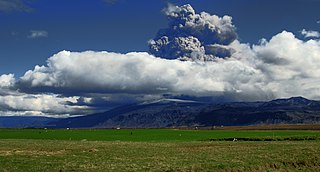
Starting on March 20th, the volcano erupted several times with a large amount of ash. Because no comparative values existed, air traffic over northern and central Europe was largely suspended for several days. As a result of the experience with the eruption, limit values were set in 2010 that were only exceeded in the immediate vicinity of the volcano. In retrospect, the flight bans turned out to be unfounded.
A block of ice on the sand plain of Markarfljót , remnants of a glacier run, photo from May 1st 2010
Correlation of Eyjafjallajökull and Mýrdalsjökull
During the last three eruptions in the Eyjafjallajökull volcanic system in 920, 1612 and 1823, the neighboring volcano Katla under Mýrdalsjökull also erupted at the same time or a little later . So one suspects a temporal operative connection between the two volcanoes. At Fimmvörðuháls (Eng. 'Mountain Saddle of the Five Stone Men'), the transition between Eyjafjallajökull and Mýrdalsjökull, a certain seismic activity has often been detected in recent years.
The geophysicist Páll Einarsson points out the need to monitor Katla , the volcano under the Mýrdalsjökull glacier, very closely, as the eruption under the Eyjafjallajökull in March 2010 could trigger another in the Katla.
Mountaineering on Eyjafjallajökull

The first to climb was Sveinn Pálsson on August 17, 1793.
The easiest way to climb is from the Fimmvörðuháls pass over the ridge to the glacier. The summit crater can be reached in about 3 hours from the Útivist refuge (~ 1050m). An ascent is only possible in good weather, as the summit region is at cloud level. When visibility is poor, it is almost impossible to orientate yourself on the glacier field and to recognize the crevasses.
As an alternative, Ari Trausti Guðmundsson describes an ascent tour from north-northwest direction, starting at the slope to Þórsmörk , over Grýtutindur . However, it is questionable whether this route can still be walked after the 2010 eruption.
Eyjafjöll
The entirety of the southern flank of the Eyjafjallajökull volcanic massif from the Seljalandsfoss waterfall in the west to the glacial river Jökulsá á Sólheimasandi in the east is referred to as Eyjafjöll (Eng. 'Inselberge') . The Eyjafjöll consist of soaring, z. Sometimes several hundred meters high rock walls, as well as some foothills, which after the end of the last ice age about 10,000 years ago initially formed a steep coast, and today have countless waterfalls. Due to the postglacial land elevation of around 60 m, the coastline has now shifted five kilometers to the south and a coastal plain has formed. This is particularly evident at the Skógafoss and Seljalandsfoss waterfalls. The name Eyjafjöll stems from the fact that this side of the mountain from the Westman Islands seen from clearly stands out from the silhouette of the main island of Iceland. The area at the foot of the mountains ( undir Eyjafjöllum = eng. 'Under the island mountains') is protected from cold winds by the high mountains in the north, while mild, humid winds from the south bring a lot of precipitation, making the area the mildest and most fertile heard across Iceland and spring often comes weeks before the wider area. Due to the past as a steep coast, the mountains v. a. in the lower area, small caves broken into the soft rock by the sea surf, the most famous of which is the Paradísarhellir (German Paradise Cave ). It is said to have been the background of an exciting love story in the 19th century. The Icelandic writer Jón Trausti wrote the novel Anna von Stóra-Borg about it .
Þórsmörk
On the north side, the Eyjafjallajökull is bounded by the valley of the Markarfljót and Krossá rivers and the lushly forested ridge Þórsmörk .
Historical events
- On May 16, 1952, a machine belonging to the rescue company of the American troops in Iceland crashed on a flight on the north side of Eyjafjallajökull. There were five people to mourn. Only one body was found immediately afterwards. The corpses of the others were not found until 1964/66 during exercises by the local rescue teams on Gígjökull .
Trivia
- The Boeing 757-200 of Icelandair with the flag TF-FII is named after the volcano.
- In the film The Amazing Life of Walter Mitty , the main actor makes his way to the volcano.
- The 2013 comedy film Eyjafjallajökull - The Inexpressible Volcano Film is about the eruption of the volcano.
- The main belt asteroid (20252) Eyjafjallajökull is named after the volcano.
See also
- Geography of Iceland
- List of mountains and elevations in Iceland
- Volcanoes in Iceland
- Iceland glaciers
literature
- Ari T. Guðmundsson, Ragnar Th. Sigurðsson: Eyjafjallajökull. Untamed nature, Bassermann, Munich 2010, ISBN 978-3-8094-2792-6 .
- S. Hjaltadottir, KS Vogfjord, R. Slunga: Seismic signs of magma pathways through the crust at Eyjafjallajokull volcanoe, South Iceland. In: Icelandic Meteorological office report VI 2009-013, 2009 (pdf; 3.3 MB) .
- A. Hooper, R. Pedersen, F. Sigmundsson: Constraints on magma intrusion at Eyjafjallajökull and Katla volcanoes in Iceland, from time series SAR interferometry. In: CJ Bean, AK Braiden, I. Lokmer, F. Martini, GS O'Brien (Eds.): The VOLUME project - Volcanoes: Understanding subsurface mass movement. School of Geological Sciences, University College Dublin, 2009, pp. 13–24.
- Christof Hug-Fleck: Iceland's natural wonders . Portrait of an extraordinary volcanic island. In: Edition world geographic . Self-published by Christof Hug-Fleck, Au in Breisgau, 2010, ISBN 978-3-00-030427-9 .
- G. Larsen: Gosið í Eyjafjallajökli 1821-1823 (The eruption of the Eyjafjallajökull volcano in 1821-1823). In: Science Institute Research Report RH-28-99, Reykjavík 1999 (pdf) .
- Birgir Vilhelm Oskarsson: The Skerin ridge on Eyjafjallajökull, South Iceland: Morphology and magma-ice interaction in an ice-confined silicic fissure eruption. M.Sc. thesis, Faculty of Earth Sciences, University of Iceland, 2009 (pdf; 14.2 MB) .
- R. Pedersen, Freysteinn Sigmundsson and Páll Einarsson: Controlling factors on earthquake swarms associated with magmatic intrusions; Constraints from Iceland. In: Journal of Volcanology and Geothermal Research 162, 2007, pp. 73-80.
- R. Pedersen, F. Sigmundsson: Temporal development of the 1999 intrusive episode in the Eyjafjallajökull volcano, Iceland, derived from InSAR images. In: Bull. Volc. 68, 2006, pp. 377-393.
- R. Pedersen, F. Sigmundsson: InSAR based sill model links spatially offset areas of deformation and seismicity for the 1994 unrest episode at Eyjafjallajökull volcano, Iceland. In: Geophys. Res. Lett. 31, L14610, 2004, doi: 10.1029 / 2004GL020368 .
- Dietmar Schäffer: The volcanic eruptions on Eyjafjallajökull 2010 . A summary. Rainer, Aschheim 2010, ISBN 978-3-931433-05-5 .
- F. Sigmundsson, H. Geirsson, AJ Hooper, S. Hjaltadottir, KS Vogfjord, EC Sturkell, R. Pedersen, V. Pinel, A. Fabien, P. Einarsson, MT Gudmundsson, B. Ofeigsson, K. Feigl: Magma ascent at coupled volcanoes: Episodic magma injection at Katla and Eyjafjallajökull ice-covered volcanoes in Iceland and the onset of a new unrest episode in 2009. In: Eos Trans. AGU, 90/52, Fall Meet. Suppl., Abstract V32B-03.
- Sturkell et al .: Katla and Eyjafjallajökull Volcanoes. In: Developments in Quaternary Science Vol. 13, 2010, pp. 5-21, doi: 10.1016 / S1571-0866 (09) 01302-5 .
Web links
- [2] , livewebcam, accessed on May 10, 2010, 9:21 pm
Name and pronunciation
On the geology of Eyjafjallajökull
- Eyjafjallajökull in the Global Volcanism Program of the Smithsonian Institution (English)
- Inst. Of Earth Sciences, Univ. Iceland: Brief description of Eyjafjallajökull (English)
- Map with information on the (presumed) historical eruption sites ( gosstaðir ) and crevices ( sprungur ) of the volcanoes Katla and Eyjafjallajökull with dates of the respective eruption, Rút u. Páll Einarsson, Univ. Iceland (PDF file) (Icelandic)
- Magma movements and earthquakes at Eyjafjallajökull, Isl. Weather Office (English, PDF 3.1 MiB)
- Erik Sturkell, Páll Einarsson u. a .: Volcano geodesy and magma dynamics in Iceland. In: Journal of Volcanology and Geothermal Research. 150, 2006, p. 14, doi: 10.1016 / j.jvolgeores.2005.07.010 .
- Martin P. Kirkbride, Andrew J. Dugmore: Two millennia of glacier advances from southern Iceland dated by tephrochronology. In: Quaternary Research. 70, 2008, p. 398, doi: 10.1016 / j.yqres.2008.07.001 .
- Live webcam on the current 2010 outbreak
- Magnús Tumi Magnússon u. a .: Risk assessment of outbreaks in Katla and Eyjafjallajökull (Icelandic) (PDF file; 927 KB)
(see also under literature )
- The volcanic eruptions on Eyjafjallajökull in 2010
- Monika Seynsche : Playing with fire - when volcanoes meet glaciers , Deutschlandfunk - “Science in focus” from August 21, 2010
- Eyjafjallajökull on vulkane.net
Videos and photos
Individual evidence
- ↑ a b Vegahandbókin. Landmælingar Íslands . 2006, p. 135
- ↑ cf. Ari Trausti Guðmundsson: Land in the making. Vaka-Helgafell, Reykjavík 1996, p. 42
- ↑ cf. also: http://wayback.vefsafn.is/wayback/20100815000000/www.earthice.hi.is/page/ies_EYJO2010_word Accessed: January 2, 2011
- ^ Hans Ulrich Schmid: Dictionary Icelandic-German . Hamburg (Buske) 2001, p. 54.
- ↑ cf. Ari Trausti Guðmundsson: Land in the making. Vaka-Helgafell, Reykjavík 1996, p. 42.
- ↑ Ari Trausti Guðmundsson: Living Earth. Facets of the geology of Iceland. Mál og Menning, Reykjavík 2007, p. 205.
- ^ Þorleifur Einarsson: Geology of Iceland. In: Rocks and landscape. 3/2005, p. 70.
- ↑ In English secondary literature the name Thor Thordarson is written; on this and on the text: cf. Thor Thordarson, Armann Hoskuldsson: Iceland. Classic Geology in Europe 3. Harpenden 2002, p. 98.
- ↑ a b c Ari Trausti Guðmundsson: Lebende Erde , p. 204.
- ↑ cf. http://wayback.vefsafn.is/wayback/20100330000000/www.jardvis.hi.is/page/jardvis_eyjogos Retrieved December 31, 2010.
- ↑ T. Thordarson, A. Hoskuldsson: Iceland. Classic Geology in Iceland 3. Harpenden 2002, p. 98 f.
- ↑ Þurfum að fylgjast með Kötlu . Morgunblaðið, March 21, 2010, accessed April 17, 2010 (Icelandic)
- ↑ cf. http://wayback.vefsafn.is/wayback/20100330000000/www.jardvis.hi.is/page/jardvis_eyjogos Retrieved December 31, 2010
- ^ Birgir Vilhelm Óskarsson: The Skerin Ridge on Eyjafjallajökull, South-Iceland. Morphology and magma-ice interaction in an ice-confined silicon fissure eruption. Reykjavík 2009, pp. 6–7 (abstract)
- ^ Vetter, Daniel: 1592–1669. Iceland: ferðasaga frá 17. öld. Hallfreður Örn Eiríksson and Olga María Franzdóttir þýddu, Helgi Þorláksson and útgáfuna. Reykjavík, Sögufélag, 1983, p. 100, quoted in: Veðurstófan: Fróðleiksgreinar, [1] , accessed on May 10, 2010
- ↑ Eyjafjallajökull . islandia.is (Icelandic text: " Sprakk fram Eyjafjallajökull austur allt í sjó; kom þar upp eldur; hann sást nær alstaðar fyrir norðan land. "); Translation Wikipedia - With 'country' here the area from Vík í Mýrdal to Kirkjubæjarklaustur is meant, cf. also the name of the crater group Landbrótshólar.
- ↑ Description after: Guðrún Larsen: Gósið í Eyjafjallajökli 1821. Stutt samantekt. 1999
- ↑ Þurfum að fylgjast með Kötlu . In: Morgunblaðið March 21, 2010 (accessed March 28, 2010)
- ↑ Ari Trausti Guðmundsson: Íslensk fjöll . Reykjavík 2004, pp. 58-59.


