Undara Volcanic National Park
| Undara Volcanic National Park | ||
|---|---|---|
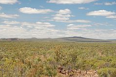
| View of shield volcanoes in Undara National Park | ||
|
|
||
| Location: | Queensland , Australia | |
| Specialty: | Lava tubes | |
| Next city: | Mount Surprise - Cardwell - Townsville | |
| Surface: | 658 km² | |
| Founding: | 1993 | |

The Undara Volcanic National Park is a national park in Queensland ( Australia ) in the McBride Volcanic Province with an area of 658 square kilometers, about 300 kilometers southwest of Cairns . The name Undara comes from the Aborigines and means "long way". In this park there is the longest lava tube of 100 kilometers and the longest lava flow with 160 kilometers. Mount Surprise is roughly in the middle . The national park was founded in 1990 on the former property of the Collins cattle breeding family, who have been based there since 1862 and now run the Undara Experience Lodge.
Lava tubes
In this park, next to a lava tube about 100 kilometers long, which has partially collapsed, there is a pronounced lava tube system that was formed when the main volcano in McBride Province erupted around 190,000 years ago.
The Undara volcano erupted 23 cubic kilometers of lava covering 1,550 square kilometers of area. Its lava flowed in all directions. The bulk of the longest lava flow on earth flowed northwest along Cassidy Creek and Einasleigh River (160 kilometers). Another lava flow, 90 kilometers long, reached the Lynd River.
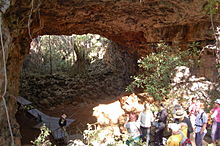
Particularly noteworthy is the large diameter of the lava tubes in the national park, sometimes just over 20 meters and a maximum height of 13.5 meters. Numerous tubes have collapsed, and one of the burglaries is 900 meters long. The ceiling of the Undara tubes is about 5 to 10 meters thick. In some cases, height marks of individual lava flows can be clearly read on the tube walls. The lava flow reached an average thickness of 5 to 20 meters and at the wall section the highest value with 40 meters.
In the Undara National Park, a total of 69 lava tubes are accessible, eight of which are being walked through as part of touristic measures in guided tours (2008) and around 300 have collapsed. The longest accessible tube is about one kilometer long. Numerous bats and other rare animals use the tubes as a habitat.
Formation of the Undara lava tubes
The Undara volcano is one of the youngest volcanoes in this region. The tubes were discovered about 100 years ago and the tube system was recognized by J. C. Best and D. A. White in early 1960. The upper edge of the Undara crater has a diameter of 340 meters and is about 20 meters above ground level. The crater is 48 meters deep and has an internal slope of 40 °. The external slope is 30 ° in the southwest and 5 ° in the northwest. The crater is the highest point in McBride Province at 1020 meters above sea level.
Several prerequisites are essential for the formation of lava tubes: a relatively low inclination of the crater rim ( shield volcano ) and the subsequent terrain profile and large amounts of lava, also a high temperature of 1175 to 1220 ° C, which the lava reached in Undara, a viscosity of 10 to 30 Pa · s and a special chemical composition of the lava. A characteristic of the Undaralava is a proportion of SiO 2 of around 50%, furthermore the proportions of Al 2 O 3 of around 9%, MgO of 8%, FeO of around 8% and Na 2 O around 3%; all other chemical proportions are below 3%. The chemical composition of the Undara lava is similar to that of the lava on the island of Hawaii , in which there are also a number of lava tubes.
When it cools, the lava solidifies to rock, to a basalt . The basalt of this region contains pyroxene , hematite , olivine , magnetite , plagioclase , augite and forsterite .
Undara region
164 extinct volcanoes have been counted in the Undara region and beneath the basalt cover there is reddish colored granite, which shows strong signs of weathering as soon as it comes to the surface. The Undara lava tube system is divided into four sections:
- Crater section with a slope of 1.0 degrees.
- North section with a slope of 0.5 degrees and an extension of 28 kilometers from the crater.
- Yaramulla section with a slope of 0.7 degrees and an extension of 35 kilometers from the crater
- Wall section with a slope of 0.7 degrees and an extension of 35 kilometers from the crater. This section is west of Mount Surprise and the thickness of the basalt there is 40 meters.
The Undara Crater and Yaramulla Section have tubes, some of which have collapsed. No pipes have been discovered in the wall section so far and there are some break-in points in the north section, which indicate the presence of pipes.
In the park there is a shield volcano, the Kalkanikrater, which shows an almost evenly round and uniform terrain profile.
Below the basalt cover there is reddish colored granite (probably 300 million years old), which shows strong signs of weathering as soon as it comes to the surface.
There are the following rivers or brooks in this area, the Einsleigh River, Lynd River , Cassidy Creek, Junction Creek and Elisabeth Creek, as well as a highway that passes by the Undara Crater.
Undara Experience Lodge
In the national park there is the Undara Experience Lodge. Here, in the middle of the Australian outback , you can stay in restored train wagons from the late 19th century or camp on the site. There is a restaurant and even singing and opera performances on certain dates. There are numerous guided tours and free hikes with signage that also include local flora, fauna and history. There is also a gas station on the lodge premises.
literature
- AT Atkinson, TJ Griffin, PJ Stephenson: A Major Lava Tube System from Undara Volcano , North Queensland, 1991, (Reprint from Bulletin Volcanologque Tome XXXIX, 1975)
Web links
- Official website of the Undara National Park (English)
- Undara near Oregonstate (English)
- Pictures from the national park
Individual evidence
- ↑ Australian Government - CAPAD 2010 ( MS Excel ; 170 kB), DSEWPaC , accessed on January 7, 2013 (English)
- ↑ Australian Government - CAPAD 1997 ( MS Excel ; 93 kB), DSEWPaC , accessed on January 7, 2013 (English)


