Forel (Lavaux)
| Forel (Lavaux) | |
|---|---|
| State : |
|
| Canton : |
|
| District : | Lavaux-Oron |
| BFS no. : | 5604 |
| Postal code : | 1072 |
| Coordinates : | 548 690 / 154645 |
| Height : | 716 m above sea level M. |
| Height range : | 640–926 m above sea level M. |
| Area : | 18.51 km² |
| Residents: | 2078 (December 31, 2018) |
| Population density : | 112 inhabitants per km² |
| Website: | www.forel.ch |
|
Forel Church (Lavaux) |
|
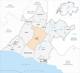
| Location of the municipality | |
Forel (Lavaux) is a municipality in the Lavaux-Oron district in the canton of Vaud in Switzerland .
geography
Forel (Lavaux) is 716 m above sea level. M. , 11 km east of the canton capital Lausanne (linear distance). The scattered settlement community extends on the high plateau adjoining the Jorat to the south-east , north of the Lake Geneva basin, in the Vaudois Central Plateau .
The area of the municipal area of 18.5 km² includes a section of the Jorat Molasse Heights. Almost the entire area is drained by the Grenet and its source streams to the northeast to the Broye . The central part forms the at 690 m above sea level. M. lying plain at Le Plâne, on which the streams Neirigue and Mortigue (from the south) and the Grenet coming from the Jorat (from the north) flow together. East of this plain, the Grenet turns to the northeast and forms the eastern border of Forel (Lavaux). To the north, the municipality extends into the extensive forest area Bois du Grand Jorat (up to 884 m above sea level ), in which the Carrouge rises. In the north-east, the slightly reliefed area of the Petit Jorat (up to 730 m above sea level ) belongs to Forel (Lavaux). In the west, the gently sloping slope of Savigny forms the limit. To the south, the community area extends to the wooded heights of Mont de Gourze, on which 925 m above sea level. M. the highest point of Forel (Lavaux) is reached. About these heights which runs watershed between the basins of the Rhone and the Rhine . In 1997, 7% of the municipal area was in settlements, 28% in forests and woodlands, 64% in agriculture and a little less than 1% was unproductive land.
The scattered settlement community consists of the actual center Cornes de Cerf ( 716 m above sea level ) and numerous hamlets and farm settlements, including Le Pigeon ( 684 m above sea level ), Le Plâne ( 691 m above sea level ), Le Grenet ( 750 m above sea level ), Les Chesaudes ( 724 m above sea level , a single family home) and La Tuilière ( 722 m above sea level ), all located on the plateau southeast of the Jorat, as well as many individual farms. Forel (Lavaux) neighboring municipalities are Puidoux , Bourg-en-Lavaux , Savigny , Servion , Essertes and Oron .
population
With 2078 inhabitants (as of December 31, 2018) Forel (Lavaux) is one of the medium-sized municipalities in the canton of Vaud. 92.2% of the residents are French-speaking, 3.3% German-speaking and 1.4% Portuguese-speaking (as of 2000). The population of Forel (Lavaux) was 1029 in 1850 and 1053 in 1900. Thereafter, a decrease to 833 inhabitants was recorded due to constant emigration until 1960; since then the population has increased again significantly and doubled within 40 years. A strong increase was registered especially during the 1980s.
economy
Forel (Lavaux) was a predominantly agricultural village until the second half of the 20th century . Even today arable farming , dairy farming and cattle breeding as well as forestry have an important place in the income structure of the population. All three economic sectors can currently account for around 33% of the workforce.
An industrial park has been created in the area of Le Pigeon since the 1970s. Construction and information technology companies have settled here; there is also a company that makes kitchen appliances. With the construction of numerous single-family houses in recent decades, the village has also developed into a residential community. Many employed people are therefore commuters who work mainly in Lausanne and the Vevey - Montreux region.
traffic
The community has good transport connections. It is on the main road from Moudon to Vevey , which is crossed here by the Lausanne - Oron-la-Ville road. The closest motorway connections to the A9 (Lausanne-Sion), which opened in 1974 , are Belmont (in the southwest) and Chexbres (in the south), each around 6 km from the town. Forel (Lavaux) is connected to the public transport network by bus route 65 of the Transports publics de la région Lausannoise , which runs from Lausanne to Servion .
history
The first written mention of the place took place in 1274 under the name Fores ; The current name has been passed down since 1300. The place name goes back to the late Latin forestum , which means forest and in the Middle Ages was mostly reserved as a hunting area for aristocratic families. The hamlets and farms outside a closed place were also mentioned in the old French forest .
The once densely forested area of Forel (Lavaux) was cleared and made arable in the 12th century by the monks of the Cistercian Abbey of Haut-Crêt . In the period that followed, the area was controversial between the Counts of Savoy and the Bishop of Lausanne, until the latter bought Forel in 1300.
With the conquest of Vaud by Bern in 1536, the village came under the administration of the Bailiwick of Lausanne . After the collapse of the Ancien Régime , Forel (Lavaux) belonged to the canton of Léman from 1798 to 1803 during the Helvetic Republic , which then became part of the canton of Vaud when the mediation constitution came into force . In 1798 it was assigned to the Lavaux district. Forel belonged to the municipality of Villette until 1824 and was also called Les Monts de Villette . With the division of Villette Forel (Lavaux) became an independent political municipality with the community center in Cornes de Cerf.
Attractions
The church in Cornes de Cerf was built in 1869 and still belongs to the parish of Savigny today. The Tour de Gourze observation tower on the 925 m high Mont de Gourze offers a beautiful panorama of the Lake Geneva basin, the Alps and the Jura.
Web links
- Official website of the municipality of Forel (Lavaux) (French)
- Louis-Daniel Perret: Forel (Lavaux). In: Historical Lexicon of Switzerland .
- Forel (Lavaux) aerial view
Individual evidence
- ↑ Permanent and non-permanent resident population by year, canton, district, municipality, population type and gender (permanent resident population). In: bfs. admin.ch . Federal Statistical Office (FSO), August 31, 2019, accessed on December 22, 2019 .


